Nice & Warm Friday/Saturday, Mostly Dry Weather Continues
WBBJ 7 Forecast Update
WBBJ 7 Forecast Update:
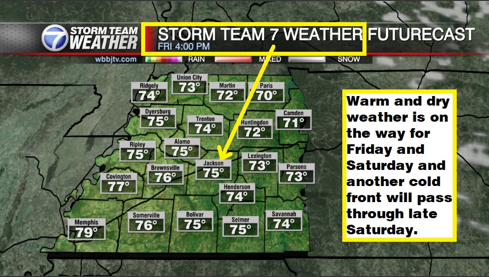
We saw a round of rain showers earlier this morning across West Tennessee but most of us didn’t see much. There are a few isolated showers popping up this evening northeast of Madison county but they will be exiting our viewing area by sunset. Warm and dry weather is on the way for Friday and Saturday and another cold front will pass through late Saturday. Catch the full weekend forecast and find out just how warm things are going to get next week coming up here.

West Tennessee really needs the rain as we have been extremely dry the last 8 weeks. Jackson has only recorded 1/8″ of the rain we usually get for the first half of October and are now over 2.5″ below on the yearly average!
TONIGHT:
The next front will passed through Thursday evening. We saw a few morning showers but not enough to help out anywhere with the current drought situation. There were a few scattered showers along the Tennessee River in the late afternoon and early evening but those didn’t impact many of us. Highs on Thursday still reached the mid 70s before the front passed by. It was a breezy day as well with the winds changing from the southwest to the northwest behind the front. Expect a light breeze out of the west tonight. There likely will not be any lingering showers overnight with Thursday night lows falling down to the low 50s.

FRIDAY:
We are expecting the shower chances to clear out by Friday morning and some clouds will likely stick around for the first half of the day. It will be a little cooler on Friday with highs reaching up to the mid 70s but Thursday’s front doesn’t look like it is going to bring a major cool down our way. The winds will come out of the northwest on Friday and it will be a bit breezy at times as the system moves out to the east of Tennessee. Chances for rain Friday morning before sunrise is 10% but we should be dry most of the day.
THE WEEKEND:
The weather looks like it is going to be quite nice this weekend. We should see sunny to mostly sunny skies and rain showers are not in the forecast at this time. Highs this weekend will make it up to the mid 70s and morning lows will start out around 50°. There doesn’t appear to be any frost in the forecast as we could make it closer to Halloween before we see our first frost in West Tennessee for most of us. The winds will start out of the northwest this weekend before transitioning to the west and then to southwest by the end of the weekend. We could start to warm back up as we get going into next week. It will be a little cooler on Sunday than Saturday but it looks like it is going to be a great weekend.

NEXT WEEK:
Next week looks like it is going to be a warm week for all of West Tennessee. Highs will start in the low to mid 70s before warming up to the mid to upper 70s during the middle of the week. Morning lows will start in the upper 40s on Monday but warm to the upper 50s Tuesday night. We will start the week with mostly sunny skies but clouds will look to increase some as the week goes on. The winds will come out of the east on Monday, southeast on Tuesday and back to the south of Wednesday. Rain chances will look to return towards the back half of the work week and might stick around for the following weekend as well.

FINAL THOUGHT:
We are not expecting much rain in the forecast and the drought is beginning to become a major issue, we need the rain. Another cold front will come crashing through late Saturday but it looks like a dry front with rain chances well below 10%. Above average weather will also stick around for most of the forecast with no frost or freeze concerns in site. The tropics look to be relatively quiet but we are not quite done yet with hurricane season as we are watching a tropical storm Tammy in the southern Atlantic. We got you covered in the WBBJ 7 Storm Team Weather Center as always.

For tips on preparing for the storms, click here. To download the WBBJ 7 Weather app, click here.
Storm Team Chief Meteorologist
Joel Barnes
Facebook: @JoelBarnesWeather
Twitter: @JoelBarnes13
Instagram: @joelbarnes13


