Heavy Rain is Here, Few Storms Possible Tonight
WBBJ 7 Forecast Update
WBBJ 7 Forecast Update:
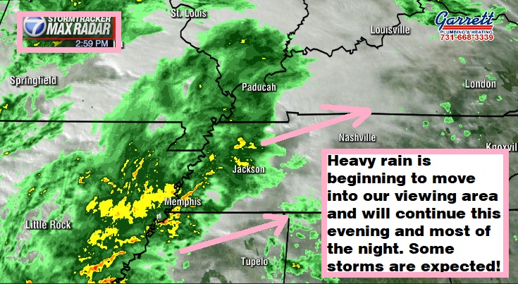
The heavy rain is beginning to move into our viewing area and will continue this evening and most of the night. Some storms are expected this evening but our overall severe threat appears to be low. The greatest threat for a few storms will be south and east of the Hub City. We will be tracking the rain and storms and using our exclusive new radar tonight on WBBJ 7 Eyewitness News. Plus we will have your Thanksgiving forecast as well right here.

For the first time in a few months a significant severe weather threat has returned to the Mid South. Good thing for us here in West Tennessee, is that we are on the northern edge of the severe weather risk. We are expecting some thunder and lightning in areas south of Jackson this evening and a few storms east of Madison county tonight but it does not appear to be overly concerning.

TONIGHT:
Heavy rain showers have returned and will continue overnight for most of West Tennessee. This is some really good news as many locations in our viewing area desperately needing the rain. This is looking like the best case scenario for us as the heavy rain is NOT coming at the cost of severe thunderstorms. The showers will continue overnight and clear out by Tuesday morning. Most of us will pick up over 1/2″ of rain with more of us than not getting over 1″. Some locations could see as much as 2″ before the system clears out!

A storm system with a warm front, a cold front and low pressure system will drift through tonight. Expect cloudy skies all night with temperatures staying the 50s all night long. The winds will vary in direction from the southeast in the evening to the northwest by the morning. It will be a bit breezy at times and some 30-40 MPH wind gusts cannot be ruled out with a few storms if they do develop.

TUESDAY:
The rain showers are forecast to move out by the time the sun comes up on Tuesday. Temperatures will be a bit cool with highs only reaching the mid 50s. Clouds will stick around for most of the day and the winds will be a bit breezy and come out of the northwest making it feel quite chilly most of the day. Tuesday night lows will fall down to around 40° by Wednesday morning. There is a 30% chance for rain early in the morning with chances being the highest near the Tennessee River.
WEDNESDAY:
Wednesday is going to be a cool but dry day across West Tennessee. We should see plenty of sunshine as well with mostly sunny skies hanging around while the sun is up. We could see a few more clouds in the morning before a sunny afternoon moves in. Highs on Wednesday will only make it up to around 50°. Expect a cool day for travel and the winds will be around 10 MPH and come out of the north. Wednesday night lows will dip down near freezing into the low 30s to start off your Thanksgiving.

THANKSGIVING:
We are expecting a mostly sunny, dry and cool Thanksgiving across the Mid South. Highs will reach the mid 50s and the winds will shift from the north to the west during the day. It will be a cold morning and overnight lows will be chilly again falling down into the mid 30s. Bundle up for any of those backyard football games but you can leave the umbrellas at home as rain chances are 0% on Thanksgiving in West Tennessee.

BLACK FRIDAY:
There will be a low pressure system passing just to our south on Black Friday and although a couple showers cannot be ruled out south and east of Madison county, as of now we are not expecting that system to impact us much at all. It will bring more clouds during the day but the rain chances only sit at 20% as of now. We will keep an eye on that system as the week progresses. Highs for Black Friday will stay in the mid or maybe upper 50s and Friday night lows will dip down into the mid to upper 30s making for a cool start to the weekend.
THE WEEKEND:
Forecast models are hinting at another system trying to move in late in the weekend or early next week. The system does not look like it will be here on Saturday but there is a chance it shows up on Sunday bringing some rain showers with it. Big storms or severe weather doesn’t look to be a big issue with this next system but we are several days out and we will be keeping an eye on it as well during the week. Highs this weekend are only forecast to top out in the mid 50s and morning lows will stick around into the 30s. We will see a mix of sun and clouds this weekend with more clouds likely on Sunday than Saturday. The winds are forecast to come out of the north or northwest this weekend and that is why temperatures will likely stay near or below normal for this time of the year.
FINAL THOUGHT:
For the first time in a few months a storm threat has returned to West Tennessee but we will see very little if any severe weather at all due to the location of the low pressure system as it moves through. It will though bring significant rainfall that will help out with the drought problem for the entire region. It will not be enough to fix the issue but it is a good start. Cooler weather will hang around this week and that includes your Thanksgiving, Black Friday and the upcoming weekend.
For tips on preparing for the storms, click here. To download the WBBJ 7 Weather app, click here.
Storm Team Chief Meteorologist
Joel Barnes
Facebook: @JoelBarnesWeather
Twitter: @JoelBarnes13
Instagram: @joelbarnes13


