Cold All Week, Two Shots for Rain Coming to West Tennessee
WBBJ 7 Forecast Update
WBBJ 7 Forecast Update:
Cold weather will be sticking around all week with highs staying in the 40s and morning lows in the 20s until the middle of the weekend. Some patchy fog looks likely tonight and a few sprinkles will be possible on Wednesday, but it will be late in the week when the first round of showers show up for most of us. A more potent system looks to be on the way early next week too. Find out if either of these systems will be bringing any snow or severe weather to the Mid South coming up here.

TONIGHT:
It was a cold day on Tuesday for the entire Mid South. Highs only reached the the low to mid 40s after starting out in the mid 20s. We did see some sunshine early in the day but clouds will be moving back in this evening and we will see a mostly cloudy night on Tuesday. Tuesday night lows will be cool again falling down into the mid 20s. The winds were calm most of the day and will stay that way tonight. Some patchy fog looks likely tonight but we should stay dry as well.

WEDNESDAY:
A low pressure system is going to pass to the south of us on Wednesday and will keep the clouds most of the day before clearing out late into the evening behind a cold front. There could be a few showers along the Tennessee border in counties like McNairy and Hardin but most of us, and all of us north of Jackson will be missing out on the rain from the next system as the front will cut off rain chances for most of us. A few sprinkles or light drizzle could pop up as well. The winds will vary in direction as times as the low pressure system moves away from the Mid South and the late front passes. It will still be a cold day with highs reaching the upper 40s and Wednesday night lows will again fall to the mid 20s. Chances for rain is only 20% for West Tennessee.

THURSDAY:
We are expecting plenty of sunshine on Thursday but it will be another cool day. Highs on Thursday are forecast to again be in the mid 40s with Thursday night lows falling down to the mid 20s. Temperatures will be below all week long in Jackson. The winds will come out of the northeast again behind Wednesday nights weak front. Rain will look to stay away from the region on Thursday.

FRIDAY:
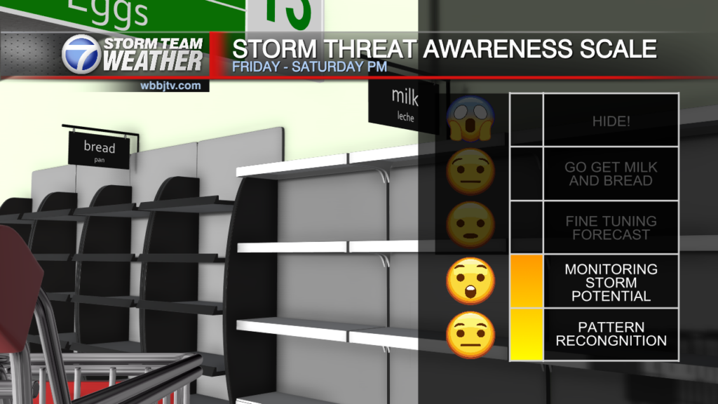
The best chances for rain showers or maybe a wintry mix will be on the way as we wrap up the work week and head into the weekend. Rain chances will increase during the evening and rain looks like Friday night. Chances for anything but rain looks pretty low as of now. Highs on Friday will reach the upper 40s but it is Friday night’s low temperature that we need to keep a very close eye on this week. The forecast low now is 38° which is too warm for a for a wintry mix. If that drops to to 35-36° we could see a brief wintry mix but that looks unlikely. Showers will continue into Saturday morning. As of now, cold rain looks to be the most likely outcome with these system for us.

THE WEEKEND:
Cold rain showers and a very brief wintry mix could be coming down early Saturday in West Tennessee. The showers will move out by Saturday evening. We could see a few lingering showers on the back side of the system on Sunday, but we are not overly confident in chances for precipitation on Sunday. The forecast for showers on Saturday morning though is already at 80% and most likely will increase as the weekend gets closer.
Highs on Saturday will only reach the low 40s and Saturday night lows will fall down near freezing. Sunday highs will reach up to around 50° before we finally warm up back above 50° for everyone by next Monday. The winds will vary in direction this weekend as the low pressure system moves through. Expect a cloudy day Saturday with some potential sunshine breaking through on Sunday.
NEXT WEEK:
A more potent storm system looks to be heading our way late Monday and impacting our Tuesday next week as well. Cold rain showers are on the way for everyone but we cannot rule out a few storms or even a wintry mix as of now. We will be watching that system very closely as it gets closer due to the intensity of the low pressure system according to long term forecast model guidance.

FINAL THOUGHT:
We are going to pick up a slight chance for a wintry mix Friday night into Saturday for all of West Tennessee. A couple degrees higher or cooler than the forecast of 38° could determine what falls down and for who that will mostly likely impact. There looks to be a more significant system coming early next week. We are going to be watching forecast trends very closely this week and weekend and you should as well so you are prepared for what we could see coming down on Friday night and early next week.
For tips on preparing for the storms, click here. To download the WBBJ 7 Weather app, click here.
Storm Team Chief Meteorologist
Joel Barnes
Facebook: @JoelBarnesWeather
Twitter: @JoelBarnes13
Instagram: @joelbarnes13