Rainy & Windy Tonight, 2 More Systems in the Forecast
WBBJ 7 Forecast Update
WBBJ 7 Forecast Update:
Winds could gusts as high as 50 MPH over the next 24 hours and a widespread 1-2″ of rain is coming through Tuesday morning. A few weak storms are expected tonight and a few flurries are possible Tuesday evening. Another system is coming Friday and another next Monday. All three of these storm systems will be packing a punch and the one coming in early next week, is looking like it could be a concerning storm system for us of the winter variety. We will break down all 3 systems coming up here.
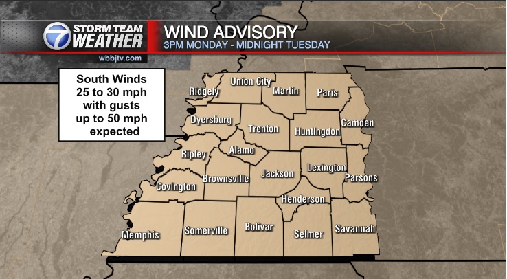
WIND ADVISORY:
A wind advisory remains in effect until midnight Tuesday night for all of West Tennessee. Winds will be sustained between 20-30 MPH with gusts around 40-50 MPH over that time frame. The winds will come out of the south. We are looking at another windy day on Friday too.

TONIGHT:
It is going to be a wet and windy night across West Tennessee. A wind advisory remains in effect and a widespread 1-2″ of rain is expected as well. A few weak storms will mix to, especially south of Jackson but we are not expecting severe weather. It will be cloudy all night long as well. Temperatures will fall down to the low 40s so it will be too warm for anything but rain this go around. Chances for rain are 100% tonight across the region.

TUESDAY:
The heavy rain will continue into the early morning hours on Tuesday before moving out to the east during the mid morning. On the backside of the system some light showers could linger into the afternoon and if the shower linger after sunset, a few snow flurries could try to mix in as well but we are not expecting any accumulation or travel impacts. Conditions will remain windy all day with the winds shifting from the southwest to the west late in the day. Highs will reach the upper 40s and Tuesday night lows will fall down below freezing as the skies should clear out overnight.

WEDNESDAY:
Wednesday will be a decent day with plenty of afternoon sunshine. The winds will be a tad breezy but will be much lighter than on Tuesday and will come out of the west. Highs will reach the upper 40s to near 50° and Wednesday night lows will be a bit chilly and drop into the mid 30s. No rain is in the forecast on Wednesday as the system quickly races east of the Ohio River Valley.

THURSDAY:
Thursday looks to be another mild day as we will remain in-between systems for most of the day. After some early day sunshine, clouds will increase late in the day and into Thursday night. There is a chance for some showers to return late Thursday night but most of us will see the rain stay away until Friday morning. Highs on Thursday will be warm and reach the mid 50s. The winds will be a tad breezy and come out of the southeast into the afternoon. Thursday night lows will be warm due to the southerly winds tapping into the gulf moisture and only fall down to the upper 40s.

FRIDAY:
The next system is coming on in Friday and it looks like it will be quite similar to Monday’s system. We are going to be dealing with gusty winds (likely another wind advisory) and heavy rain showers again. There could be a few storms mixing in as well, so we will need to keep an eye on that. Like the storm system earlier in the week, we cannot rule out a few flurries as the system clears out Friday night but it appears to be another heavy rain event for most of us. Another 1-2″ of rain seems likely before the system moves out. Highs on Friday will reach the mid 50s and Friday night lows could plummet as the system moves out and fall down to the low to mid 20s if the skies clear by Saturday morning.

THE WEEKEND:
The coldest weather so far this season is on the tap for the weekend in West Tennessee. Morning lows will drop down to the low 20s and highs are forecast to only reach the mid 30s. The winds this weekend will come out of the west or northwest and will be quite brisk due to the cold temperatures. Mostly sunny skies are on tap for Saturday but clouds will look to move back in late in the day Sunday. We should see a dry start to the weekend but late Sunday night into Monday, another system will be on the way. The system early next week looks to be quite the attention grabber. It appears as of now, it will be our best shot for some wintry mix, ice or snow. Please keep an eye on the forecast as this might be a bread and milk getting type system next Monday. Highs next Monday might only reach the 20s.

FINAL THOUGHT:
Very heavy rain and winds will move through tonight and again on Friday. These storms will impact ALL of West Tennessee this week. Some areas could see 4″ of rain this week between the two systems. Although some light snow flurries will be possible late Tuesday and again on Friday night, next week’s storm could be a shot for some significant winter precipitation. It is too early to tell if we are looking at a better chance for an ice or snow storm, but we will fine tune the forecast as the weekend progresses and the first two systems clear out.
For tips on preparing for the storms, click here. To download the WBBJ 7 Weather app, click here.
Storm Team Chief Meteorologist
Joel Barnes
Facebook: @JoelBarnesWeather
Twitter: @JoelBarnes13
Instagram: @joelbarnes13


