FLOOD WATCH ISSUED, Heavy Rain Continues this Week!
WBBJ 7 Forecast Update
WBBJ 7 Forecast Update:
So far the rain has been light but will increase in coverage and intensity tonight. Some patchy fog will also be possible northwest of Jackson. A flood watch remains in effect until Thursday evening for West Tennessee. Heavy rain showers will move in tonight and continue overnight into Wednesday morning. More rain will move in late Wednesday and a few non severe storms may pop up Wednesday night into the day on Thursday. A widespread 2-4″ of rain could lead to some localized areas of flooding. More heavy rain and a few storms are also in the forecast for the weekend. Catch the latest forecast details and your hour by hour forecast breakdown coming up here.

TONIGHT:
Rain lingering into Tuesday morning but cleared out into Tuesday afternoon. The break in the rain will be short lived as more rain will move in Tuesday night and stick around into Wednesday morning again. Highs on Tuesday reached the low 50s and Tuesday night lows will only fall down to around 50°. Most of the snow that was left melted away on Tuesday. The winds will continue to be breezy and remain out of the southeast tonight. Skies will remain cloudy tonight as well. Rain chances are 100% tonight across West Tennessee. A flood watch remains in effect until Thursday evening.

WEDNESDAY:
The rainy weather will continue on Wednesday. Like Tuesday, we will get a round in the morning and a break into the afternoon. More rain will return Wednesday night and even a few weak storms may develop as well, but we are not expecting severe weather. Wednesday will be a warm and humid day with highs reaching up to around 60°. Overnight lows will also stay warm due to the humidity and only fall down to the mid 50s. Clouds will stick around most of the day and the winds will come out of the south all day long. Rain chances are 80 on Wednesday.

THURSDAY:
The best shot for a few weak storms will be on Thursday, but the overall threat for severe storms appears to be low. We are expecting heavy rain at times on Thursday and the rain will likely continue overnight into Friday morning. Highs on Thursday will stay well above normal and reach up to around 60° again. Thursday night will be quite warm and we should fall down to around 50° by Friday morning. Clouds will again stick around most of the day and the winds will come out of the southwest. Chances for rain are at 80% as of now.

FRIDAY:
Rain will likely stick around in the morning on Friday before a dry afternoon and evening moves back in. Highs on Friday will again be close to 60° and Friday night lows will drop down to the upper 40s. Chances for rain Friday are 30% early in the day. We should see the clouds break up some into the afternoon and evening. The winds on Friday will come out of the north into the afternoon as Thursday’s system moves out.
THE WEEKEND:
One more system will move through on Saturday before what appears to be a long dry spell starting on Sunday and lasting into next week. Saturday’s rain chance is at 60% and we are not expecting rain on Sunday. We should see mostly cloudy skies on Saturday but mostly sunny skies will return by Sunday afternoon but some clouds will stick around for Sunday morning. Saturday highs will reach the mid to upper 50 but Sunday highs will stay in the mid 40s. Saturday night lows will fall down to around 40° and Sunday morning we could fall back down to the mid 30s but should stay above freezing. The winds will move from the southeast to the northwest on Saturday and then the northwest to the northeast on Sunday.

FINAL THOUGHT:
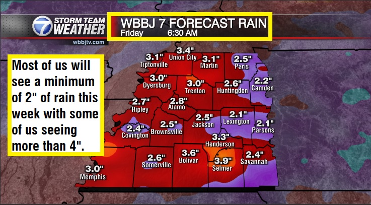
All the snow will melt early this week but will be replaced by several rounds of rain showers. Everyone should see a minimum of 2″ of rain this week with some folks picking up over 4″ of rain. A few storms will be possible but we are not expecting severe weather in West Tennessee this week. Some flooding issues may arise so we will be keeping a close eye on the rivers, creeks and streams later during the week. We might be staying above freezing for the next few weeks too!
For tips on preparing for the storms, click here. To download the WBBJ 7 Weather app, click here.
Storm Team Chief Meteorologist
Joel Barnes
Facebook: @JoelBarnesWeather
Twitter: @JoelBarnes13
Instagram: @joelbarnes13


