Near Record Warmth Again Today, Rainy And Cooler Tomorrow
Saturday Morning Update
WBBJ 7 Forecast Update:

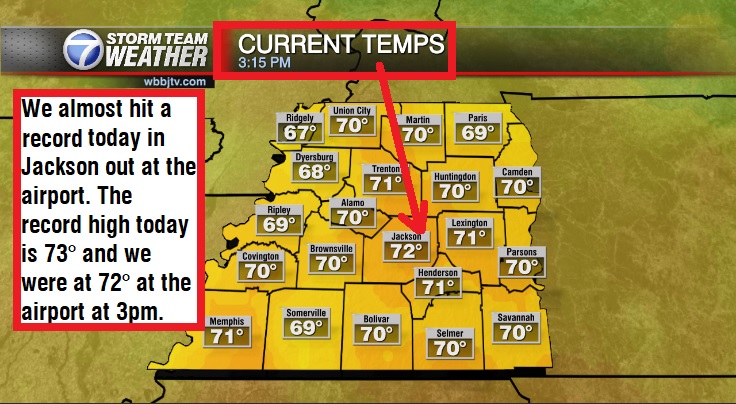
The record high today in Jackson is 73° and we were at 72° at the airport on Friday. We are looking at another warm day Today but we should see a few more clouds. Rain chances will move back in tonight and will linger for most of the day on Sunday in West Tennessee. Catch the latest on rain chances were you live this weekend and find out if we are expecting any storms to mix on in; all coming up here.
GROUND HOG’S DAY:
Friday was Groundhog’s Day, although meteorologists do not put a lot of faith in the rodent’s forecast, it is still a fun game to play. Both Phil and Chuck did not see their shadows suggesting an early spring and too be honest, it is tough to disagree with that. The first 2 weeks of February are forecast to be above normal. That doesn’t mean we wont see a couple more rounds of cold though towards the 2nd half of February or into the month of March.

THE WEEKEND:
The next storm system will pass to the south of West Tennessee this weekend. The system will bring an increase in the clouds on Saturday and some rain chances will return on Saturday night. The mostly likely time for rain this weekend will be on Sunday.

Some of the showers may continue into Monday morning on the backside of the passing low pressure system. The most likely areas to pick up heavy rainfall will be along the Mississippi border but showers are forecast to impact most of West Tennessee.

Expect a cloudy day regardless Sunday. Highs on Saturday will be nice and reach the mid 60s again and only fall down to the mid 40s Sunday morning. Sunday highs will only reach the low 50s due to the rain showers and cloud cover. Sunday night lows will fall down to the low 40s. The winds will start out of the southeast on Saturday but shift to the east on Sunday and back to the north on Monday. Chances for rain are 40% Saturday night, 80% on Sunday and 10% on Monday morning.

NEXT WEEK:
After a few showers early Monday morning, dry weather will be returning into the middle of the week. There could be more showers coming late in the week and into the following weekend but most of the week looks mild and dry. In general, highs will be in the mid 50s for the first half of the week with morning lows in the mid 30s. We are expecting mostly sunny skies during the middle of the week and the winds will come out of the north or northwest. We will keep an eye on the late week rain chances as the system gets closer to West Tennessee. As of now, it appears the chances for rain next week will show up Thursday night and last into the day on Friday. Severe weather seems unlikely again with the following storm system.

FINAL THOUGHT:
After a cold spell, and a wet spell earlier in January, the end of the month and the start of February appear to be quite nice. Highs will make it into the 60s this week but a couple cool mornings are likely as well. We still have 7 weeks of winter left. Many of the rivers and creeks are close to flood stage but none of them currently are forecast to reach even the minor flood stage. We will be keeping an eye on them though this week. The next round of rain is coming this weekend.
For tips on preparing for the storms, click here. To download the WBBJ 7 Weather app, click here.
Storm Team Chief Meteorologist
Joel Barnes
Facebook: @JoelBarnesWeather
Twitter: @JoelBarnes13
Instagram: @joelbarnes13