Warm & Humid Wednesday, Storms Back Late Thursday!
WBBJ 7 Forecast Update
WBBJ 7 Forecast Update:
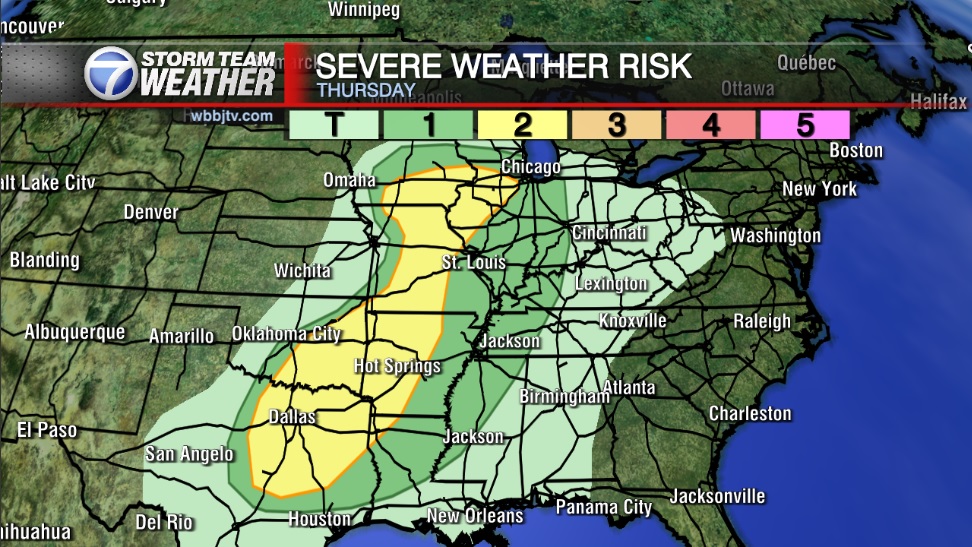
Temperatures have reached over 70° today in West Tennessee and we will be even warmer on Wednesday and Thursday. The humidity will be on the rise as well and storm chances are expected back late Thursday into Friday morning. We are under a marginal (1/5) risk as of now. Temperatures are going to be cooling down and likely below freezing as we kick off Spring next week too. Catch the latest on the storms and potential freeze coming up here.
TONIGHT:
The warm up continued on Tuesday with highs reaching up into the low 70s. The winds were light and came out of the southwest as an area of high pressure is sitting just to the south of us. They will stay out of the south but be light tonight. We again saw mostly sunny skies but a few more clouds will move in tonight. Tuesday night lows will be mild and fall down to the low 50s due to an increase in humidity from the southerly winds. Rain is not in the forecast for Tuesday night.

WEDNESDAY:
West Tennessee is going to be about 5 degrees warmer on Wednesday than Tuesday and warm back up into the mid 70s. The humidity is going to continue to increase as the winds are forecast to stay out of the south all day long. Expect a few more clouds on Wednesday and although it isn’t likely, a brief shower or two could pop up over our northern counties as a warm front is going to pass just to our north. Wednesday night lows will only fall to around 60°. Chances for rain is 20% at best.

THURSDAY:
The next system is going to march closer to West Tennessee and will try to impact our weather Thursday night into Friday morning. The winds will come out of the south and be a bit breezy at times as the front gets a little closer. Expect a mostly cloudy day on Thursday. Thursday will be warm in the upper 70s and Thursday night lows will dip to around 60°. Rain showers and some potential storms are expected as the front passes. The severe weather as of now looks low but storms are going to be likely. Rain chances are 60% Thursday night.

FRIDAY:
It appears early Friday morning will be the most likely time to be impacted with rain and storms, but we are still several days out and the forecast will probably change some over the next few days. Highs on Friday will be early in the day and be somewhere between 65-70°. The winds will change from the south to the west and then to the northwest by Friday night. Friday will also be a cloudy day. Rain chances currently sit at 80% for Friday. The showers will look to stay just to our south on Saturday but Saturday rain chances are going to be very close as the forecast this weekend is looking quite tricky.

THE WEEKEND:
As the front passes on Friday, it will stall out just to the south of West Tennessee. This will keep the clouds around all day on Saturday. A weak low pressure system is also forecast to develop south of us and that could bring a few showers on Saturday to areas south of Jackson. Chances for rain though is only 20% on Saturday. That system will move out of Sunday but we are not expecting the skies to clear out until late in the day on Sunday. Highs this weekend will reach the low to mid 60s. Saturday night will be around 50° but Sunday night lows will dip down into the 30s if the skies clear out. Next week we are likely looking at a freeze Monday night into Tuesday morning. Please do not plant this weekend as we are not done with the freezing weather yet.
FINAL THOUGHT:
Long term forecast models are suggesting a warm end to winter. Spring is about 1 week away and starts on March 19th this year. Since warmer weather returned, , we are still dealing with more of a severe weather threat than a cold and snowy one for the last week of Winter. The next chance for storms is coming in late Thursday this week, and more chances exist in the forecast next week. Cooler weather will be moving in next week as well for the first full week of Spring and a freeze is coming early next week.
For tips on preparing for the storms, click here. To download the WBBJ 7 Weather app, click here.
Storm Team Chief Meteorologist
Joel Barnes
Facebook: @JoelBarnesWeather
Twitter: @JoelBarnes13
Instagram: @joelbarnes13


