Heavy Rain Expected Tonight on Most of the Day on Wednesday!
WBBJ 7 Forecast Update
WBBJ 7 Forecast Update:
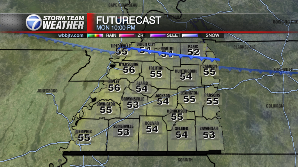
Rain showers will be moving back in this evening and become heavy at times tonight into Wednesday morning. Wednesday mornings commute is going to be wet for the vast majority of us. The showers will continue most of the day on Wednesday but should weaken and diminish in coverage late in the day and into Thursday morning. Expect to pick up between 1-2″ of rain from this system. A few rumbles of thunder will be possible but severe weather or big storms will NOT be coming with this system. Catch the latest on your Halloween and upcoming weekend forecast as well as an update on Hurricane Melissa coming up here.

THIS WEEK:
We didn’t see much of the sun on Tuesday as the next system was moving in and will impact our weather tonight. Clouds returned early in the day and will stick around for the following 36 hours. The rain will move in sometime around sunset and will stick around at least until Wednesday night for most of us. Rain will be getting heavy overnight and especially heavy Wednesday morning impacting the morning commute. Another 1-2″ of rain is coming for most of us with some seeing a little more and some seeing a little less. Highs on Tuesday reached the mid 60s and Tuesday night lows will fall down to around 50° under the clouds and rain. The winds will come out of the southeast as the system begins to move on in and will be a bit breezy at times as well.

Rain will fall most of the day on Wednesday and expect cloudy skies all day as well. Highs will only reach the mid 50s under the clouds and Wednesday night lows will fall down to 40s. If the skies clear out some expect low 40s, if the clouds hang around, expect mid to upper 40s. The winds will come out of the northwest on the backside of the low pressure system as it moves out. The showers should begin to move out overnight into Thursday morning. Storms are not expected but a rumble of thunder or two will be possible.

Thursday morning some showers are expected to continue but most of us will dry by the mid to late morning. The clouds will stick around during the first half of the day before trying to break up and clear out some by the evening hours. Highs will reach the upper 50s as it will be a cool day. As the skies clear out, Thursday night lows will drop into the mid to upper 30s, a frost could be possible but a freeze seems unlikely at this time. The winds on Thursday will continue to come out of the northwest.

Halloween is looking a bit chilly but dry as well. We should see a mostly sunny day and a mostly clear night for Trick-Or-Treating! Highs on Friday reach the low 60s but expect temperatures to hang out between 45-55° during the evening hours. Friday night some clouds may try to move back in and that may keep us out of the 30s. The winds on Halloween will be light for the most part and come out of the west. The next system may show up this weekend but there is not a lot of confidence in the timing or severity of that one just yet.
THE WEEKEND:
There could be another system trying to clip up this weekend with the best chances for rain as of now coming in late Saturday into Sunday morning. We will be keeping a close eye on that one one the midweek system clears out. It does not appear to be as long lasting or as wet as the two systems before it but plenty could change in the forecast as we get closer to the weekend. Highs this weekend will be in the low to mid 60s for both days. Both nights should drop somewhere in the upper 30s or low 40s depending on the amount of clouds we see. The winds this weekend are forecast to come out of the southwest until the system passes, then back to the northwest as it moves out.
Storm Team Chief Meteorologist
Joel Barnes
Facebook: @JoelBarnesWeather
Twitter: @JoelBarnes13
Instagram: @joelbarnes13