Warm & Humid All Week, Storms Coming on Saturday!
WBBJ 7 Forecast Update
WBBJ 7 Forecast Update:
Highs have reached the mid 70s this afternoon in Jackson and temperatures will continue to climb on Wednesday. Highs will be near 80° the next 3 days and it will be quite humid as well. A few pop up showers cannot be ruled out Wednesday and some showers and storms will be possible Thursday near the Bootheel of Missouri. Friday is looking mostly dry for us, but Saturday will be a different story. Storms are looking likely on Saturday and the potential for severe weather will exist as well. We will be watching the set-up closely as the week progresses. Catch the latest coming up here.

THIS WEEK:
Highs on Tuesday will reached the mid 70s and we saw a mostly sunny start to the day. The winds will be a bit breezy at times and will come out of the south. The southerly winds tapped into the gulf moisture and the dew point climbed all the way up into the 60s at times making for a warm and humid day. Showers and storms are not expected Tuesday night, but could be showing up later in the week. The record on Tuesday is 80°, so we fell a bit short. Tuesday night lows will only fall down to around 60°.

We cannot rule out a few showers or weak storms on Wednesday but most, if not all of the activity will stay west of the Mississippi River and north or the Kentucky border. The reason the rain is expected to stay to the north of us is because that is where the front is going to stall out in the middle of the week. Under the front, a heat and humid dome is going to see up and highs will make it up to around 80° by the afternoon. The record on Wednesday is 81° so we are going to be close. The winds will be a bit breezy out of the south and we will see a partly cloudy day as well. Wednesday night lows will fall to the low 60s to kick off our Thursday.

Both Thursday and Friday highs will be in the low 80s near record highs. The record on Thursday is 77° and will likely fall. The record on Friday is 80° and probably will fall as well. We will see a mix of sun and clouds both days. Also, both days, a few showers or weak storms cannot be ruled out just due to the heat and humidity alone. Strong storms or severe weather in our area though is not expected until possibly Saturday. The winds will stay out of the south both days and morning lows will hang around the low to mid 60s.

THIS WEEKEND:
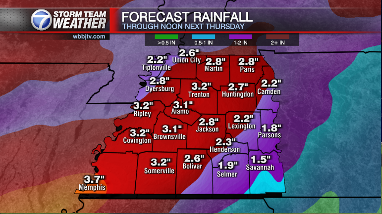
Showers and storms are expected to return this weekend to West Tennessee. The timing and severity of the event are still being determined but as of now, storm chances are 70% on Saturday and 40% on Sunday. Highs will reach the mid to upper 70s on Saturday and low to mid 70s on Sunday. The winds will come out of the southwest on Saturday before turning to the west or northwest for a bit on Sunday and the frontal system will finally push back down to the south of us. Expect a mostly cloudy weekend for the Mid South. The system is coming in from the west so we are not expecting much of a temperature drop on Monday next week.

Storm Team Chief Meteorologist
Joel Barnes
Facebook: @JoelBarnesWeather
Twitter: @JoelBarnes13
Instagram: @joelbarnes13