From Record Lows to Records Highs in the Same Week!
WBBJ 7 Forecast Update
WBBJ 7 Forecast Update:
There were numerous wind damage reports across West Tennessee from Sunday night’s storm event. There were some hail reports and no tornadoes reported in our area. There were tornadoes near St. Louis, in Northern Alabama and Arkansas. There was also a confirmed EF-1 tornado in Alcorn County just south of McNairy county as well as a likely tornado in Southeast Lawrence county as well.

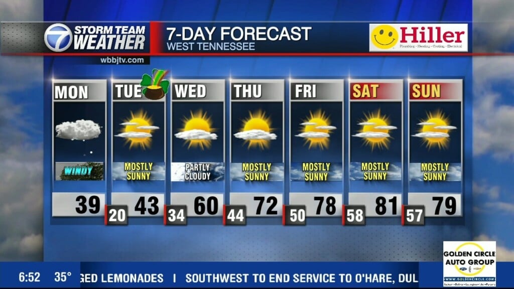
We fell down to 23° this morning in Jackson setting the low temperature record, the previous record was 25° set back in the 1960s. We only reached the low 40s today but 60s are coming back on Wednesday. A warm front north of us is producing some snow showers and as it moves through tonight, some flurries or cold sprinkles could show up, but we are not expecting much. Clouds will move in though tonight but the sun should come back out by Wednesday afternoon. Really nice weather is coming to wrap up the work week and head into the weekend, when more record highs could fall again. We will have it all for you coming up here.

THIS WEEK:
The record was 25° in Jackson set back in 1962 but it was broke today around 6:30am when we fell down to 23°. Tuesday was cold all day with highs again barely reaching above 40°. We did see plenty of sunshine though after a very chilly start. The winds were a tad breezy and came out of the west most of the day. Tuesday night lows will fall down to around 32° as the winds might start to shift to the southwest by the morning. Clouds will increase as the night goes on and a few flurries or light showers could show up, but we are not expecting much.

A warm front is going to squeeze through Wednesday morning and could bring a quick round of light rain showers or even a few more flurries. But as the front lifts through, highs will be back into the 60s by Wednesday afternoon. The winds will come out of the south and be a tad breezy at times. There will be some clouds in the morning but plenty of sunshine in the afternoon. Wednesday night lows will fall down to the low to mid 40s.

The real warm up begins on Thursday and will continue into the day on Friday. Highs on Thursday will reach the mid 70s and upper 70s are expected on Friday. Both days will be packed full of sunshine with a southwest breeze hanging around to wrap up the work week and head into the weekend. Thursday night will drop down to around 50° and Friday night lows will dip into the mid 50s. Dry weather is expected Thursday through Sunday.
THIS WEEKEND:
Highs are forecast to reach the low to mid 80s both days this weekend. We could set or break high temperatures records again this weekend. There will be plenty of sunshine and some clouds could look to return late in the day on Sunday as the next little front will move through late Sunday night or next Monday morning. The winds will kick up some into the day on Sunday but not be too bad. Saturday night will fall down to around 60° and depending on the timing of the front, Sunday night might be a few degrees warmer or a few degrees cooler than 60°. A few light showers will be possible early Monday but it does not look like a severe weather maker or a big storm event for us at this time.

Storm Team Chief Meteorologist
Joel Barnes
Facebook: @JoelBarnesWeather
Twitter: @JoelBarnes13
Instagram: @joelbarnes13