Saturday’s Rainfall Was Not a Drought Buster
It may have rained hard for some folks Saturday afternoon, and some even saw two or three rounds of rain, but the latest totals do not add up to enough to help or very dry conditions here across West Tennessee and those same dry conditions are back for the next seven days at least.
Yesterday:
Radar estimates roughly one-half to three quarters of an inch of rain across West Tennessee. While this will help, it will not be enough to make a significant impact on our drought here. We didn’t miss the highest amounts by much in our driest region. The Missouri Bootheel saw some estimated 2.5 inches of rain.

Tonight:
It will be fairly chilly here across West Tennessee as temperatures will drop down to the low 40s for most. This shouldn’t be too cold for most plants, but you should bring them inside or cover them if you are unsure. Frost is not expected tonight, but some areas could get into the upper 30s, especially north of Jackson.
The Work Week:
Higher pressure will move into the region which will allow for mostly clear days all week long. Temperatures will remain around average with highs in the mid-60s, lows in the mid 40s through about Wednesday before we start to see temperatures climbing through the rest of the week.
Wednesday we will be back into the 70s and Thursday we will be into the upper 70s. Temperatures will begin to head into the 80s by the end of the week and get even warmer as we head into the weekend.
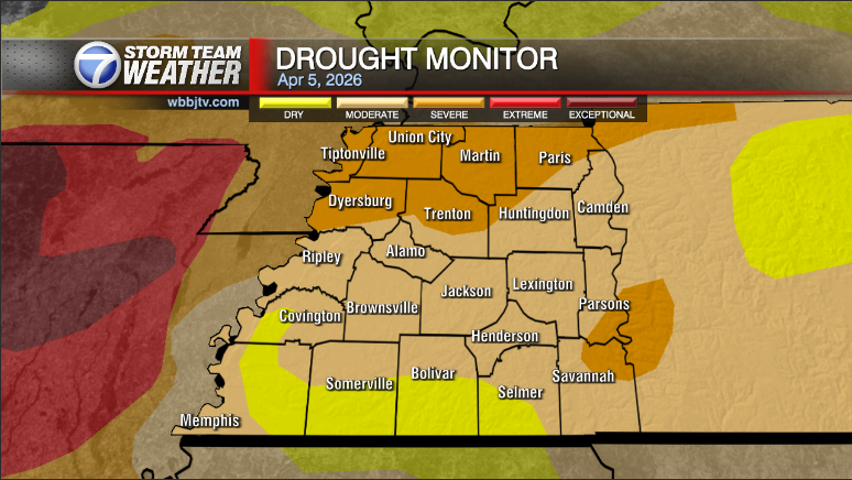
Rain chances return toward the end of the weekend after temperatures get up to the upper 80s on Sunday. Chances for rain next Sunday into next Monday are low, only about 15-30%, but we need all the rain we can get here across the region. Areas north of I-40 are the driest, but there is an area of the highest level of drought just across the river in Arkansas.

We will how Saturday’s rain impacted the drought with the new monitor report Thursday morning.