Very Warm Week, Late Week Rain Shot, Major Change Coming Next Week!
WBBJ 7 Forecast Update:
WBBJ 7 Forecast Update:
Southerly winds have warmed us back into the 80s again today and we will be close to the record of 83°. Near record highs continue through Saturday. Some rain showers will look to return Friday and linger into the weekend but it will be next week when the major changes come. Find out how bad things are going to get next week and if the weather will be putting a damper on your Halloween plans coming up right here.

TONIGHT:
We saw plenty of clouds hanging around for the first part of the day before clearing out into the afternoon hours on Tuesday. Highs on Tuesday reached the low 80s and the record in Jackson is 83°, we got very close and hit 82°. It was also a bit breezy as well with southerly winds hanging between 10-15 MPH most of the day. Tuesday night lows will again stay warm and fall down to around 60° again. Rain showers are not in the forecast for Tuesday.
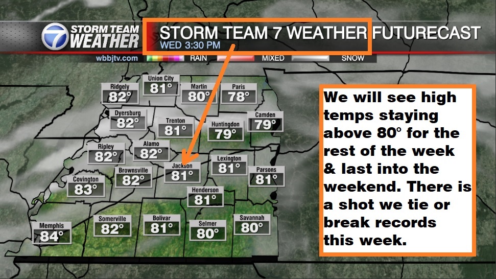
WEDNESDAY:
We are going to see another warm day with a chance of record highs again on Wednesday. The record is 80° and highs will reach above 80° in the afternoon and likely low 80s for most of us. Expect mostly sunny skies although there will be a few clouds at times during the day. It will be a bit breezy again with the winds staying out of the south all day long. Wednesday night lows will be warm and fall down into the low 60s. The weather will feel more summer-like than fall on Wednesday. Again, rain is NOT in the forecast.

THURSDAY:
We will pick up our first chance for rain this week on Thursday but most of us will not see much until Friday. Chances will be best near the Mississippi River as a stalled out boundary near Arkansas is forecast to move to the east as the day progresses. Rain chances only sit at 10-20%. Highs on Thursday will make it up to around 83° with the record being 87°, so we will probably miss it on Thursday. Thursday will be a partly cloudy day with the winds staying out of the south. Thursday night lows will fall down to the mid 60s due to the higher dew point Thursday night.
FRIDAY:
Friday will bring our best shot for rain during the work week but chances are only around 30-40%. The system that will be stalled out just to our west most of the week will finally pass through on Friday. A few rumbles of thunder cannot be ruled out but we are not expecting big storms if we see much for storms at all. We are forecast to see partly to mostly cloudy skies during the day. Highs on Friday will top out in the mid 80s. Friday looks to be our best shot at hitting the record, which is 85° set back in 1950. Friday night lows will only dip down to the mid 60s making for a warm start to the weekend.

THE WEEKEND:
We will see some isolated shower activity on Saturday, but we are not expecting much and the shower should clear out late Saturday and stay dry on Sunday. It will again be a warm weekend with the highs reaching the mid 80s on Saturday and low 80s on Sunday. We could hit or tie another record on Saturday which is 85°. We probably will see a few more clouds on Saturday than Sunday but in general, expect a mostly sunny to partly cloudy weekend. The winds will come out of the south or southwest all weekend long as well helping to keep the temperatures up. Weekend morning lows will stay in the low 60s.

A much more significant system is on the way early next week that will look to impact your plans for Halloween. Rain is coming on Monday but will look to clear out in time for trick-or-treating. It might be a good idea to do some Halloween stuff with the kids this weekend just in case the weather is NOT as great on Halloween night next Tuesday. We could be looking at much cooler weather behind the front next week and our first frost of the season is looking highly likely next week.

West Tennessee really needs the rain as we have been extremely dry the last 8 weeks. Jackson has only recorded 1/9″ of the rain we usually get for the first half of October and are now over 2.5″ below on the yearly average! Over the last 8 weeks, Jackson has only seen 1.32″ of rain when we average close to 8″ on a normal year during those 8 weeks.

FINAL THOUGHT:
We should be dry most of the week in West Tennessee but will pick up a decent shot from Thursday night through Saturday. A cold front will come crashing through again early next week and looks to bring some rain showers with it and potentially a few weak storms. Above average weather will also stick around for the entire forecast with no frost possible until next week. There looks to be a decent shot for some frost or maybe even the first freeze next week. The tropics look to be relatively quiet but we are not quite done yet with hurricane season as we are watching a potential storm in the southern Gulf of Mexico. We got you covered in the WBBJ 7 Storm Team Weather Center as always.

For tips on preparing for the storms, click here. To download the WBBJ 7 Weather app, click here.
Storm Team Chief Meteorologist
Joel Barnes
Facebook: @JoelBarnesWeather
Twitter: @JoelBarnes13
Instagram: @joelbarnes13


