Chilly Holiday and Weekend, Rain Chance Early Sunday
WBBJ 7 Forecast Update
WBBJ 7 Forecast Update:
It has been a chilly Wednesday so far with highs only making it up to around 50°. Those pesky clouds will clear out tonight making for a chilly start to your Thanksgiving dropping down near freezing. Highs on Thanksgiving and Black Friday will reach the mid to upper 50s. The next chance for rain will be passing through this weekend and even colder weather is on tap for next week. Catch all the details and your full holiday weekend forecast coming up here.
A potent low pressure system brought a widespread 1-1.5″ of rain across West Tennessee Tuesday. Here is a look at some of the rain totals across West Tennessee from Tuesday’s rain evening. Almost everyone saw at least an inch of rain but not too many folks saw more than an inch and half either.

TONIGHT:
Wednesday was a cool but dry day across West Tennessee. We saw a little bit of sunshine but an inversion developed into the afternoon bringing some late day clouds back in that should clear out tonight. Highs on Wednesday only made it up to around 50° and the winds made it feel even cooler. Expect a cool travel evening and the winds will be around 5-510 MPH and come out of the north before becoming calm tonight. Wednesday night lows will dip down near freezing into the low 30s to start off your Thanksgiving.

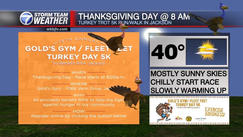
THANKSGIVING:
We are expecting a mostly sunny, dry and cool Thanksgiving across the Mid South. Highs will reach the mid to upper 50s and the winds will shift from the north to the west during the day. It will be a cold morning and overnight lows will be chilly again falling down into the mid 30s. Bundle up for any of those backyard football games but you can leave the umbrellas at home as rain chances are 0% on Thanksgiving in West Tennessee.

BLACK FRIDAY:
There will be a low pressure system passing just to our south on Black Friday and although a couple showers cannot be ruled out south and east of Madison county, as of now we are not expecting that system to impact us much at all. It will bring more clouds during the day but the rain chances only sit at 5% as of now. Highs for Black Friday will stay in the mid or maybe upper 50s and Friday night lows will dip down into the mid 30s making for a cool start to the weekend.
THE WEEKEND:
Forecast models are hinting at another system trying to move in late Saturday night into Sunday morning. The system does not look like it will be here on Saturday but it is looking to show up Sunday morning bringing some light rain showers with it. Big storms or severe weather isn’t expected with this next front. Highs this weekend are only forecast to top out in the low to mid 50s and morning lows will stick around into the mid 30s. We will see a mix of sun and clouds this weekend with more clouds likely on Sunday than Saturday. The winds are forecast to come out of the north or northwest this weekend and that is why temperatures will likely stay near or below normal for this time of the year. Cooler weather looks to be on the way for next week.
NEXT WEEK:
Some of the coldest weather this fall is on the way next week. Highs will start out in the mid to upper 40s for Monday and Tuesday behind Sunday’s front. We should see a mostly sunny start to the week though but with the clear morning skies, overnight lows will drop into the mid to upper 20s for the first half of the week. The winds are forecast to come out of the northwest for the first half of the week as well. There looks to be a chance for some rain showers towards the back half of the work week. As of now, it looks like it is going to come as rain and no chance for winter type precipitation, but it will be something worth monitoring next week.
FINAL THOUGHT:
For the first time in a few months decent rainfall returned to West Tennessee but we will see very little if any over the next 7 days besides maybe Sunday morning. It did help out some with the drought problem for the entire region but we still need a lot more to eliminate the concern. Cooler weather will hang around this week and that includes your Thanksgiving, Black Friday and the upcoming weekend and likely last into next week as well.
For tips on preparing for the storms, click here. To download the WBBJ 7 Weather app, click here.
Storm Team Chief Meteorologist
Joel Barnes
Facebook: @JoelBarnesWeather
Twitter: @JoelBarnes13
Instagram: @joelbarnes13


