COLD Tonight, Mid Week Warm-up. Soggy Christmas Likely!
WBBJ 7 Forecast Update
WBBJ 7 Forecast Update:
Behind the weekend’s cold front, it has been a cold and windy day across West Tennessee. With the clear skies tonight and the very low dew point across West Tennessee, expect morning lows to drop between 20-25° for most of us. If the winds turn calm for a few hours, some might dip down into the upper teens. The cold will not last long and we should be dry through Friday. Some precipitation is expected to return this weekend, but are we expecting storms and is there any chance for snow? We will have the latest on the cold and let you know what type of precipitation we are expecting for the upcoming holiday, coming up right here.
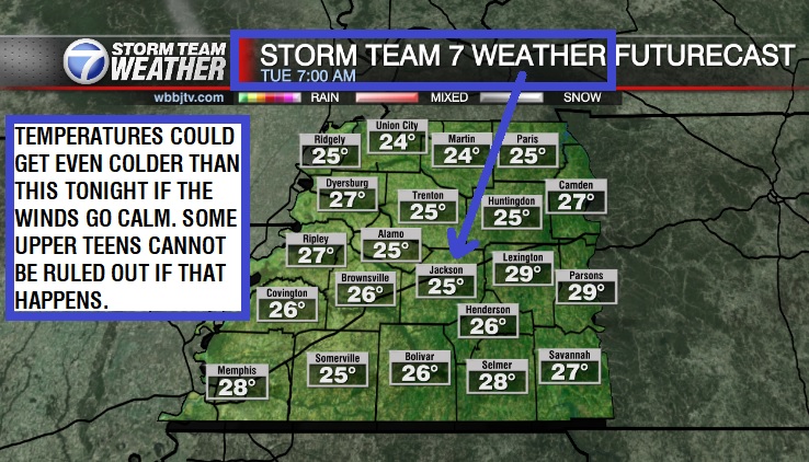
TONIGHT:
Behind the weekend’s cold front temperatures were cool all day Monday and cold weather is expected for our Monday night. We have hit 21° three times this winter with the last time being December 11th but we have not fallen down to 20° or even into the teens yet. Most of us tonight will reach the lower 20s but if the northerly winds go calm for a few hours, some teens will be possible. The winds in general will drop to around 5-10 MPH and stay out of the north tonight. Clear skies are also likely for West Tennessee tonight.

TUESDAY:
The cooler weather will be hanging around all day again on Tuesday. Highs will only reach the mid 40s for most of the region. Sunny skies though will also be hanging around for the last time this week as more clouds will be moving in as the week goes on. The winds will be calm for the most part as high pressure will move directly over us on Tuesday. Tuesday night lows will drop to the mid to upper 20s and be a bit warmer than Monday night as the winds will look to shift to the south by Wednesday morning. Rain is not in the forecast on Tuesday.

WEDNESDAY:
More clouds will move in during the day on Wednesday and we will call it a partly cloudy day and a mostly cloudy night. Highs on Wednesday will reach back up into the low to mid 50s due to the southerly winds returning to the Mid South. Wednesday night lows will be a bit cool dropping down near freezing into the low 30s. Rain showers will stay away again on Wednesday.
THURSDAY:
Thursday will be a mostly cloudy day, but we are still not expecting any rain showers to return to West Tennessee. Highs on Thursday will be a bit warmer than Wednesday and make it up into the mid 50s at least for all of us. The winds will stay light and come out of the south during the day. Thursday night lows will stay above freezing and only drop to the upper 30s as we get going into the day on Friday. By the way, Winter starts officially on Thursday December 21st. This is when the winter solstice will occur and the early will start to tilt back to the north. Thursday will be the day with the least amount of sun this year in the northern hemisphere where we all live.

FRIDAY:
The next system will get a little closer on Friday. That will allow the winds to kick up a bit but they will stay out of the south keeping temperatures above normal again. Highs will approach the 60° mark into the afternoon and overnight lows will only dip into the mid 40s. We are expecting a mostly cloudy day and although a brief shower or two cannot be ruled out late, rain showers will not impact many of us with rain chances sitting only around 10%.
CHRISTMAS EVE WEEKEND:
Rain showers are likely on Christmas Eve on Sunday and a few showers will drift in on Saturday as well. We could see a few storms on Sunday but as of now, we are not expecting this to become a severe weather concern but we will be keeping an eye on the situation as the week progresses. Highs this weekend are forecast to be around 60° with lows staying warm near 50° for both weekend nights. The reason the overnight temperatures will stay well above normal will be due to the increase in humidity and return on the gulf moisture due to a steady breeze out of the southeast. We will not see much of the sun this weekend as cloudy skies are expected for most of the Mid South. Rain chances are 30% on Saturday and 70% on Sunday. Rain also looks likely on Christmas day as well on the back side of the storm system before it moves out.

FINAL THOUGHT:
After a round of severe weather in the middle of December, our next chance for a few storms will return this weekend. As of now, the setup doesn’t look overly concerning for West Tennessee. We also have not fallen below 21° yet this winter but we have a shot of that happening Monday night for some of us. Although we are not expecting snow for Christmas, it seems highly likely that we are looking at a wet and soggy holiday weekend leading into Christmas.
For tips on preparing for the storms, click here. To download the WBBJ 7 Weather app, click here.
Storm Team Chief Meteorologist
Joel Barnes
Facebook: @JoelBarnesWeather
Twitter: @JoelBarnes13
Instagram: @joelbarnes13


