Much Warmer Weather This Week, Rain/Storms in the Forecast!
WBBJ 7 Forecast Update
WBBJ 7 Forecast Update:
The weather has done a complete 180 since last week here in West Tennessee and the warm up will continue for our Tuesday and Wednesday. Temperatures will reach the mid to upper 60s on Tuesday and we will be cracking the 70° mark on Wednesday. A weak front will stall out to our north tonight but it will bring some clouds our way. The next front that will pass is coming Wednesday night and it could bring a few showers our way. There is a better chance for severe weather early next week. We will have that for you as well as a first look into the upcoming weekend coming up here.

THIS WEEK:
After a very cold week last week, warmer weather moved in on Monday and will be sticking around for the most part this week. Highs made it up into the low 60s on Monday but we should top out into the 70s in the middle of the week. There will be a few chances for showers in the forecast but overall we are going to be dry most of the week. There appears to be another concern for severe weather in the forecast, but that will not be here until early next week. So we will keep an eye on it as the week progresses.

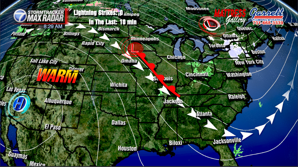
Some clouds will return tonight as a weak front is approaching us from the north. That front is expected to stall out and dissipate before it brings much at all to West Tennessee. The winds will stay out of the southwest tonight and that will keep our overnight lows out of the 30s. Most of us will drop down to the low 40s by Tuesday morning. Those overnight clouds should cleat out quickly during the day on Tuesday. The winds will be calm for the most part on Tuesday and highs will reach up to the mid or upper 60s by the afternoon. Tuesday is looking like a really nice day.

The warmest day in the forecast this week is going to be on Wednesday. Highs should reach the low to maybe mid 70s on Wednesday. The record high on Wednesday is 77° so we should fall short of that. The next front will be coming by Wednesday night into Thursday morning. The front looks like a mostly dry front but there will be some isolated showers between midnight and 6am Thursday morning as the front moves through. The winds on Wednesday will come out of the south before moving back to the northwest on Thursday behind the front. The rain chances should be done by sunrise Thursday.

Temperatures will be a little cooler on Thursday behind the early morning cold front. Thursday morning lows will start out in the mid 40s but highs will struggle to get out of the upper 50s to near 60°, about 10-15° cooler than on Wednesday. Thursday night will be the coldest night in the forecast with morning lows back down to the mid 30s Friday morning. We should stay above freezing but with the clear skies and calm winds, it will be a bit chilly to kick off our Friday. Friday afternoon we will warm up nicely though with highs back into the mid 60s. Expect a sunny day on Friday and the sunshine will continue to kick off the weekend. The winds will be back to the southwest Friday afternoon and Friday night lows will drop down to the mid 40s to kick off the weekend.

THE WEEKEND:
Overall the weekend is going to be pretty decent in West Tennessee. Saturday will be warmer than Sunday as another week and mostly dry front will pass by either late Saturday night or early Sunday morning. There will be more clouds on Sunday than Saturday as well. Highs on Saturday will reach the mid 60s before the front passes and Sunday morning lows will be a bit cool into the upper 30s. Highs on Sunday will reach the upper 50s due to the winds coming back out of the northeast behind the front. Sunday night lows will also be a tad cold dropping down somewhere between 35-40° to start next week.

The next chance for severe weather looks to be in the way for next week. Sometime between Monday night and Wednesday afternoon a powerful system will be moving through. This system looks to be setting up to bring a round of severe weather to the Mid South. We will watch the forecast closely this week and bring you daily updates on the timing of the event as well as who is most likely to be impacted from the storms.

Storm Team Chief Meteorologist
Joel Barnes
Facebook: @JoelBarnesWeather
Twitter: @JoelBarnes13
Instagram: @joelbarnes13