Strong Storms Likely Late Tonight Into Early Monday Morning
PM Sunday Update
Storms were held off by a blocking high pressure system throughout the Weekend allowing some great weather for all of the Easter events. That high is breaking down now and moving away which will allow the storms to move on in late tonight. Although this will be a short term event, there will likely be some severe to strong storms later tonight, especially near the Mississippi River counties including Lake, Dyer, Lauderdale, Tipton, and Shelby County. Storms will slowly loose some steam as they continue east but there will likely still be some hail makers and strong storms all the way to the Tennessee River.
TIMING:
The first storms will start to move into the western counties by around 11 pm tonight. The storms will likely be the strongest at this time.

Storms will lose some of their steam as they continue to the east into the early morning hours of Monday. They will be more near the I-40 area by around 2 am.

Storms will drag along the I-40 areas including Jackson, Trenton, Paris, Brownsville, Memphis, and Somerville areas through around 4 am before moving further eastward.

Storms will continue eastward towards the Tennessee River and counties east by around 4-7 am.
Radar At A Glance:
We will have updates as needed later tonight and here is a look at radar so you can keep up with the storms nearby.
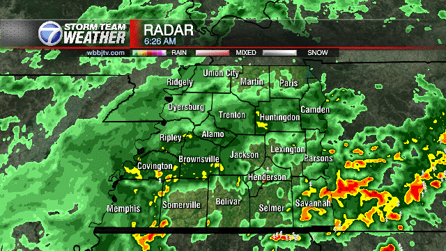
The west Tennessee area looks OK through the evening but later tonight some watches or warnings may be issued. Be sure and refresh this page to get the latest warnings or advisories. We’ll have more updates at 10pm tonight on WBBJ 7 Eyewitness News.
There will likely still be some hail producing storms well into west Tennessee but the overall trend will be for some of the storms to lose their steam as they track through the area. The SPC has expanded the slight risk further to the east as of this evening so that will ultimately up the overall risk for severe storms. Now at a 2/5 risk for severe storms.

The overall risk will still be higher for large hail and damaging gusty winds but a tornado can’t be ruled out.

TONIGHT:
Increasing clouds and breezy with showers and storms approaching late, Chance of rain goes to around 40% by 10pm but increases quickly into the early morning hours. Lows around 63 and south
winds around 10 to 20 mph.

NEXT WEEK:
Warm weather will stick around for most of next week but we will only see highs in the mid 70s on Monday. The showers and storms on Monday will move out by the morning but the clouds could linger around into the late morning. By Monday afternoon, we are expecting the skies to clear. The winds on Monday will shift to the west and then to the northwest late in the day as the front moves through. Monday night lows will fall to the mid 50s and Tuesday highs will make it up to around 80°. We are expecting mostly sunny skies on Tuesday with highs back into the mid 80s on Wednesday. The next chance for rain is coming Wednesday night and some pop up showers and potential storms will try to show up during the back half of the work week as well. As of now, the severe weather threat looks low as these appear to be more of a heat and humidity driven pop up storms instead of being forced by a cold front.
Brian Davis
Storm Team 7 Meteorologist
Twitter – @Brian7wbbj
Facebook – Briandaviswbbj
Email – Badavis@wbbjtv.com


