A Stormy 3 Day Weekend Ahead
Saturday Morning Update
WBBJ 7 Forecast Update:
Just in case you missed it, I will keep the info up on the recent tornado that hit near the airport earlier this week. The latest on our Memorial Weekend Forecast follows below.
The National Weather Service in Memphis surveyed the damage at the Kirkland Factory just to the west of Jackson Regional Airport southwest of Jackson around 3:15pm yesterday afternoon. The tornado was an EF-0 with 75 MPH winds, was 75 yards wind and on the ground for a little more than a mile. No injuries were reported from the brief tornado. Quick note on the severe weather yesterday. The National Weather Service completed a survey in Carroll County. They found sporadic straight line wind damage (maxed around 80 mph) in Clarksburg. We will bring you more storm damage survey’s when we receive them.

Storms will continue west Tennessee mainly from the morning through early afternoon. A couple of storms could become severe, especially over southwest Tennessee. The main threat will be large hail and gusty damaging winds.

Again, Most of or storms for Saturday will move through from morning through early afternoon and some of the storms could produce large hail and damaging winds.

MEMORIAL DAY WEEKEND:
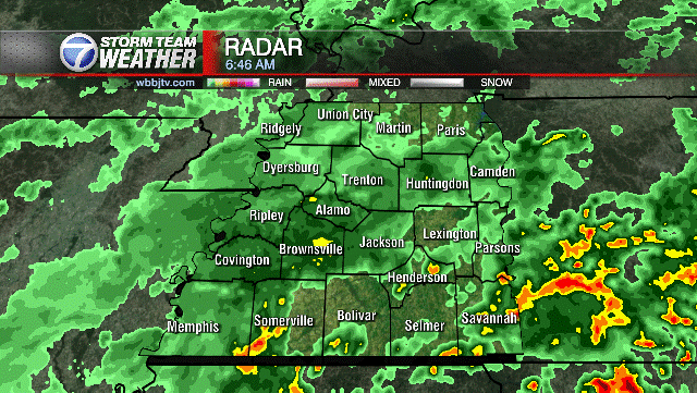
Not great news for the upcoming weekend if you were hoping for 3 nice days. Each day of the holiday weekend will include some rain showers and maybe some weak storms. Severe weather will be be on the lower end threat this weekend but we will have some storms capable of large hail, gusty winds, and frequent lightning. Here is a look at current radar as we track the showers and storms through the area.
For Saturday, The rain chance will be highest through early afternoon then taper off to mostly to partly cloudy skies in the late afternoon and evening.
Most of the rain will move out by late Saturday afternoon and for most, the evening will be dry.

The severe threat is in the lower end bracket but we should still be weather aware this weekend. Sunday early morning through late morning looks to be our overall best shot at some severe weather, so stay up to date with the stormteam.

Lower rain chances will be with us Saturday night but increase again around sunrise on Sunday. A strong round of storms from around 7 am through 11 am looks to be in the making for Sunday but again, most of the rain will move out by the afternoon and we’ll have a nice dry space in there for afternoon and evening.

Sunday will bring a higher severe risk with alot of the area under a 2/5 risk for severe storms and the main threat being large hail, damaging winds, and lightning. Most of the potential severe storms will be in that window between about 7am and 11am Sunday. The afternoon and evening looks mostly dry.

All that rainfall will add up trough Monday to around 3 to 5 inches.

Highs on Saturday and Sunday will be in the mid lower 70s with Sunday maybe being a few degrees warmer. Monday will also be in the mid 70s but probably be a bit more humid as well due to the winds returning out of the southwest. The winds on Saturday are forecast to come out of the east keeping the dew point down a bit. Saturday night lows will fall to the low 60s but Sunday, the winds will return to the south, keeping Sunday night lows up and only falling down to the mid to upper 60s. The humidity will be increasing late in the weekend and that is why we think there is a better chance for storms on Monday than over the weekend. But again, each day we are expecting some rain showers to pop up at least. Expect more clouds than sun all weekend long and there will be several hours of cloudy skies although the sun may try to peek through each day for a couple hours as well.
Brian Davis
Storm Team 7 Meteorologist
Twitter – @Brian7wbbj
Facebook – Briandaviswbbj
Email – Badavis@wbbjtv.com


