Cold All Day Long, Another Potential Wintry Mix Soon
WBBJ 7 Forecast Update: A special weather statement has been issued for the northern counties due to black ice and slick roads until Noon today. More on the weather below. Northwest…
WBBJ 7 Forecast Update: A special weather statement has been issued for the northern counties due to black ice and slick roads until Noon today. More on the weather below. Northwest…

A Winter Weather Advisory will take effect in most of West Tennessee starting Monday evening at 3:00 P.M and lasting through 6 A.M. Tuesday morning. Slick spots, especially on bridges…

WBBJ 7 Forecast Update: We have a round of cold rain showers coming on Saturday between noon-10pm. Temperatures will be well above freezing at the surface but some colder air could…
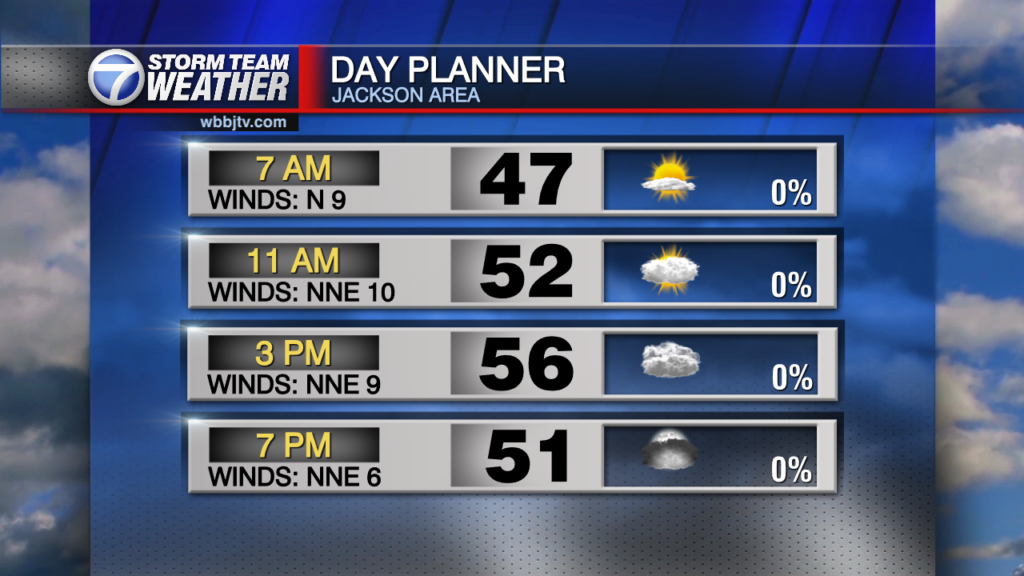
WBBJ 7 Forecast Update: Other than a slight rain chance late tonight, the weekend is looking dry. Today will be our warmer day between the two with highs topping out…

WBBJ 7 Forecast Update: The fog has rolled in thick this morning in many areas in West Tennessee with calm winds and 100% humidity prevalent in many locations. Fog will last into…

WBBJ 7 Forecast Update: Some patchy frost around this morning with highs reaching the mid 60s with sunny skies. Clear and dry during the Trick-Or-Treating hours in West Tennessee. Rain showers are…

WBBJ 7 Forecast Update: Rain will be with us this Monday with most of the rain in the morning hours. The rain will be a cold rain and chilly temperatures…

WBBJ 7 Forecast Update: A sun/cloud mix much of our Saturday but the rain will hold off until sunset for most of us. Once the rain moves in tonight, it…

We'll start to feel the effects of the front that moved through late last night as temperatures will drop into the lower 40s overnight. Winds will calm some from the 30…

Weather Update: Monday, October 20 -- Another cold front will move our way late tonight. This will be a clipper front which typically contains very little precipitation if any but…
WBBJ 7 Forecast Update: Severe weather will be possible as we go into the evening, but ahead of the severe weather we will have a nice day ahead. As it looks…

WBBJ 7 Forecast Update: The nice weather will look to stick around over the weekend but a cold front is going to get very close to us before high pressure moves…

Welcome into the weekend as we are looking rain free ahead. Dewpoints will be lower today making for a fair to comfortable day. We will notice the slight increase in the humidity…

WBBJ 7 Forecast Update: High pressure is now taking control of the weather over west Tennessee and will make for some great weather over the weekend! Starting off in the mid…

WBBJ 7 Forecast Update: High pressure is now taking control of the weather over west Tennessee and will make for some great weather over the weekend! Starting off in the mid…

WBBJ 7 Forecast Update: It has been another hot day for our Thursday, making for 8 straight days with highs 8° or more above average. We will still reach the 90s…

Drought will continue in the area and very little if any relief is in sight. A mostly dry and very hot weekend is coming our way and record setting heat is possible into…

Good Saturday Everyone, Scattered showers and storms brought some needed rain overnight into the morning and while some very local areas saw near 3 inch rainfall totals, most areas received less…

Happy Saturday Everyone! We are in for some pleasant weather over the weekend with continued cooler nights and slightly warmer afternoons around the 90 mark. A few isolated showers will…

WBBJ 7 Forecast Update: A cold front will move our weather for the second half of our weekend bringing a cooler shot of Fall like air for much of next week!…

WBBJ 7 Forecast Update: The heat index is back up to 105° for many of us today and will remain in that range through the weekend. Highs will reach at least…

THIS WEEKEND: Most of our weekend will be dry but a few isolated storms will continue in the hot parts of both days. Rain chances appear to be around 10% for…

WBBJ 7 Forecast Update: Friday was the coolest day of the summer and officially the coolest high daily temperature in a couple months. We hit 82° and that was the lowest…
WBBJ 7 Forecast Update: Friday was the coolest day of the summer and officially the coolest high daily temperature in a couple months. We hit 82° and that was the lowest…

WBBJ 7 Forecast Update: A slight amount cooler Today with the lower 90s, however, a heat advisory remains in effect until 9 pm tonight. For the first time in a…

WBBJ 7 Forecast Update: The temperatures will be lower over the weekend but with the south flow of winds and increasing humidity, it is off setting what would have been…

WBBJ 7 Forecast Update: Some isolated pulse type storms popped up Friday afternoon in West Tennessee. Some developed near the Tennessee River and some have popped up near the Mississippi River.…
We'll have slightly better storm chances tonight due to an old outflow boundary from nearby storms that occurred in Alabama last night. We could see a couple of storms that could…

Dangerous heat will be with us through Friday evening. A heat advisory will remain in effect through 9 pm Friday. The combination of high temperatures, high amounts of moisture in the…
Dangerous heat will be with us through Friday evening. A heat advisory will remain in effect through 9 pm Friday. The combination of high temperatures, high amounts of moisture in…

Our first Weekend in summer is a hot one. In fact, we have a heat advisory in effect both Today and Tomorrow as heat index numbers will be from 100 to…

Its either feast of famine when it comes to rainfall. After intense heavy rain and flooding of Thursday, we are turning the page to intense heat and mostly dry weather for…
Radar estimates had upwards of close to 6 inches of rain over around a 5 hour period this morning for parts of Tipton and Lauderdale Counties in west Tennessee and that…

Skies over west Tennessee are filled with smoke in the mid to upper levels due to distant fires over parts of Canada. Canada has had a very active season with over…

WBBJ 7 Forecast Update: Just in case you missed it, I will keep the info up on the recent tornado that hit near the airport earlier this week. The latest…

Numerous storms moved through on Friday night with sporadic reports of damage, mainly in the northern counties and northwest Tennessee. Several reports of large hail along with around 5 different areas…

WBBJ 7 Forecast Update: Showers and a few storms will develop in the afternoon and early evening hours. A couple of storms will again be strong south of I-40 and there…

Low pressure will keep scattered showers and storms in the weather from now through Tuesday night. After the rain moves out late Tuesday, we'll have a couple of warm to hot dry days. We'll have a good chance at making…
WBBJ 7 Forecast Update: Another mostly dry day ahead for our Saturday. Some spotty showers will try to move back in late Saturday and mainly south of I-40. Spotty showers will…

WBBJ 7 Forecast Update: Yesterday was a busy day in the weather center as numerous strong storms and a few severe storms moved through the west Tennessee area producing large hail…

WBBJ 7 Forecast Update: We are under a marginal (level 1/5) for severe storms, so a gusty wind storm or a brief hail maker cannot be ruled out. Eastern counties…

Happy Saturday Everyone, A stalled out low pressure system and associated cold front will slowly move through the region over the Weekend keeping rain in the area for much of…

Storms were held off by a blocking high pressure system throughout the Weekend allowing some great weather for all of the Easter events. That high is breaking down now and moving…

A chilly start to our Saturday but some pretty weather on the way for the weekend! We'll start off in the upper 30s but head into the lower 60s in…

Multiple supercell and tornadic storms rolled through the west Tennessee area on Wednesday night with Catastrophic damage in the Selmer area. Homes were destroyed and cars flipped upside down along the road for what looked like winds on the EF-3…
WBBJ 7 Forecast Update: The highest risk on the scale for flooding has been issued for some counties in West Tennessee and most of us are now under a level 5/5 (HIGH) risk for severe storms on Wednesday. A supercell…

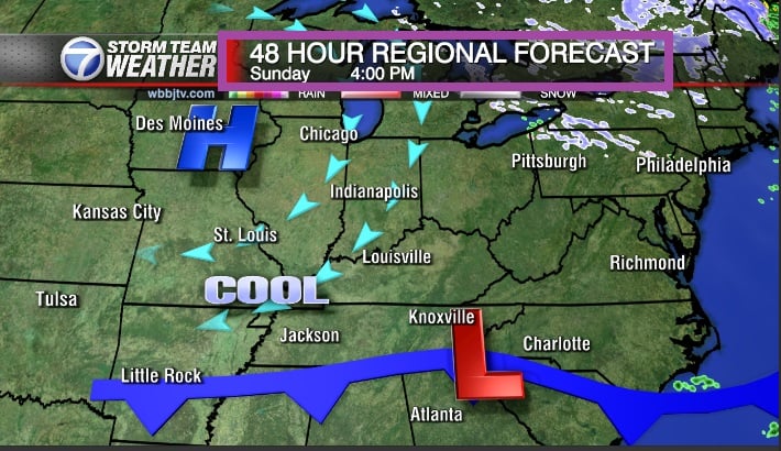
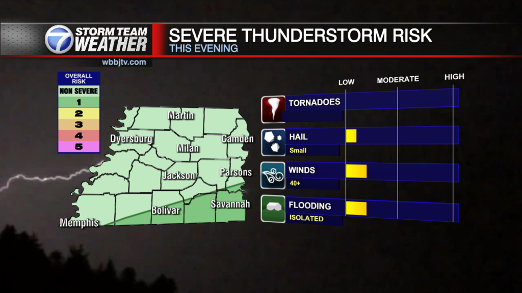
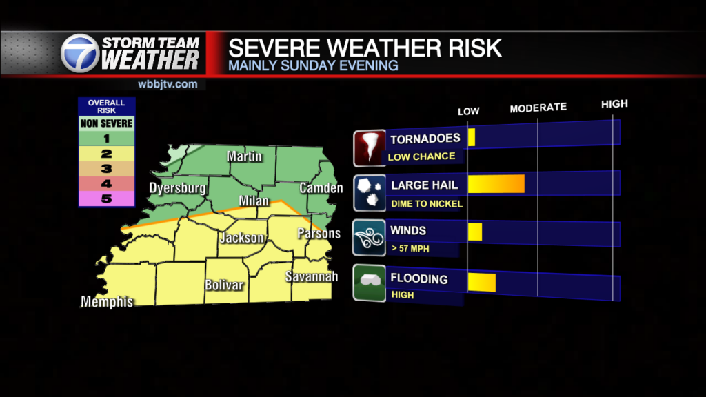
WBBJ 7 Forecast Update: A few showers and scattered storms will be around for our Saturday, but the ingredients by far for severe weather arrive tomorrow evening. Currently, We are…
Good morning everyone on this Friday, March 21st. Starting off a cold morning with lows in the upper 20s under clear skies. Patchy frost has developed and it is cold so…

WBBJ 7 Forecast Update Starting out with abundant sunshine this morning but a return to cloudy skies by afternoon. The front that moved through yesterday has stalled just to…
WBBJ 7 Forecast Update : Starting out with abundant sunshine this morning but a return to cloudy skies by afternoon. The front that moved through yesterday has stalled just to our south and a couple of low pressure system or…