
A Cooler But Dry Weekend, Storms Ahead Tuesday Evening
WBBJ 7 Forecast Update: A cold front moved through early this morning bringing a cooler weekend as the result. The front is a dry front but will bring an increase in…
WBBJ 7 Forecast Update: A cold front moved through early this morning bringing a cooler weekend as the result. The front is a dry front but will bring an increase in…

A southerly flow in our weather will bring our temperatures back into check over the weekend as high temperatures climb into the lower 40s on Saturday afternoon to the lower 50s…

WBBJ 7 Forecast Update: A few snow flurries continue early Today with skies gradually clearing in the afternoon. The sunshine want make a big difference in the cold as windchills…

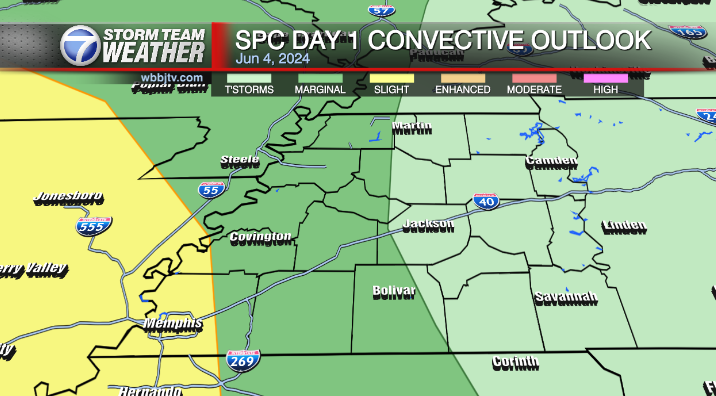
Areas in West Tennessee have been upgraded to an enhanced (3/5) risk for severe storms and the rest of us are under a slight (2/5) risk. A couple tornadoes, large…

WBBJ 7 Forecast Update: We will be about 10-15° cooler on Saturday. The brief cool down will be short lived as highs will make it up to around 70° or higher for 4 days in a row starting on Sunday.…

THE WEEKEND: The warmest weather in over a week will be returning for the upcoming weekend. Highs will reach the upper 40s to low 50s for both Saturday and Sunday. Today will be our nicest day of the weekend with…

Sunday Night Forecast Update: A cold weather advisory is in effect until noon tomorrow as we are expecting overnight low temperatures as low as around 10 degrees and wind chills ranging…

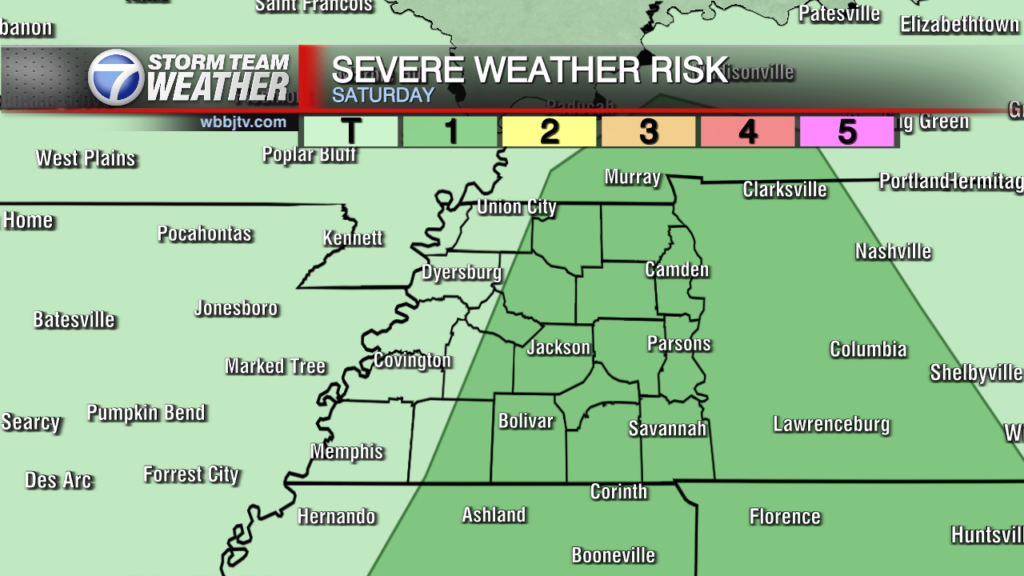
The Storms Prediction Center has upgraded the severe weather risk since last night to a moderate risk. We will have a look at the risk and the…

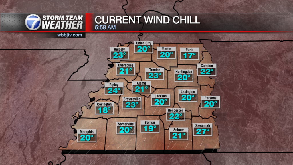
A cold day to start off the first day of Winter with temperatures starting out in the mid to upper 20s and windchills in the upper teens and lower 20s. A…

WBBJ 7 Forecast Update: A weak disturbance will pass through in the late morning and a few snow flurries or sprinkles will be possible in the northern counties…
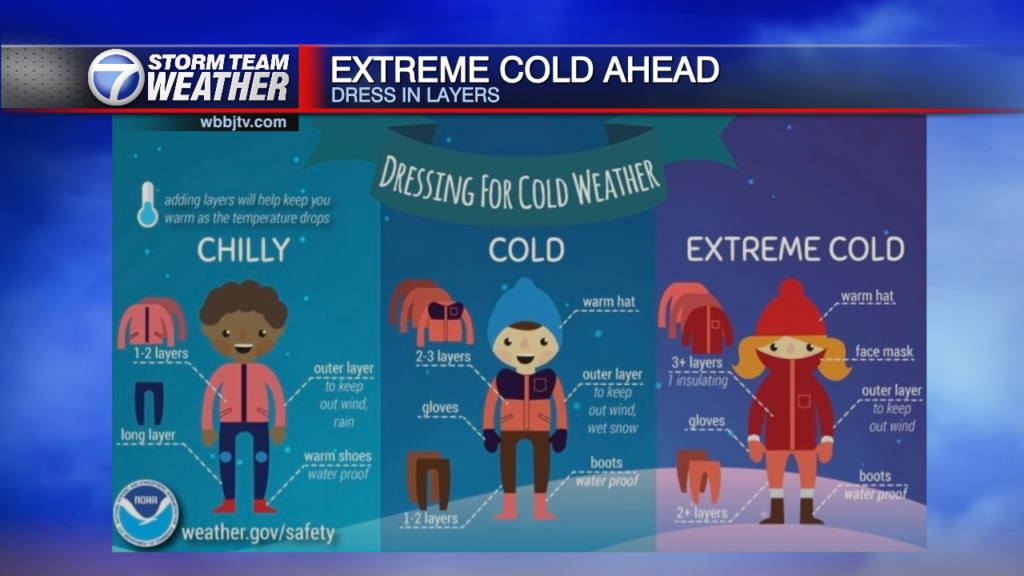
As the fronts moved in last night and early Thursday the coldest weather this fall will be moving on in. The wind chill this morning will be between 10-20° so please layer up. The actual high today will make it…

Breezy but not as cold ahead for our Wednesday morning. Rain will move through just to our south today but a much warmer afternoon is ahead. Our warmup will be short…
A few flurries moved through the area last night and since then, we are partly cloudy with lows dipping into the 20s and windchills in the teens. Todays highs will only…

A weak upper level disturbance will head our way along with another shot of cold air to arrive late tonight. StormTracker 7 radar continues to show some snow showers over…

WBBJ 7 Forecast Update: Frosty cold this morning as temperatures dropped to the upper 20s in Martin, Union City, Paris, and Parsons, while the rest of us were either at…
We had a dry and mild day thanks to high pressure centered near the Ohio Valley. Around the high a southerly flow of winds. Any big rain makers should hold off until at least Monday night as our weather will…

After a nice but short break in the rain Friday, we have more rain ahead today and tomorrow. Rain will be heavy at times as a low pressure area and…
We finally saw some movement with the stalled out frontal boundary as the front moved off to the southeast and out of the area today. After 3 days of on and…

Good Wednesday Everyone! The cold front that brought up to 4 to 5 inches of heavy rain in parts of the viewing area moved south last night and stalled…

Weather Update: Monday, November 5-- Severe weather has been breaking out over the eastern Plains into the 4 Corners area off to our west yesterday. Showers and storms have weakened today…
Weather Update: Monday, November 4-- Severe weather has been breaking out over the eastern Plains into the 4 Corners area off to our west. Showers and storms will continue there…
After getting a fair bit of rain to end October, West Tennessee will see a few nice days before rain returns on Tuesday. Most of the area picked up between 1-2 inches…

Thursday Night Update: The storms moved out just ahead of Halloween evening as expected and we'll now turn towards a drier and cooler night ahead with lows dropping into the lower…

UPDATE: Wednesday Evening We've have enjoyed another pleasant day in the lower 80s for our Wednesday, but stormy weather is on the way... Rain and a few strong storms possible…
We just finished up another sunny and warmer day but not quite as warm as yesterday when we tied a 2016 record of 85° for the high. Today, we made…

After a mostly dry and cooler weekend, warmer weather has returned as a warm front lifts in around an area of high pressure. The surface high will remain just to…

A cold front moved through the area overnight and behind the front are some scattered showers and storms. Showers and storms will continue to push southeast over the area today and…

WBBJ 7 Forecast Update: Cooler weather will stick around for a few days but another warm up appears to be on the way for the upcoming weekend. We will let you…

In just about and hour's time this morning, the pressure dropped 10 mb from 954 to 944 indicating just how fast this system is developing. Winds had jumped from a…

WBBJ 7 Forecast Update: Post tropical cyclone Helene is still slowly crawling the the west today. The storm will stall out and not move much at all on Saturday. The…
Hopefully you enjoyed a quick tease of fall the last couple days. Summer weather is moving back in and will be sticking around into next week. Highs could reach up to…

A cold front has brought a little break in the extreme heat and high pressure will settle in making for a very stable weekend of sunny skies. The heat will…

WBBJ 7 Forecast Update: Rainfall has stacked up over the last 24 hours with with bands for rain and scattered storms and more rain is expected today. We'll likely pick…

WBBJ 7 Forecast Update: Scattered storms and patchy dense fog this morning the afternoon will include some scattered storms. We are not expecting big storms or severe weather, but showers are…

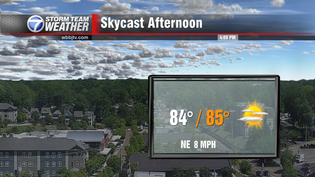
WBBJ 7 Forecast Update: Temperatures are going to continue to climb this weekend as a light breeze out of the southwest is expected to return. Highs will reach the mid…

A cold front brought scattered storms on Friday but now we'll benefit from the cooler air as we head into the weekend. Rain will be located far to our south along…
After a very hot weekend a cold front brought a cooler morning to the area with some areas dropping into the lower 60s early. Behind the cold front we have…

AHEAD IN THE WEATHER: We had our second day in a row of lots of sunshine after a cloudy start to our week. Our high topped out at 94° which…
AHEAD IN THE WEATHER: We saw a return to sunshine today along with slightly warmer temperatures. Our high topped out at 92° which is above the average for this time of…

AHEAD IN THE WEATHER: The tropical disturbance of earlier this week has now developed into Tropical Storm Alberto but for us a strong pattern of high pressure will continue to…

AHEAD IN THE WEATHER: A strong ridge of high pressure continues to build into the area and expand back further west, taking most of the rain with it. The southerly…

AHEAD IN THE WEATHER: A strong ridge of high pressure continues to build into the area and expand back further west, taking most of the rain with it. The southerly…
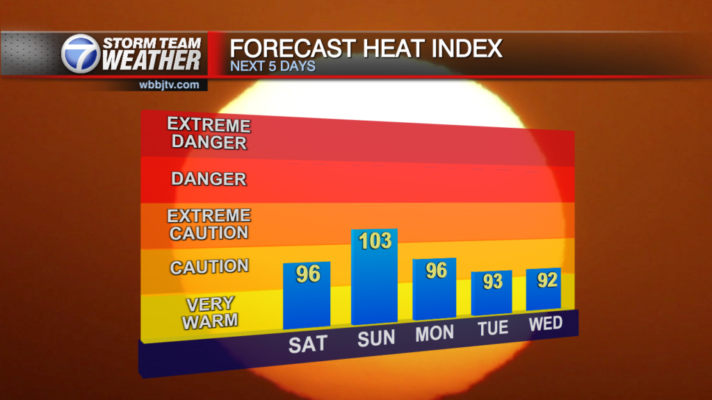
A mostly dry weather pattern will settle in for the weekend as high pressure in the bigger picture will combine with abundant sunshine and lack of breezes to make for a hot Father's Day weekend. Chances will remain very low…

WBBJ 7 Forecast Update: Another storm system is on the way and will look to impact West Tennessee this weekend. Scattered showers will develop into the morning hours of Saturday with…

WBBJ 7 Forecast Update: Showers and Storms will continue to move through the area this morning followed by a break in the rain most of late morning through the early…
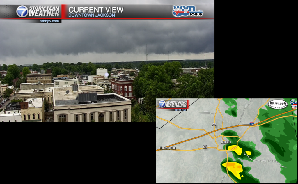
Very heavy showers have popped up through the morning around an area of low pressure moving through the area now. Although lightning has been very limited in the activity, rain has been locally heavy under some of the clouds. We…
Good Monday Everyone, After a peaceful morning in the mid to upper 60s, we are heading into the upper 80's this afternoon. Scattered storms enter the picture mid to late afternoon with a low end threat for storms strong to…
Good Saturday Everyone... The month of May was a wet one as we came in at 9.30 inches of rain for the month which was around 2.33 inches more than last year at this time. The normal according the the…

WBBJ 7 Forecast Update: A slow moving low pressure system will move through West Tennessee this morning through early afternoon Saturday. Dry weather with mostly sunny skies will return on Sunday.…

WBBJ 7 Forecast Update: We are expecting a warm, humid, breezy and mostly dry weekend across West Tennessee. Saturday will be warm and dry. Next shot for storms coming Sunday night.…