Cold Wednesday Morning but Nice Weather Most of the Week!
Tuesday Night Forecast Update
Tuesday Night Forecast for March 2nd:
As the showers and clouds move out tonight, high pressure will be moving in. Plenty of sunshine, warmer temperatures and a light westerly breeze will return for the middle of the week. A weak front will move through late Thursday into Friday but nice weather will quickly return for the weekend. Catch the latest details and your full weather forecast right here.

TONIGHT:
The showers have wrapped up tonight and the clouds will follow, expect mostly clear skies by sunrise. Winds will go calm as the night goes on and morning lows will drop down to the low 30s.
WEDNESDAY:
Sunny skies should return for the middle of the week and temperatures will warm up some as the winds will start to come out of west. Highs will make it into the upper 50s, but it will be cold again in the morning with temperatures down near freezing around sunrise.
THURSDAY:
Mostly sunny skies will stick around for Thursday and temperatures will continue to rise. Highs should reach the low 60s and the winds will stay light. Rain will not be likely anywhere across the forecast area. Temperatures will be in the mid to upper 30s in the morning.
FRIDAY:
Some chances for light rain will return on Friday as the next system will drift through West Tennessee. It appears that rain chances will be minimal and no storms are currently in the forecast. Highs will drop to the low to mid 50s behind the front and winds will come out of the north by the afternoon. Friday night lows will move back down into the mid 30s.
THE WEEKEND:
For the first time in few weeks nice weather looks to be heading our way for the weekend. High will reach the upper 50s and Saturday and low 60s on Sunday. It will be a bit chilly though on Sunday morning dropping into the low to mid 30s. Each day should be packed full of sunshine and the winds will start to come out of the southeast as the weekend goes on. Rain is not expected during the entire weekend, so make some outdoor plans.
NEXT WEEK:
Very warm and nice weather is expected for the beginning of the upcoming work week. Highs will be in the mid to upper 60s with plenty of sunshine for both Monday and Tuesday. Some clouds and a few showers could move in Tuesday night and a chance for showers could return by next Wednesday for most of us.
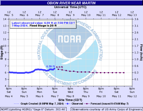
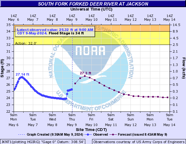
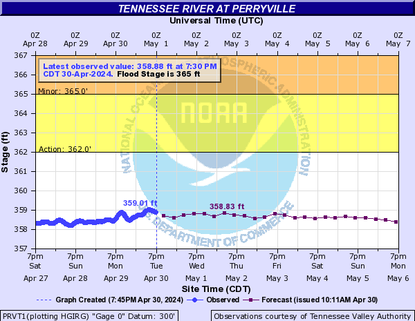
FLOOD WARNINGS:
Many rivers and streams will continue to run high this week. The water levels are expected to be going down though this week due to the fact there is very little rain in the forecast. Here is a look at Obion River near Martin, the Forked Deer near Jackson and the Tennessee River near Savannah water level forecast this week. All three rivers are currently under flood warnings issued from the National Weather Service out of Memphis.
OBION RIVER

FORKED DEER RIVER
TENNESSEE RIVER:

Storm Team Chief Meteorologist
Joel Barnes
Facebook: www.facebook.com/joelbarnesweather
Twitter: www.twitter.com/joelbarnes13
Instagram: @joelbarnes13


