Very Pleasant Over The Weekend
WBBJ 7 Forecast Update: We have one the last hot weekends of 2023 on the way tomorrow and Sunday as a legit cold front looks to be on the way late…
WBBJ 7 Forecast Update: We have one the last hot weekends of 2023 on the way tomorrow and Sunday as a legit cold front looks to be on the way late…
Showers and storms on Thursday evening put close to 2.5 inches of rain down in a short amount of time while most of us continued to stay dry. Although there will…

WBBJ 7 Forecast Update: High pressure will continue to build in and a slight warming trend ahead Today as afternoon high temperatures top out at 86. Our next cold front is heading…
WBBJ 7 Forecast Update: Some great Fall Preview weather just in time for the weekend. A light north breeze will continue which keeps out humidity lower. Rain chances will be very slim…
WBBJ 7 Forecast Update: A cold front brought some unseasonably cool weather to the area along with plenty of sunshine and north winds. Another weak cold front will move through early tomorrow…

WBBJ 7 Forecast Update: A cold front brought some unseasonably cool weather to the area along with plenty of sunshine and north winds. Another weak cold front will move through early tomorrow…
WBBJ 7 Forecast Update: LABOR DAY WEEKEND: As of now we are not expecting much for rain this weekend but a stray shower or two cannot be ruled out. Winds will…
WBBJ 7 Forecast Update: Fall lovers rejoicing today across all of West Tennessee with morning lows falling into the 50s. This morning we dropped to 54 in Jackson and the lowest temperature…

WBBJ 7 Forecast Update: The morning has brought some patchy dense fog but otherwise rain chances will be very limited for the first half of our Saturday. We are expecting one more…

WBBJ 7 Forecast Update: A heat dome continues to build to our west and will start to affect the area into the Weekend. The heat and humidity will be returning though by the…

Weather Update: Thursday Evening, August 17 -- Another beautiful sunset for our evening weather and very pleasant temperatures falling through the 70's into the upper 60's. We say goodbye to…
Weather Update 8/15 Tuesday: A weak pressure trough will move through the area this evening with some patchy clouds and northwest winds that will gust up to 20 mph at times. A…
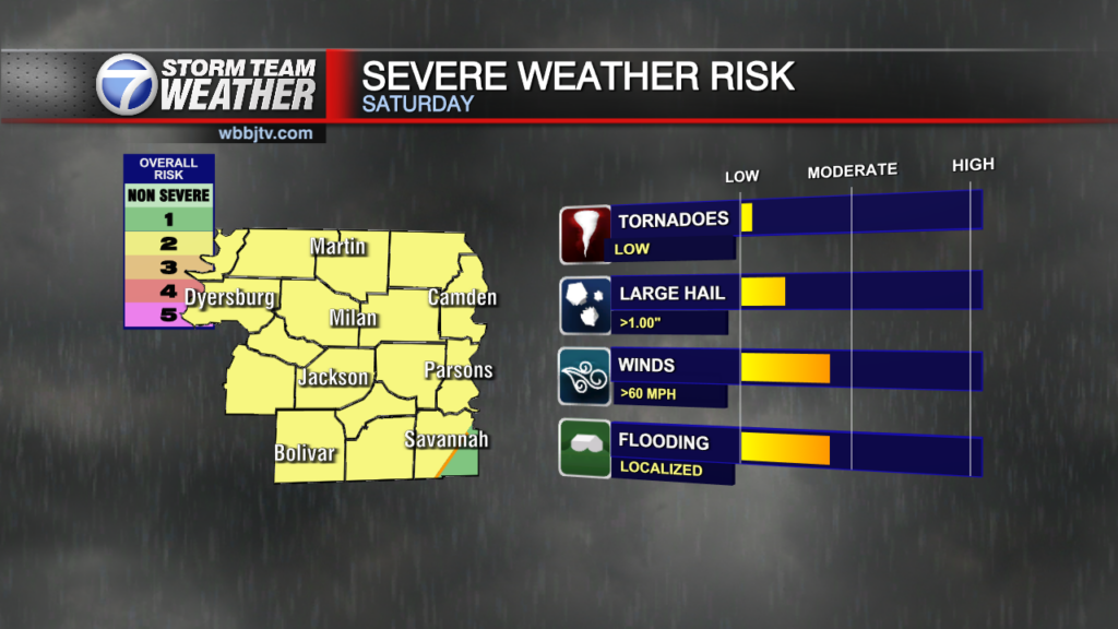
Update Saturday 11 AM More rounds of storms will develop and move through the area today. Storms will again be capable of becoming severe with damaging winds, hail, and numerous amounts…
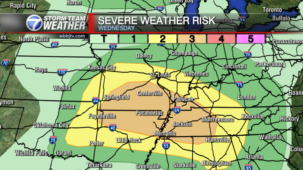
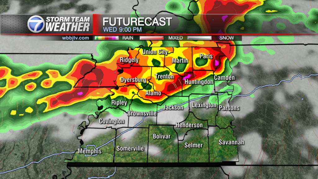
WBBJ 7 Forecast Update: A potent and explosive storm system will move across West Tennessee Wednesday bringing several rounds of showers and storms. Storms will occur in the late morning and early…
Forecast Update 8/8/23 Periods of clouds along with a low end chance for a shower or two later today. Storms will push through just to our southwest for our Tuesday. A warm front will move over the area tomorrow with…

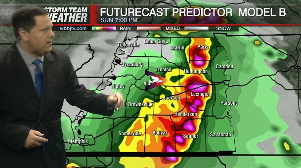
Locations near Union City saw up to 16" of rain over the last 48 hours and areas in northern Gibson county saw over 12". More showers and storms are in the forecast…

WBBJ 7 Forecast Update: Locations near Union City saw up to 16" of rain over the last 48 hours and areas in northern Gibson county saw over 12". More showers and storms…

Monday Evening Update July 31st.... July has about come and gone and it had some hot days with it. In fact, We reached 95 degrees on both the 28th and 29th of…
WBBJ 7 Forecast Update: The heat advisory has been extended into Saturday across West Tennessee. There is a front that will pass on Sunday cooling things down some. A few…

WBBJ 7 Forecast Update: THE WEEKEND: The weekend as of now is looking like it is going to be quite nice. Highs will reach the mid to upper 80s with morning…

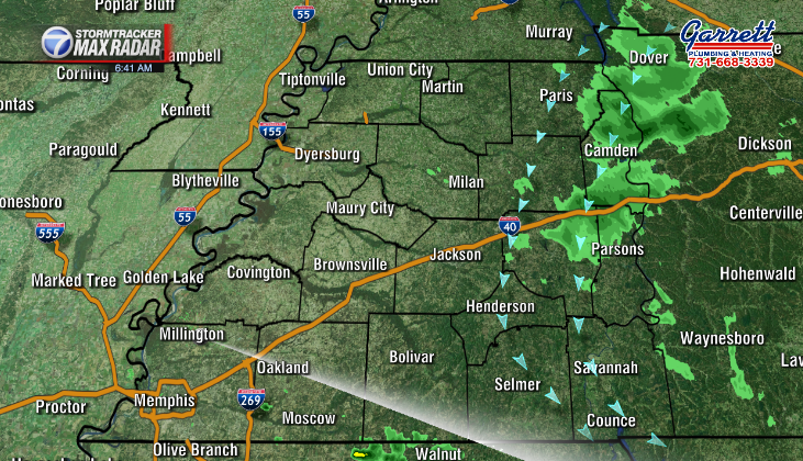
PM Saturday Update Good Evening Everyone, A few lingering storms will be possible tonight mainly before 10 pm. At 7 pm, Stormtracker 7 Radar continued to indicate slow moving storms located near…
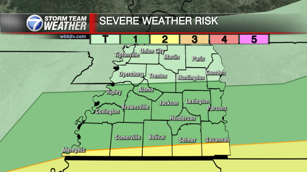
Good Sunday Everyone. Severe storms and flooding continue to be possible into Sunday afternoon as a cold front and area of low pressure dives southward into the region. Primary threats will be damaging wind, large hail, and flooding. Areas most…

WBBJ 7 Forecast Update: Rain showers will return late in the morning Saturday and storms will be likely in the afternoon with gusty winds being the main threat. We are under a…
Friday Weather Update: Good Morning/Early Afternoon everyone as we are seeing some scattered areas of drizzle in and around the viewing area this morning. Becoming partly sunny mid to late morning…
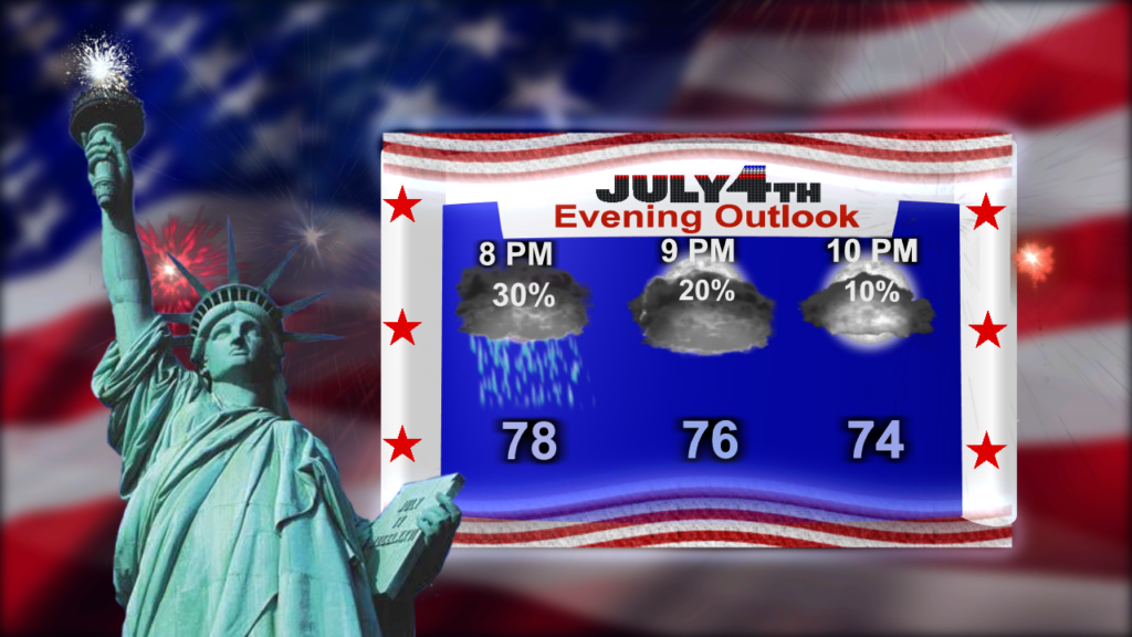
Monday Evening Forecast Update, Monday, July 3rd Good evening everyone... A cold front brought slightly cooler weather to the area today along with lower dewpoints which has been welcomed relief after…

WBBJ 7 Forecast Update: Hopefully you are staying cool West Tennessee! We have seen a heat index between 110-120° so far yesterday. The excessive heat warning has been extended Saturday for all…
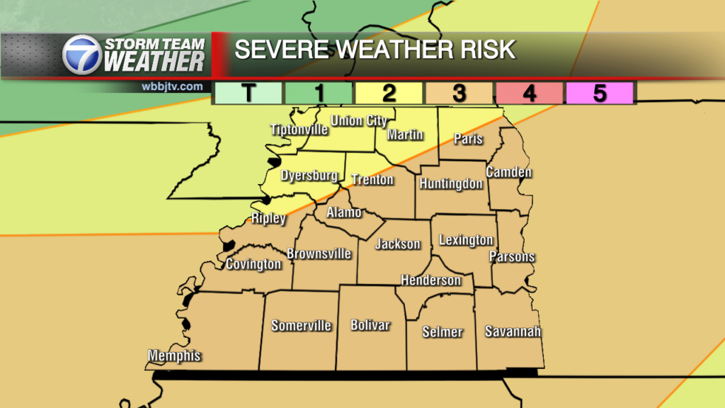
Good Sunday Everyone. Storms will enter the scene later this evening as a trough of low pressure and the associated cold front move closer to us later this evening. A severe threat is increasing for later today so remain weather…
WBBJ 7 Forecast Update: There could be a shower or two this evening but we are not expecting much at all. Saturday will be mostly sunny, hot and dry. The first shot for…
WBBJ 7 Forecast Update Our second official day of summer brings some showers in the eastern counties this morning. Showers will continue moving in from the northeast and move towards the southwest this…

Friday Night Forecast Update for April 28th: A low pressure system and cold front will keep some shower activity around on Saturday but we are not expecting storms. Another front will pass…

Thursday Night Forecast Update for April 27th: A severe thunderstorm watch has been issued tonight in West Tennessee for Shelby and Fayette counties. The threat is for some isolated hail storms producing…

Wednesday Night Forecast Update for April 26th: A low pressure system will move through West Tennessee over the next 36 hours. Rain showers will return after midnight and be heavy at times…

Tuesday Night Forecast Update for April 25th: Conditions will remain beautiful this evening but some clouds will move in tonight. A warm front will linger just south of West Tennessee tonight but…

Weather Update: Friday, April 22 7:06 AM -- Good Saturday Everyone! We are starting out with a thick inversion layer this morning allowing for lots of fog development into the morning with…

Wednesday Night Forecast Update for April 19th: The beautiful Weather continues until Thursday night across West Tennessee. We'll repeat the same weather again for Thursday and add a couple of degrees to the…

Tuesday Night Forecast Update for April 18th: The beautiful Weather continues until Thursday night across West Tennessee. Mostly sunny skies and highs in the low 80s is on the way for Wednesday…

Monday Night Forecast Update for April 17th: We are expecting near picture perfect Spring weather for Tuesday and Wednesday. Most of the day Thursday also looks good, but it will be a…

Saturday Night Forecast Update for April 14th: A severe thunderstorm watch is out until 2am tonight for West Tennessee. Gusty winds will be the main threat. The storms will cross the Mississippi River around 9pm and slowly weaken tonight as…

Saturday Morning Forecast Update for April 15th: A large upper level low will pass just to the north of us later today and an associated and fast moving cold front to bring…

Friday Night Forecast Update for April 14th: We should be dry tonight, the clouds will clear out overnight and expect a sunny start to Saturday. Clouds move back in Saturday afternoon and…

Thursday Night Forecast Update for April 13th: Some light showers are coming up from the southeast tonight into Jackson. The rain is from one of the outer bands of the tropical like…

Wednesday Night Forecast Update for April 12th: Clouds will begin to increase tonight and expect some isolated shower activity on Thursday. The rain chances will decrease on Friday and clear out into…
Tuesday Night Forecast Update for April 11th: Tuesday was another picture perfect day across West Tennessee. If you loved the weather so far this week, you're going to love Wednesday. Sunny skies…

Monday Night Forecast Update for April 10th: After a fantastic Easter afternoon and evening, the nice weather continued into the work week. Sunny skies will stick around until Thursday afternoon. A few…

Saturday Forecast Update for April 8th: The clouds will hang around today, but the sun will begin to return slowly on Easter Sunday to West Tennessee. Highs will be around 60° on…

Friday Night Forecast Update for April 7th: The clouds will hang around tonight and Saturday, but the sun will begin to return slowly on Easter Sunday to West Tennessee. Highs will be…
Thursday Night Forecast Update for April 6th: The front stalled out about 50 miles further north than we had anticipated which kept the rain around longer this afternoon north of I-40.…
Wednesday Night Forecast Update for April 5th: MARCH 31/APRIL 1ST CONFIRMED TORNADO DETAILS: The National Weather Service in Memphis has confirmed 4 STRONG tornadoes in West Tennessee from Friday evening/night and…

Tuesday Night Forecast Update for April 4th: After analyzing the forecast data tonight, it appears to me our tornado threat is low on Wednesday (It isn't ZERO though). A line of gusty…

Monday Night Forecast Update for April 3rd: The National Weather Service is still working on the full report from Friday, but they did confirm an EF3 Tornado near Covington and another one…


