Warm, Cloudy, Humid & Breezy Weather Continues this Week!
Wednesday Night Forecast Update
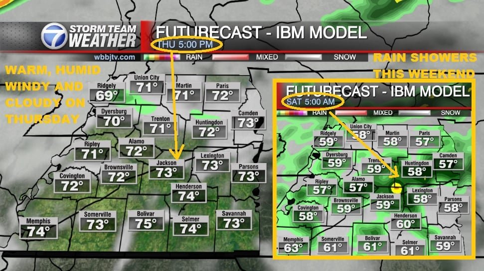
Wednesday Night Forecast for March 9th:
Temperatures reached the 70s for the 3rd day in a row in West Tennessee, but it was mostly cloudy and breezy all day long as well. The humidity increased today and that will keep us warm though tonight. Rain chances will return on Friday and it could be stormy at times this weekend. Catch the latest details and your full hour by hour weekend forecast coming up right here.
TONIGHT:
The humidity sky rocketed today and that will keep temperatures warm all night with the dew point hovering around the mid 50s overnight in West Tennessee. Most of us will only see temperatures falling into the upper 50s. Winds will stay breezy most of the night and come out of the south. Skies will remain mostly cloudy but there will be a few breaks in the clouds at times though.
THURSDAY:
Like Wednesday, we are expecting it to be warm, humid and breezy for Thursday. Highs should reach the low 70s. A few late showers could return overnight into Friday morning, but we are not expecting a lot of rain or much of a storm threat. A few rumbles of thunder cannot be ruled out though into Friday morning. Overnight lows will drop only to the upper 50s.

FRIDAY:
Rain showers will be possible as a storm system will approach the area late in the day. Timing of the rain and strength of the front are still being tabulated by the forecast models though. Highs should reach the low to mid 70s though and expect upper 50s Friday night into Saturday morning.
THE WEEKEND:
Expect mostly cloudy skies all weekend long and rain showers and storms could show up at times. Highs are expected to be in the 60s and as of now, strong storms cannot be ruled out but we will be keeping a close eye on the forecast this week for potential changes to the forecast. Lows should stay in the 50s and winds will change in direction as the storm system lingers over the area. The greatest threat for storms right now appears to be late Sunday into Monday morning for us here in West Tennessee.
DAYLIGHT SAVING TIME:
Don’t forget about setting your clocks ahead one hour Sunday morning. The bad news is we will be losing an hour of sleep. The good news is, we will start to get one more hour of sunshine in the evening.
NEXT WEEK:
Showers should move out by Monday afternoon and we should see decreasing clouds as well. Highs will stay in the upper 60s for the first part of the week in West Tennessee and 70s could be coming back by the middle of the week. The weather will remain spring like and rain chances will show up as the week goes on and possibly some thunderstorms.
Storm Team Chief Meteorologist
Joel Barnes
Facebook: www.facebook.com/joelbarnesweather
Twitter: www.twitter.com/joelbarnes13
Instagram: @joelbarnes13


