Showers And Storms Will Continue Through Tuesday
Saturday Forecast for September 18th:
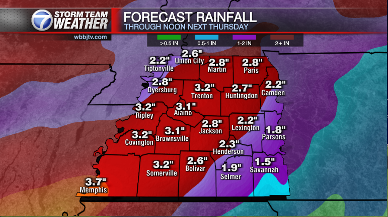
Heavy rain fell in Fayette, Hardeman, Mcnairy, and Chester counties this morning with a with a flash flood warning just south of the area in north Mississippi. *A flash flood watch is in effect for a good portion of the area through 12 am Sunday. A combination of moisture from what was Nicholas and a stalled out cold front at the end of the weekend will lead to slow moving showers and storms capable of flooding. Drier and cooler weather is on the way though as we start fall on Wednesday. Catch the latest forecast and find out if we could be dipping into the 40s next week coming up right here.

THE WEEKEND:
The weekend looks warm, a bit humid and filled with mostly cloudy skies. Saturday looks to bring some morning and afternoon pop up showers and some weak storms expected to develop. Highs will reach the low 80s and lows will down to the mid to upper 60s each morning.

The winds are expected to stay out of the east or southeast and be light in general. Sunday also appears to bring another round of showers and weak storms in the morning and afternoon hours. Chances for rain sit around 60% for both Saturday and Sunday with some locations picking up 1-2″ of total rain over the weekend. Weather forecast models sometimes struggle after a tropical system moves out, so the weekend forecast could change as the time frame gets a little closer. So if you have outdoor plans this weekend, stay on top of the forecast as the week progresses.

NEXT WEEK:
Highs are expected to hang around the low 80s for the start of next week. Showers are expected to remain in the forecast on Monday and stick around into the day on Tuesday as a cold front passes by. Overnight lows are expected to fall down to the upper 60s both Monday and Tuesday mornings. Summer officially ends on Wednesday at 2:21 PM CST. Showers should move out for the first day on Fall on Wednesday but the cooler weather will be filling on it behind the front. The first couple days of fall could be some of the coolest weather we have had in months. Models are trending towards lows down in the low 50s and possibly some upper 40s with highs in the low to mid 70s on both Wednesday and Thursday. Both days though should see plenty of sunshine. Sunny and cooler weather is expected to remain in the forecast for the end of next week and possibly the following weekend.
Brian Davis
Storm Team 7 Meteorologist
Twitter – @Brian7wbbj
Facebook – Briandaviswbbj
Email – Badavis@wbbjtv.com