Cold & Blustery Friday Night, Frost Saturday Morning, Upper 70s on Sunday!
Friday Night Forecast Update
Friday Night Forecast Update for April 8th:
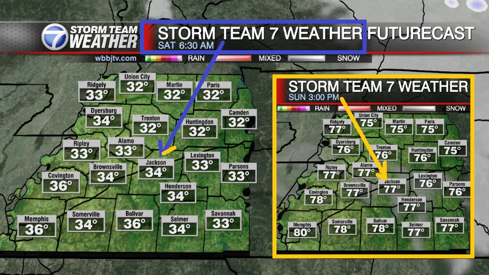
Temperatures will be falling into the 30s after midnight tonight. As the skies clear out by sunrise, low 30s are expected for all of West Tennessee Saturday morning and frost looks likely. Plenty of sunshine is expected on Saturday, but we will not see much of a warm up until Sunday. Breezy southerly winds will allow temperatures to approach 80° for many of us on Sunday. The quiet weather will not last long though as showers and storms will be returning into next week. Catch the latest details on next week’s storm threat, and your weekend forecast coming up right here.

TONIGHT:
Friday night will be the coldest night of the week as well with a chance for some frost to develop with low to mid 30s likely by the start of the weekend. The winds will be quite gusty Friday evening out of the northwest between 15-20 MPH before weakening overnight. Skies will remain mostly cloudy but will gradually be clearing before the sun comes up. The wind chill will be in the 20s at times from midnight until 9 AM Saturday morning.
THE WEEKEND:
Some dry & decent weather is expected to finally return in time for the start of the weekend, but the weather will start out a bit chilly in the low 30s. Frost will be likely Saturday morning for most of West Tennessee, so be sure to take the necessary precautions if you have plants or tender vegetation outside. Saturday afternoon we should see plenty of sunshine but highs will only reach the mid to upper 50s to near 60°.

Like the previous weekend, Sunday appears to be the nicer day. Sunday morning lows will start out in the lows 40s or upper 30s and highs will climb up into the mid to upper 70s by Sunday afternoon. The winds will come out the west on Saturday but shift to the south by Sunday. Mostly sunny skies are likely on Sunday afternoon as well most of the day on Saturday.
NEXT WEEK:
Another storm system will be heading for the Mid South early next week. Some rain showers and storms will be possible from Monday evening through Wednesday. Right now, it is too early to tell who is most likely to be impacted with storms from this system, but rain showers and weak storms will be likely for most of us at least. Highs on Monday will be in the upper 60s and upper 70s will come back on both Tuesday and Wednesday. Both Monday and Tuesday morning are expected to start out in the mid to upper 50s and the winds will come out of the south for the first half of the week. Showers and storm chances are expected to continue into the day on Wednesday, but southerly winds will keep highs in the 70s again and the humidity will stay high as well. The next cold front will pass late Wednesday dropping temperatures some into the day on Thursday. Any lingering showers from the mid week cold front will have moved out by sunrise Thursday morning. The greatest chance for severe weather appears to be late on Wednesday, but that could change as the system gets a little closer.
FINAL THOUGHT:
Spring has officially kicked off here in West Tennessee, but we could see another freeze in the next week or two. We typically get our last freeze around the beginning of April. There will be more chances for severe weather though as we get deeper into Spring. So you need to stay weather aware to changing weather patterns and monitor the forecasts closely. We got you covered in the WBBJ 7 Storm Team Weather Center as always.
For tips on preparing for the storms, click here. To download the WBBJ 7 Weather app, click here.
Storm Team Chief Meteorologist
Joel Barnes
Facebook: @JoelBarnesWeather
Twitter: @JoelBarnes13
Instagram: @joelbarnes13


