Sunny & Mild in West TN. Latest on Hurricane Ian
Wednesday Night Forecast Update
Wednesday Night Forecast Update for September 28th:
Cool, sunny and mild weather will be sticking around for the rest of the work week for all of West TN. We could see a few more clouds and warm up a bit this weekend. Ian could bring some clouds our way but rain isn’t expected. Ian made landfall near Fort Meyers a little after 2 PM CDT with winds up to 150 MPH. The storm has weakened to a category 2 storm again around 10PM on Wednesday Night, but has dumped 15-20″ of rain already in some areas and a lot more is expected over the next 24 hours. We will have the latest on Hurricane Ian and your hour by hour weekend forecast breakdown coming up tonight on WBBJ 7 Eyewitness News at 5.
TONIGHT:
We hadn’t dropped down in the mid 40s since May 8th here in West Tennessee, but we did the last two nights and will again tonight. Some low 40s cannot be ruled out either. Skies will be clear and the winds will be light out of the northeast most of the night. If you haven’t turned on your heater yet, you should be ok again tonight.
THURSDAY:
Temperatures will be a few degrees warmer on Thursday but highs will still only reach the mid 70s and the overnight lows in the 40s streak will continue Thursday night. The winds will continue to come out of the northeast keeping a cool and dry air mass across the Mid South.
FRIDAY:
Depending on how far east Hurricane Ian makes landfall, will determine if we see any showers or clouds from the storm before it moves off to the east of us. The further east you are the better chance you might see some clouds from the storm system. Shower chances are currently NOT expected but cannot be ruled out along the Tennessee River. Highs on Friday will make it into the upper 70s and Friday night lows will drop down to around 50°. The winds will continue to come out of the northeast.
THE WEEKEND:
There is a chance for some cloud cover on the back side of Hurricane Ian, but we also might see sunny skies all weekend long. The storm could drift far enough to the west to bring some rain showers to West Tennessee but that is NOT the current consensus forecast from the storm. We will keep an eye on it as the week progresses, but as of now, impacts look to be minimal here in West Tennessee from Ian. Highs this weekend will make it up to around 80° and lows will fall down to the mid 50s. The winds will continue to come out of the north this weekend, but we should warm back up near or above normal.
TROPICAL UPDATE:
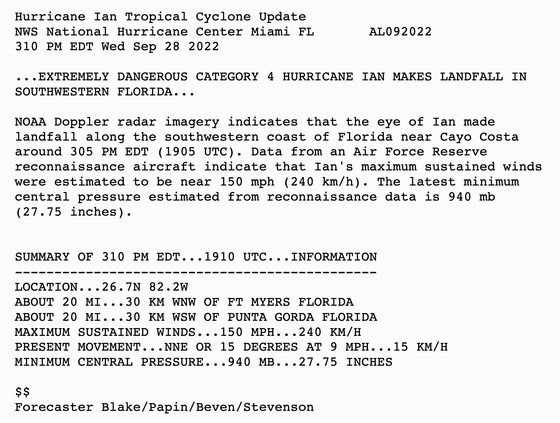
According to the National Hurricane Center… Hurricane Ian made landfall at 2:05 PM CDT near Sarasota Florida as a Category 4 storm with winds up to 150 MPH. The current forecast is suggesting the storm will track to the northeast and slowly weaken over the next 24 hours. The storm will continue northward impacting the coast lines of Georgia and South Carolina before turning to the northwest over the weekend. The storm could bring a few clouds our way but rain showers are not expected as of now. We will continue to keep a very close eye on the storm for any potential impacts to our region, but as of now, that seems unlikely. The next update comes out from the National Hurricane Center will come out tonight at 2am.
Wind gusts were reported over 120 MPH earlier today from the storm just south of Tampa.

Latest Forecast Cone from the National Hurricane Center as of Wednesday evening.

Hurricane Warnings have been issued for both coasts in Central Florida with most of the state and southeast coastlines under Tropical Storm Warnings as well.

Hurricane Ian has been downgraded to a category 2 storm with winds still at 100 MPH. The storm has brought 15-20″of rain across a large swath of West Florida already and a lot more rain is expected to come done still tonight and tomorrow.

Here is a closer look at the highest rain totals as of Wednesday night.

Additional rainfall through Friday morning for Central Florida.

FINAL THOUGHT:
Although we enjoyed a few fall like days during the middle of September, it looks like the last heat wave of the summer is over on September 22nd, just in time for the beginning of fall. Some of the coolest weather since last Spring will be hanging around this week. There will be more chances for severe weather but overall, September is typically low for severe weather development. The tropics have been started out quiet but usually begin to heat up towards the beginning of fall and we are starting to monitor a few systems that could move into the Gulf of Mexico. So you need to stay weather aware to changing weather patterns and monitor the forecasts closely. We got you covered in the WBBJ 7 Storm Team Weather Center as always.
For tips on preparing for the storms, click here. To download the WBBJ 7 Weather app, click here.
Storm Team Chief Meteorologist
Joel Barnes
Facebook: @JoelBarnesWeather
Twitter: @JoelBarnes13
Instagram: @joelbarnes13


