Very Nice Weekend Coming, Record Highs Possible Next Week!
WBBJ 7 Forecast Update:
WBBJ 7 Forecast Update:
The warming trend will continue into the upcoming weekend as southwest winds will stick around for the next few days. Highs may even make it up to record high levels next week before the next cold front comes by. The front will bring our next shot for rain as well which we desperately need. Find out when the front is going to show up and I will let you know if we will be cracking the 80s next week coming up right here.
Drought Concerns Across West Tennessee:
The rain deficit continues to get worse across the Mid South and West Tennessee as most of our viewing area is under an extreme or severe drought. There is some rain in the forecast, it just won’t be here this weekend.

Rain looks to be staying away for the rest of the week as well. We really need the rain badly as drought conditions are becoming extreme across most of West Tennessee. Last month was our second consecutive month seeing only around 1/3 of the total rain we average for that given month. September and October were both very dry months.

We were above normal for the year for rain totals after we wrapped up the month of August. But after the last 8 weeks, we now have a yearly deficit below normal of over 3″. We are going to need a very wet 8 weeks to have our yearly rain numbers climb back up to a normal year.

FIRST FREEZE OF 2023:
Our first freeze in Jackson usually occurs towards the end of October or the beginning over November. Last year our first freeze was early on October 18th but the previous year we didn’t see our first freeze until November 4th. Over the last 10 years, our first freeze has ranged from Mid October to early November. This year, our first freeze was on October 30th. Usually we see our first frost a couple weeks before we see our first freeze, but this year, they both came in on the same night.

TONIGHT:
Friday morning started out in the low to mid 30s but high temperatures in the afternoon made it back up into the mid 60s. The winds were a bit breezy most of the day and came out of the south and that helped warm us up a bit more than we were earlier in the week. The winds will likely be calm overnight into Saturday morning. We are not expecting any rain to fall so you can leave the umbrellas at home. Friday night lows will dip down to the low 40s to kick off your weekend.

THE WEEKEND:
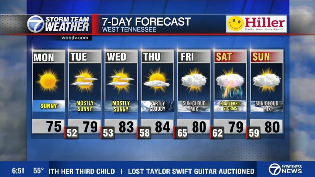
We should warm back up nicely for the upcoming weekend with highs reaching up into the 70s. We should see some clouds increasing as the weekend progresses, but we are not expecting any showers. A cold front will sit just to our north and stall out before it reaches the Mid South. The winds this weekend will start out of the south and transition to the southwest. The front will be pushed back to the north as the weekend goes on allowing temperatures to continue to climb into next week. Morning lows this weekend will be around 40° on Saturday and in the mid to upper 40s for Sunday morning. Rain chances look to increase into the middle and end of next week as the next cold front will get closer and eventually move through.

NEXT WEEK:
Highs next week are expected to be well above normal into the mid to upper 70s to near 80° for most of the week. Eventually a cold front is going to move through but the current timing of the front looks to be late in the work week. The front may get close enough though during the middle of the week to bring some isolated light shower chances. The best chance for rain next week will be when the front moves through and current thoughts are that it will happen on Thursday/Friday. Morning lows next week will hang around into the mid 50s for the most part. We should see plenty of sunshine to kick off the week but clouds will be increasing as the week goes on as well. Winds will stay out of the southwest for the first half of the weekend before changing back to the north behind the front on Thursday.

FINAL THOUGHT:
The first frost and freeze came early this week and it was a very cold day for Halloween festivities. Some warmer weather moved in towards the back half of the work week and will continue into next week. Rain looks to be staying away for the weekend and the first part of next week as well. We really need the rain badly as drought conditions are becoming extreme across most of West Tennessee. The tropics look to be relatively quiet but we are not quite done yet with hurricane season as we are watching a potential storm in the southern Caribbean. We got you covered in the WBBJ 7 Storm Team Weather Center as always.

For tips on preparing for the storms, click here. To download the WBBJ 7 Weather app, click here.
Storm Team Chief Meteorologist
Joel Barnes
Facebook: @JoelBarnesWeather
Twitter: @JoelBarnes13
Instagram: @joelbarnes13


