Another Cold Day With Windchills In The Lower Teens Tonight
AM Monday
A weak upper level disturbance will head our way along with another shot of cold air to arrive late tonight. StormTracker 7 radar continues to show some snow showers over parts of eastern Missouri and northwest Kentucky and some of that limited moisture will move our direction later the evening. A few snow flurries or snow showers will be possible into the evening with no travel problems expected. Skies clear out again late tonight, Lows will drop to around 19 by early morning Tuesday!

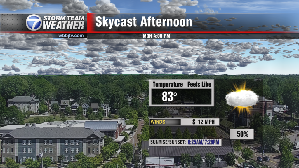
TODAY:
Widespread frost before 10am. Otherwise, increasing clouds, with a high near 42-44. Light and variable wind becoming north northwest 5 to 10 mph in the afternoon. A few spotty areas of snow flurries will be possible into the late afternoon and evening hours.

Bundle up heading out at anytime today as it will feel cold even into the afternoon as northwest winds will pick up around the time our high temperatures peak in the afternoon. The combination of increasing winds and chilly highs in the lower 40s will keep it feeling quite cold at any point.

TONIGHT:
Today is likely to be the coldest day of the cold snap so far. Tonight will start off with mostly cloudy skies early and there will be a few snow flurries possible early as well. Skies will start to clear back out some in the early overnight hours. The overnight low will be in the upper teens, with a light breeze causing a wind chill down to the lower teens, possibly even upper single digits. You will want to bundle up for Jackson’s Christmas parade.

After a bitter cold start in the morning, Widespread frost before 10am. Otherwise, sunny, with a high near 40. Calm wind. Tuesday night, Widespread frost after 7pm. Otherwise, mostly clear, with a low around 24. Calm wind becoming south around 5 mph after midnight. Wednesday, A 20 percent chance of showers after noon. Widespread frost before 8am. Otherwise, increasing clouds, with a high near 52. Southwest wind 5 to 15 mph. Wednesday Night, A 30 percent chance of showers before midnight. Patchy frost after 5am. Otherwise, mostly cloudy, with a low around 36. Southwest wind 5 to 10 mph becoming north northwest after midnight. Another blast of bitter cold arrives in the day on Thursday as highs only climb to around 39 under mostly sunny skies. Thursday night will bring another bitter cold night with lows around 19 with patchy frost and Friday will be mostly clear with highs again only in the upper 30’s. The weekend will bring a warming trend with highs returning to the 50s both days, but a few spotty showers may start out briefly as a little freezing rain late Saturday. Right now it doesn’t look to be a big deal as temperatures will remain above freezing through the weekend. We’ll be watching it closely with updates as we get closer to the weekend.
Stay with the the WBBJ 7 Eyewitness News Team and StormTracker 7 for the latest on your weather as we move towards the Winter season. We’ll have the latest updates online and on air.
Brian Davis

Storm Team 7 Meteorologist
Twitter – @Brian7wbbj
Facebook – Briandaviswbbj
Email – Badavis@wbbjtv.com