Mostly Cloudy Snow Flurries, Cold And Blustery
Weather Update: Monday, March 16 —
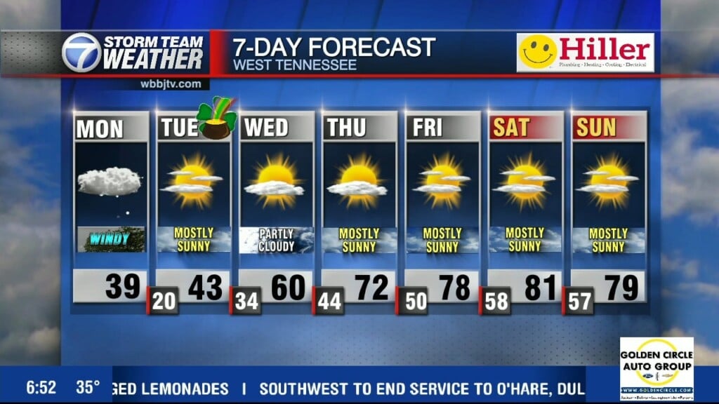
Good Morning West Tennessee. A very cold start to the day with temperatures in the mid 30s this morning. We never actually dropped below freezing this morning, though it certainly feels like it thanks to the icy arctic wind off sub-arctic high pressure to the west. Wind Chill will be hanging out in the 20s all day long. I should also note the wind advisory has been allowed to expire, it will however remain quite blustery today with sustained winds 15-20 mph and gusts around 30-35mph a times. As if that wasn’t enough, wrap around residual moisture will produce snow showers through this morning. You’re not seeing things, its snowing today. It will not accumulate or cause any issues, but flakes in the air will be common, especially if you’re located down wind (southeast) of a local lake or river.

This afternoon, the temperature won’t move much with sub-arctic high pressure and cold air draining into the region through the day. High will be around 38°F. Clouds will start to break after noon today, allowing sunshine, though temps won’t respond. It will be setting the stage for the true villain of this week’s story and that is radiational cooling tonight. Temps will fall off the cliff after sunset likely and easily passing the current record low for St. Patrick’s Day of 25°F/1962. Low around 18-20°F.
Storm Team Meteorologist
Moe Shamell
Facebook: www.facebook.com/mshamellwbbj
Twitter/X: @WBBJ7Moe
Instagram: @moeshamell