TORNADO WATCH Until 11PM Tonight, More Storms Overnight and Tuesday Evening
WBBJ 7 Forecast Update
WBBJ 7 Forecast Update:
A PDS (Particularly Dangerous Situation) TORNADO WATCH has been issued until 11pm tonight for all of West Tennessee. Storms will begin to fire up over the next couple hours in our area. Scattered Supercells are expected and a tornado could develop with any supercell that goes up as well as up to baseball size hail. As the evening goes on, the tornado threat will decrease but the storms will become more widespread and still be intense with strong winds highly likely. PLEASE stay weather aware tonight, this is a very dangerous situation tonight!

THIS WEEK:
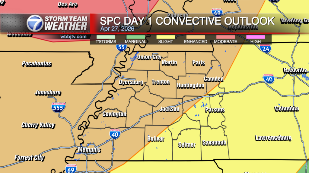
Over the last 24 hours short range forecasts models continue to hint at the chance for a couple supercell rotating storms to develop in West Tennessee sometime between 5pm and 10pm. These supercells will exist in a very favorable environment for tornadoes through the afternoon and evening, and multiple strong to intense tornadoes (EF-2/3+) appear likely, especially from parts of MO into IL along/near the effective front. This strong tornado threat may also extend farther south into AR/TN, but confidence is somewhat lower with southward extent due to weaker large-scale forcing.

By early evening, convection will probably tend to consolidate into clusters capable of producing numerous to widespread damaging winds from the mid MS Valley eastward into the lower OH Valley, before eventually weakening tonight as instability gradually decreases. A threat for QLCS and embedded supercell tornadoes will persist through much of the evening and early overnight hours as well given strong low-level shear forecast.

Overnight lows will fall down to the mid 60s and the winds will be pesky all night long out of the southwest between 10-20 mph. Expect clouds to stick around all night long too. By the morning on Tuesday we are expecting these storms to wrap up and we should get a decent break in the middle of the day on Tuesday. Tuesday will be warm and humid again with highs reaching the low 80s and the winds staying out of the south. Some sun may peak through as well. More storms are expected after 4pm and will come in waves in the evening and overnight hours. More severe weather looks likely at this time for many of us in West Tennessee. The storms should wrap up by Wednesday morning as the cold front passes by.

Wednesday will be cooler behind the front. Morning lows will start in the low 60s but highs will only make it up to around 70° in the afternoon. The clouds will move out during the day as well. The winds will come out of the north and will stay out of the north for a few days. Wednesday night lows will fall down to around 50°. Thursday is going to be a mostly cloudy day but we should be dry. Highs will only reach up to around 70° again due to the northerly winds. Thursday night as well will fall down to around 50°.
Another weak front is coming in on Friday and will bring another round of showers with it. Storms are not expected at this time, well at least, any strong storms on Friday. Most of us will see some showers though as the front passes by. Highs on Friday will reach up to the mid to upper 60s depending on the timing of the front. Friday night will be a bit chilly with lows dropping into the mid 40s to kick off the weekend.
THIS WEEKEND:
Dry weather is expected this weekend and it will be quite Spring-like. It will not be too hot and will be a great weekend for outdoor chores or activities. Highs on Saturday will reach the upper 60s and low 70s look to be in on the way for Sunday. Saturday morning will be in the mid 40s but we could fall into the low 40s on Sunday morning. A frost of a freeze though is not expected although it might be cool enough that you will need to turn on your heater. Sunday night lows will fall down to around 50° and be a little warmer as southerly winds will move back in late in the day on Sunday. Saturday the winds will stay out of the north, but turn to the west on Sunday and to the southwest by Sunday night. Expected plenty of sunshine this weekend although some clouds could be lingering around on Saturday morning from Friday night’s cold front.
Storm Team Chief Meteorologist
Joel Barnes
Facebook: @JoelBarnesWeather
Twitter: @JoelBarnes13
Instagram: @joelbarnes13