More Scattered Storms This Weekend
[gtxvideo vid=”Dx69ul6b” playlist=”” pid=”wMQlYtLM” thumb=”http://player.gtxcel.com/thumbs/Dx69ul6b-120.jpg?cachebust=1464322685071″ vtitle=”Weathercast 10PM.flv”]
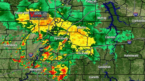
Weather Update – 11:15 p.m. Thursday
Though the bulk of the shower and thunderstorm activity is weakening, there is still some heavy rain falling that could lead to flash flooding. Overall motion is for these showers to travel northeast overnight before dissipating after midnight. We could still see a few showers early Friday morning near the Mississippi River. Temperatures will only drop to the middle and upper 60s again at the coolest point of the night.
FRIDAY
More scattered showers and thunderstorms will be possible tomorrow, especially for parts of West Tennessee near the Mississippi River. There is a 40% chance for rain tomorrow with a small possibility for one or two storms to become severe. With the recent and incoming heavy rain, there’s also a potential for localized heavy rainfall to lead to flash flooding once again.
THIS WEEKEND
Skies will be mostly cloudy on Saturday but clearer on Sunday. Temperatures will warm up through the weekend as a result with a 40% chance for rain on Saturday, 20% on Sunday, and 20% on Memorial Day. Stay weather aware this weekend as we’ll continue to see a chance for pop-up showers and thunderstorms.
Stay with the VIPIR 7 Storm Team for the very latest updates to this forecast.
Tom Meiners
Storm Team 7 Chief Meteorologist, CBM
Twitter – @WBBJ7TomMeiners
Facebook – facebook.com/WBBJ.tom.meiners
Email – tmeiners@wbbjtv.com