Drought Busting Type System on the Way Early Next Week
WBBJ 7 Forecast Update
WBBJ 7 Forecast Update:

A few places in West Tennessee saw some light rain today and we will pick up another shot on Friday as a cold front is going to pass through. We are not expecting much for rain from that system but the following one coming in early next week, looks a lot more promising in the rain department. Warmer and more humid weather will look to return on Thursday. There looks to be a potential drought buster type system coming next week and we will have all the glorious details coming up right here.
TONIGHT:
Our first shot for rain this week showed up on Wednesday. We didn’t see much if any rain but the folks south of Jackson did see some light showers early in the afternoon. Places north of Jackson didn’t see much of anything more than a trace of rain or a few sprinkles. Skies were mostly cloudy in the afternoon on Wednesday but we did see some sun in the morning. Highs on Wednesday reached the mid to upper 60s with overnight lows dropping down to around 50°. The winds turned to the southeast late in the day on Wednesday and will be calm tonight.

THURSDAY:
Thursday will be a bit more humid than earlier in the week due to the southerly winds. This will keep our overnight temperatures above normal. Due to the clouds sticking around most of the day, highs will only reach the upper 60s again but some low 70s will be possible. Shower chances look to stay away on Thursday as overall dry conditions are expected. There will be a better chance for some rain on Friday. Thursday night lows will be warm and fall down to the mid 50s from the cloud cover and the slight increase in the humidity.

FRIDAY:
The low pressure system near New Orleans is not going to move much this week but it will begin to move to the northeast on Friday. As it moves out some light showers are expected to try to move on in as a weak front is going to pass by. That will also bring a shot for a few showers into the afternoon hours. We are not expecting severe weather or any storms from the front as of now. Friday will be our best shot for rain this week but it would be surprising if anyone saw more than 1/4″ from the weak front. Chances for rain sit at 60% as of now. Friday highs are forecast to reach the mid to upper 60s and Friday night lows will fall back down to the upper 30s behind the cold front. Any chances for rain will clear out before the sun comes up to kick off the weekend.

THE WEEKEND:
We are expecting a cooler, rain free and mostly sunny weekend for the most part across West Tennessee. The winds will come out of the north on Saturday behind the front and will look to shift to the east as we get going into the day on Sunday. Highs on Saturday will reach the upper 50s and we should warm back to the low 60s on Sunday. Saturday night will be cool with Sunday morning looks to start out in the mid to upper 30s. We will likely stay above freezing though this weekend. Rain chances will try to return Sunday night and could get heavy at times into Monday morning. Early next week the winds will shift back to the southeast allowing us to warm back up near normal by Monday.

NEXT WEEK:
We have some really good news it looks like to kick off next week. The most rain we have seen in over 3 months looks to be on the way from Sunday night, all day Monday and into Tuesday afternoon across West Tennessee. All long term forecast models are showing at least an inch of rain coming in for most of us with some locations seeing over 2″ during a 36 hour period as a low pressure system will slowly move across the region. Highs next week will be cool in the 50s and behind the front, we will see temperatures dip back down near freezing on Wednesday morning. The winds will vary in direction early in the week around the low pressure system. This system could bring some storm activity but we are expecting the severe weather to stay south of West Tennessee at this time.

FINAL THOUGHT:
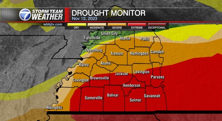
The first frost and freeze came early in November and we had record highs the following week. Seasonable weather looks to return for this week across West Tennessee. There are a few chances for rain this week but overall things are looking bleak in the rain department until early next week when a drought busting type system looks to be on the way. We really need the rain badly as drought conditions are becoming extreme across most of West Tennessee.
For tips on preparing for the storms, click here. To download the WBBJ 7 Weather app, click here.
Storm Team Chief Meteorologist
Joel Barnes
Facebook: @JoelBarnesWeather
Twitter: @JoelBarnes13
Instagram: @joelbarnes13


