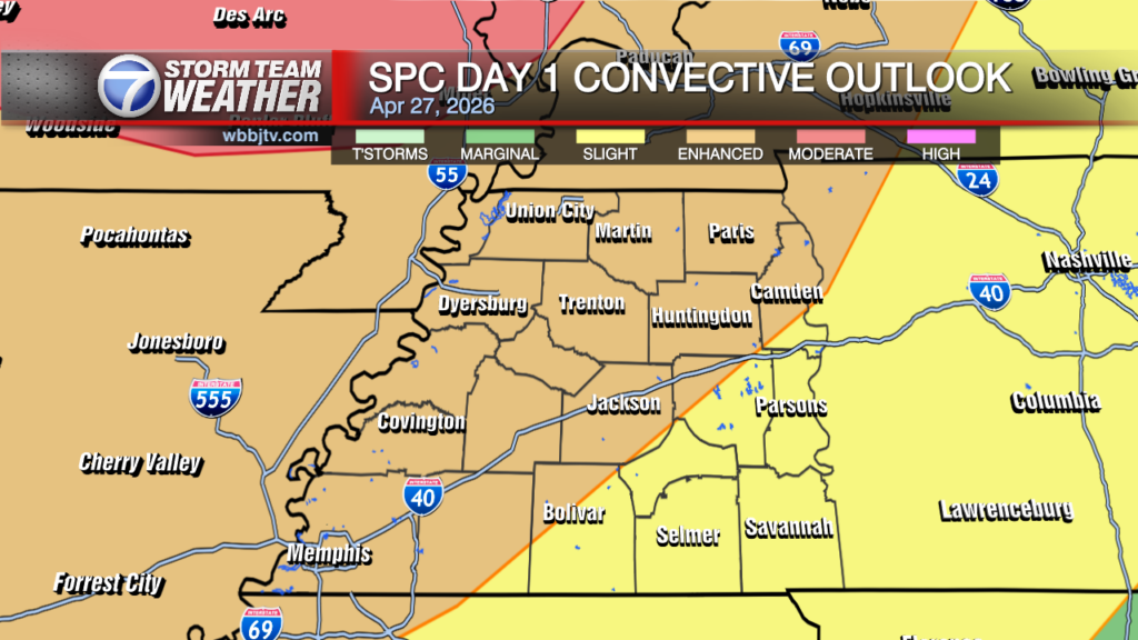
A High To Moderate Risk For Severe Weather Today
Thursday Morning Forecast for March 25th:
*Severe Weather Likely In The Afternoon Today With Potential For Large Hail And Tornadoes*
Our 2nd significant storm threat this season will be here on Today. Our area is now upgraded to a high to moderate risk of severe weather ranging around 5 of 5 near the Tennessee River to 4 of 5 in the rest of West Tennessee.
This storm system is eerily similar to last week’s storm that spawned 20 tornadoes in Alabama, however, forecast models have this system tracking a little further north then last week.
This could increase the tornado threat this go around for us. The timing of the most likely tornado threat appears to be between 2-7 p.m. for our area. We should be wweather aware through today as we could get a severe storm in the morning but again, the afternoon and evening will be the highest chance for a numerous severe storms and a tornado threat.
Strong storms are also likely to move into West Tennessee early Thursday morning. Some could be severe, but the most concerning threat for Tornadoes, Large Hail and Extreme Winds will be in the afternoon.
Portions of West Tennessee have been upgraded to a HIGH risk today. We will keep monitoring the forecast models as we get them in the Storm Team Weather Center and will bring you the latest details right here.

TODAY:
Mostly rain showers and some weaker non-severe storms are expected for the first part of the day, but we should get a break between the late morning and early afternoon.
Expect cloudy to mostly cloudy skies all day. Winds will be breezy at times and come out of the south. Highs should reach the low 70s in the afternoon. Some stronger storms and likely some severe weather will show up Today during the afternoon and evening time frame.
Here is a look at the timing of the storms betwenn 2-7 p.m. All the main models are slightly different but all agree on severe storms possible in the afternoon.


5PM

6PM

7PM

Some locations south of I-40 have been upgraded to a high risk for severe storms, which hasn’t happened in several years for West Tennessee.
This is a significant threat and you need to stay weather aware and watch the forecast closely over the next couple of days.

Flash flooding could become an issue in some areas south of I-40 as well so we will be keeping a close eye on that situation as well. 2-4 inches of rain will be possible in some areas that are hit with multiple storms on Thursday.

FRIDAY:
Friday will be a bit cooler behind the cold front and highs will make it into the mid to upper 60s. But we should see plenty of sunshine and the winds are expected to come out of the west. It should be a dry finish to the work week and start to our weekend.
THE WEEKEND:
Severe weather will again be possible Saturday as we are now under a slight risk for Saturday or 2 of 5. A few showers will linger into Sunday but We should see plenty of sunshine as well at times this weekend as well.
Highs will climb into the mid 70s on Saturday, but should be about 10 degrees cooler on Sunday, behind Saturday night’s storm system. Thunderstorms could be possible as the system tracks across West Tennessee, but it is too early to tell or have high confidence in the forecast as of now as far as severe weather concerns.
FINAL THOUGHT:
We are now officially in Spring and starting to get closer to our peak severe weather season. So you need to stay weather aware to changing weather patterns and monitor the forecasts closely. We got you covered in the WBBJ 7 Storm Team Weather Center as always.
For tips on preparing for the storm, click here. To download the WBBJ 7 Weather app, click here.
Storm Team Meteorologist
Brian Davis
Facebook: @Briandaviswbbj
Twitter: @Brian7wbbj
Email: Badavis@wbbjtv.com


