Rain Tonight Into Thursday Morning, Drier Weather Friday
Wednesday Night Update
Good Wednesday Everyone!
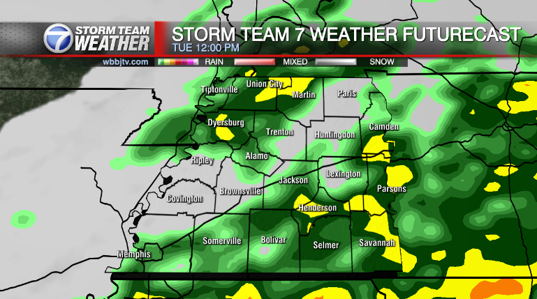
The cold front that brought up to 4 to 5 inches of heavy rain in parts of the viewing area moved south last night and stalled out near the Tennessee River. The stalled out frontal boundary will continue to produce scattered areas of showers and a few storms overnight and into mainly the first half of Thursday.

Due to the stalled out and slow moving system, We have picked up some impressive rainfall totals over the last 36 hours with some doppler estimates up to 5 inches in some of our western counties.

…And the rain is not over yet as additional pockets of heavy rain will develop late tonight into the morning hours of tomorrow.

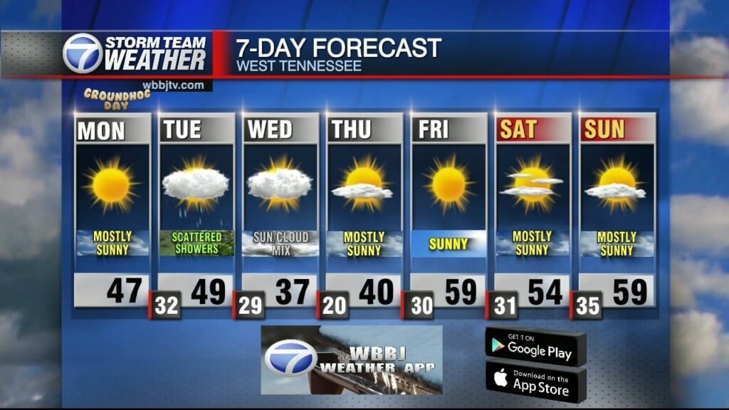
TONIGHT:
Additional rounds of scattered showers and a few weak thunderstorms likely with lows around 61 and light north winds around 5 mph.
THURSDAY:
Scattered showers and a few storms into the morning and then mostly cloudy for the afternoon and evening. Highs in the mid to upper 60s and light and variable winds around 2 to 5 mph. Thursday night looks dry with mostly cloudy skies and lows in the mid 50s and light northeast breezes around 5 mph.
FRIDAY:
Friday looks to be a dry day with partly sunny skies and highs near 72.

THE WEEKEND:
A rainy weekend looks to be on tap with a good chance of rain both Saturday, Saturday night, and Sunday. Highs in the lower 70s both days.

We are continuing to monitor the latest on Hurricane Rafael. As of Wednesday Evening, Rafael has weakened some due to crossing the land areas just west of Havana Cuba. Before crossing over Cuba, Rafael had strengthened to a category 3 system with 115 mph winds and had weakened slightly after moving over Cuba to a category 2 storm with winds of 105 mph. Here is the forecast path and track of hurricane Rafael.

Veterans Day looks like our next break in the rain with mostly sunny skies and highs in the lower 70s. Another more powerful system looks to be coming our way around Wednesday of next week, bringing back some heavy rain and windy conditions but right now, models indicate a cold air blast behind the system for a colder end of next week.
Brian Davis
Storm Team 7 Meteorologist
Twitter – @Brian7wbbj
Facebook – Briandaviswbbj
Email – Badavis@wbbjtv.com