Hurricane Ida Makes Landfall
Sunday Evening Update
Sunday Evening Forecast Update for August 29th:
Hurricane Ida made landfall near Port Fourchon, Louisiana, shortly before 12 p.m. CT Sunday as an extremely dangerous, Category 4 hurricane with winds of 150 mph. Ida, striking on the 16th anniversary of the historically devastating Hurricane Katrina, tied as the state’s most powerful storm ever with Laura from last year and the Last Island Hurricane of 1856.

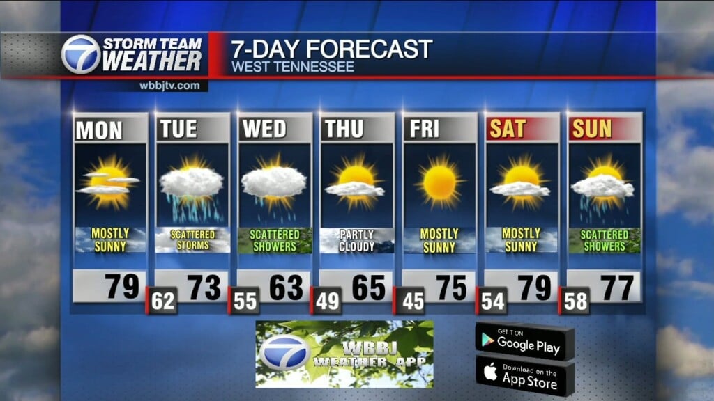
Nice and pleasant weather will continue to stick around for most of the day today. Heavy rain and gusty winds from Hurricane Ida will move into West Tennessee Monday and get worse on Tuesday before moving out on Wednesday. Winds could gusts as high as 30-40 MPH and 2-5″ of rain is expected. Cooler and mild weather will return for the back half of next week. Catch the latest forecast cone for Hurricane Ida and the rest of your forecast coming up right here.

HURRICANE IDA:
Confidence is high that Ida will impact West Tennessee for the first half of next week. Heavy rain could lead to some flash flooding and winds are expected to be sustained between 15-25 MPH with gusts as high as 35-40 MPH from Monday afternoon until Wednesday morning.

As of 6:45 PM, Ida was still a very strong category 3 storm with winds sustained at 125 mph. Ida has been bearing down on Louisiana now for over 6 hours now with winds of 120 to 140 mph. In the last hour had finally started showing some sign of weakening.

Here are the latest on Ida which continues as a major hurricane because it takes a long time to weaken over the very flat and low land in which it is encountering. As Ida moves in to slightly more terrain and higher elevated land north, it will continue to slowly weaken.

TODAY:
Skies will start out sunny on Sunday but clouds will increase as the day goes on. Highs will make it up near 90° and the heat index will again climb to the mid to upper 90s again in the afternoon. A few afternoon showers and evening storms will be possible but chances only sit around 20%-30%. Rain chances will increase some overnight but the bulk of the rain will hold off until after the sun comes up Monday morning.
MONDAY:
Clouds will move in thick early on Monday and the rain showers are expected to follow as the morning goes on. Rain will move up from the south into the afternoon and by Monday evening all of West Tennessee should be dealing with rain activity from Ida. Highs will reach the mid 80s before the heavier rain bands shows up and the winds will be out of the east most of the day between 10-15 MPH with higher gusts starting in the afternoon and evening hours. 1-2″ of rain can be expected on Monday.

If there is better news with this then it is that it looks like Most of Ida’s power will be just to our east as we will be on the left of the former eye wall circulation but windy and rainy conditions will prevail long term for several hours. North Alabama and East Tennessee will likely deal with more of a tornado threat as they will be on the right of the circulation.

TUESDAY:
Cloudy skies, rainy conditions with gusty northeast winds are likely for the entire day on Tuesday. Highs will only reach the mid to upper 70s under the thick clouds and heavy rain showers. Some embedded thunderstorms will be possible and although our tornado threat is overall quite low, some rotating storms could spark up as Ida moves through the region. Additional rainfall amounts between 2-4″ will be possible in some locations on Tuesday. Winds could gusts as high as 35-40 MPH with the storm system.

WEDNESDAY:
Rain showers and breezy winds will stick around for the first half of the day on Wednesday but should begin to clear out in to the afternoon. Highs will reach the low 80s if we pick up some sunshine in the evening hours but if the clouds stick around until sunset, we will most likely stay in the 70s again. Winds will come out of the northwest and start out between 10-15 MPH and weaken as the day goes on. Up to an additional inch of rain could be possible for the first half of the on Wednesday.

LATE NEXT WEEK:
Sunny skies, cool and mild weather will move in for Thursday and Friday. Highs will reach the low to mid 80s and morning lows will fall into the low to mid 60s. Rain showers are not expected and the winds will stay out of the north behind Ida as she moves to the east and away from West Tennessee.
FINAL THOUGHT:
Not only are we now officially in tropical storm season, we are still in the middle of our severe weather season. So you need to stay weather aware to changing weather patterns and monitor the forecasts closely. We got you covered in the WBBJ 7 Storm Team Weather Center as always.
For tips on preparing for the storms, click here. To download the WBBJ 7 Weather app, click here.
We’ve got you covered today with team coverage and online updates with
Storm Team Chief Meteorologist
Joel Barnes
Facebook: @JoelBarnesWeather
Twitter: @JoelBarnes13
Instagram: @joelbarnes13
Brian Davis
Storm Team 7 Meteorologist
![]()
Twitter – @Brian7wbbj
Facebook – Briandaviswbbj
Email – Badavis@wbbjtv.com