
Storm Threat Returns Wednesday Evening to West TN!
Wednesday Night Forecast Update for January 18th: The gusty rain storms are beginning to move out of West Tennessee and just some good ole fashion rain will continue for a couple more…
Wednesday Night Forecast Update for January 18th: The gusty rain storms are beginning to move out of West Tennessee and just some good ole fashion rain will continue for a couple more…

Tuesday Night Forecast Update for January 17th: It has been a wonderful Tuesday for most of West Tennessee with highs up near 70°. The humidity will increase tonight and that could lead…

Make sure to take an umbrella and/or rain jacket with you as you head out today! Rainy & cloudy day all across West Tennessee. Showers will last all day into early tomorrow eventually clearing out by Sunday afternoon. Highs in…

Monday Night Forecast Update for January 2nd: The NWS in Memphis has issued a tornado watch tonight for sections of West Tennessee. I think we will see some gusty storms as the line goes by, but I think the tornado…

Thursday Night Forecast Update for December 22nd: We picked up a widespread 1-2" of snow so far across West Tennessee. Most of the snow is now moving east of Jackson and will…
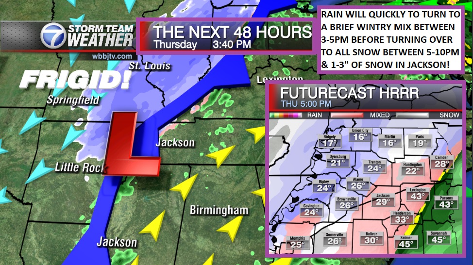
Wednesday Evening Forecast Update for December 21st: A wind chill warning and a winter weather advisory have been issued for all of West Tennessee. Feels like temperatures will plummet Thursday evening well…

Tuesday Night Forecast Update for December 20th: The feels like (wind chill) temperature is going to drop from 40° around 4 PM on Thursday to -20° by midnight. That is a 60°…

Monday Night Forecast Update for December 19th: We have a couple days to prepare but the coldest Christmas weather since the 1980s looks to be heading our way. Temperatures will drop around…

Friday Night Forecast Update for December 16th: Morning lows will fall to the upper 20s tonight and highs will only reach the low 40s this weekend. We can't rule out a shower…

Monday Night Forecast Update for December 5th: Temperatures are slowly warming up tonight as southerly winds are increasing the moisture across West Tennessee. We should be around 60° in the morning and…


