Severe Storm Threat Back Tuesday, Nice Weather for Late Week Parades
WBBJ 7 Forecast Update
WBBJ 7 Forecast Update:
The next storm system is approaching from the west tonight and will bring a few rounds of showers and storms back to the Mid South. The first round is coming in on Tuesday morning. The showers and storms will likely impact some people’s morning commute. A severe storm or two will be possible but the main concern from the system appears to be coming Tuesday night. The storms are expected to move through from sunset to sunrise. As of now, the storms are forecast to cross the Mississippi River between 9-11pm and exit the Tennessee river between 1-3am. Gusty winds appear to be the main threat but the SPC is hinting at a low tornado threat as well. The further west you are, the more likely you are to encounter severe storms. More showers and storms could linger during the first half of the day on Wednesday as well. Catch the full forecast, including a look at the upcoming parade forecasts coming up here.

THIS WEEK:
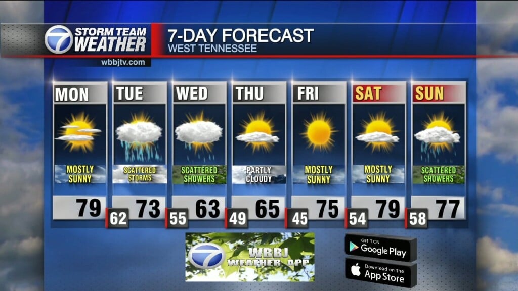
We are expecting a quiet and mild night across West Tennessee. Overnight lows will dip down to around 60°. The winds will stay a bit breezy and come out of the south. That will increase the humidity, keeping it a bit muggy tonight. Clouds will increase as the night goes on. The next shot for storms is coming to West Tennessee on Tuesday. There will be some storms and pockets of heavy rain in the morning but we should get a break in the afternoon and evening hours. After the sun goes down, the main event is going to start as a line of gusty winds storms will look to move through. Some severe storms will be possible but the storms are forecast to weaken as they move to the east into the overnight hours. Highs will reach the mid 70s, the winds will stay out of the south and expect mostly cloudy skies. Tuesday night lows will drop to the mid 50s.

There will be some lingering showers and possibly some storms on Wednesday as well in the morning. There could be some additional redevelopment in the afternoon but if that happens, most if not all the activity will be south and east of us. Highs will reach the mid 60s on Wednesday and the skies will clear on Wednesday night allowing lows to fall down to the upper 40s to kick off our Thursday. Rain chances are 90% on Tuesday but are only 40% on Wednesday. The winds will shift to the north during the day and stay that way through Thursday.

Thursday and Friday are looking great for the Strawberry festival parades. Thursday is going to be a bit cooler than Friday but both days should see plenty of sunshine. There might be a few more clouds on Thursday and the winds on Thursday will come out of the north before transitioning to the south on Friday. Highs on Thursday will only reach the low to mid 60s but highs will reach up to the mid 70s on Friday. Thursday night will get a bit cool dropping into the mid 40s but Friday night will only drop to the low to mid 50s due to an increase in moisture from the southerly winds.

MOTHER’S DAY WEEKEND:
Unfortunately storms are expected to impact our Mother’s Day plans for many of us in the Mid South including us here in West Tennessee. Saturday is looking like a really nice day with mostly sunny skies and highs making it up to around 80°. The winds will come out of the west on Saturday and back to the southwest on Sunday. Sunday we should reach the low 80s before the storm chances start. There is plenty of uncertainty of the timing and strength of the Mother’s Day system, but we will for sure need to keep an eye on the forecast as the weekend gets closer. Overnight lows will fall down to around 60° both weekend nights and some of the storms could continue into Monday next week.
Storm Team Chief Meteorologist
Joel Barnes
Facebook: @JoelBarnesWeather
Twitter: @JoelBarnes13
Instagram: @joelbarnes13