
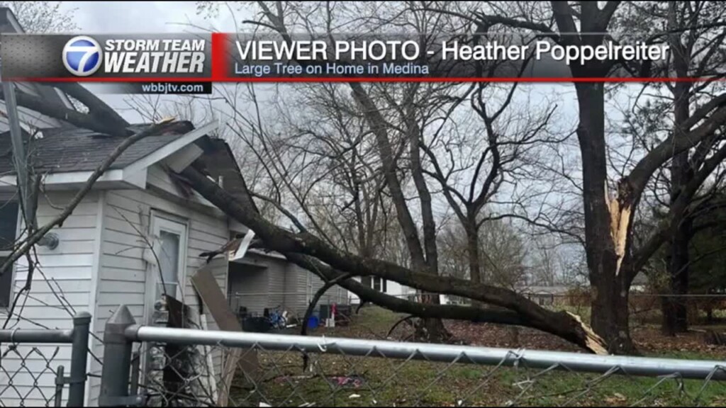
Tornadoes Leave A Path Of Destruction, Calmer Weather Ahead
Saturday April 1st **WIND ADVISORY UNTIL 1 PM TODAY** Winds will gust up to 35 mph at times. Winds should diminish by the evening for calmer weather ahead the rest of…
Saturday April 1st **WIND ADVISORY UNTIL 1 PM TODAY** Winds will gust up to 35 mph at times. Winds should diminish by the evening for calmer weather ahead the rest of…

Friday Evening Forecast Update for March 31st: It has been over a decade since sections of West Tennessee have been put under a high risk (5/5) for tornadoes. The last PDS Tornado…

Thursday Night Forecast Update for March 30th: A concerning storm set up will be in place across West Tennessee Friday evening. This is the most concerning storm set up since I have…

Wednesday Night Forecast Update for March 29th: Temperatures will be a bit chilly again tonight falling down to the upper 30s. Mostly sunny skies and warmer weather is expected Thursday. Storms and…

Tuesday Night Forecast Update for March 28th: Overnight temperatures will fall down near freezing tonight and a round of frost looks likely. Please bring in or cover any delicate plants to protect…
Weather Update, Monday, March 27th: A weak disturbance will move through the area overnight and into early Tuesday bringing a slight chance of a quick shower mainly before 9 am on…
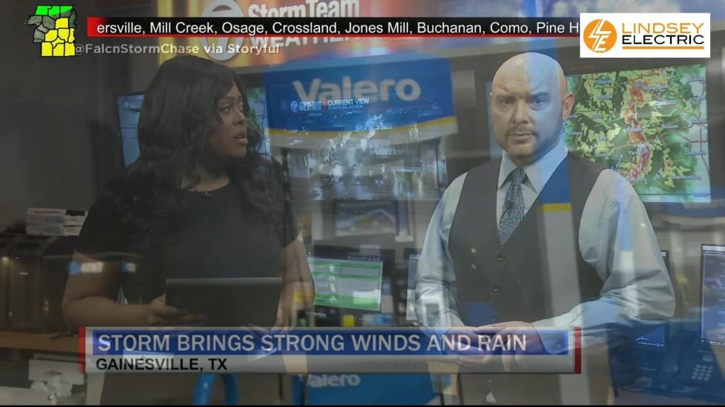
Friday Night Forecast Update for March 24th: TONIGHT: The showers will move out into the early morning hours across West Tennessee. The winds will be gusty at times and continue out of…
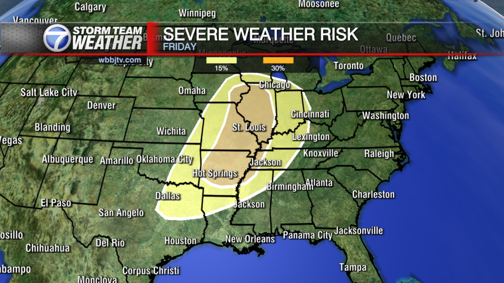
Thursday Night Forecast Update for March 23rd: Here is an hour by hour breakdown of what you can expect where you live on Friday evening/night as the next storm system moves through.…

Wednesday Night Forecast Update for March 22nd: The showers have cleared out and it will be a nice evening and night across West Tennessee. Thursday will be mostly dry, warm and humid.…

Tuesday Night Forecast Update for March 21st: Strong evaporative cooling has lead to some isolated sleet and graupel pockets this afternoon across West Tennessee. A stalled out warm front will slowly lift…

Monday Night Forecast Update for March 20th: We tied the record of 21° Sunday morning and it was even colder this morning as we dropped down to 17° to start our…

Saturday Morning Forecast Update for March 18th: A freeze warning continues until 9 am this morning and returns again at 10 pm tonight until 11 am Sunday. Highs this weekend will only…

Friday Night Forecast Update for March 17th: A freeze warning has been issued tonight and we are likely to drop below freezing for the next 4 nights. Highs this weekend will only reach the 40s and some of us will…
Thursday Night Forecast Update for March 16th: We are not expecting severe weather or even any strong storms tonight in West Tennessee. We could see a few lightning strikes or hear some…

Wednesday Night Forecast Update for March 15th: We dropped down to the low 20s this morning in Jackson beating a 35 year old record. Southeast winds warmed us up a bit this…

Tuesday Night Forecast Update for March 14th: Another freeze warning remains in effect tonight as all of West Tennessee will likely drop into the mid 20s again. Please take necessary precautions with…

Monday Night Forecast Update for March 13th: As the skies clear out tonight and the winds weaken temperatures will fall down into the upper 20s. A freeze warning is in effect from…

Saturday Morning Forecast Update for March 11th: *Don't Forget To Spring Forward Tonight As We'll Set The Clocks Forward One Hour* Increasing cloudiness today with showers entering the picture in the mid afternoon. A few weak storms in the picture…
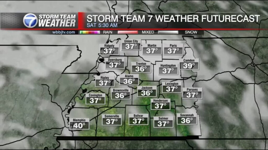
Friday Night Forecast Update for March 10th: Here is a look at the futurecast through the weekend for all of West Tennessee. Some frost will be possible tonight, rain showers will return on Saturday and a some storms will mix…
Thursday Night Forecast Update for March 9th: A weak front is moving through West Tennessee and will push the rain out tonight and the clouds out by Friday afternoon. Most of the…

Wednesday Evening Forecast Update for March 8th: More rain will hold off until around sunrise Thursday and a few weak storms will be possible along the Mississippi border in the afternoon and a few lingering in the late evening as…

Tuesday Night Forecast Update for March 7th: It was a little cooler Tuesday behind last night's cold front, but we were still well above normal for this time of the year. Clouds…

Monday Night Forecast Update for March 6th: A weak front will pass by tonight but it looks like a dry front. Highs will still reach the mid 60s on Tuesday staying above…

Saturday Forecast Update for March 4th: Winds gusted over 60 MPH Friday in Madison and Gibson county for several hours and left a huge swath of damage across the area. From trees,…
Friday Night Forecast Update for March 3rd: Winds gusted over 60 MPH today in Madison and Gibson county for several hours and left a huge swath of damage across the area. From…
Thursday Night Forecast Update for March 2nd: Non severe storms producing heavy rain, plenty of lightning and 30 MPH wind gusts are moving through West TN between 11pm-1am. They will move through…

Wednesday Evening Forecast Update for March 1st: We are still tracking some gusty storms in Hardeman, McNairy and Hardin counties during the 7PM hour and a few stronger and rotating storms are continuing tonight in Arkansas. Those storms are…

Tuesday Night Forecast Update for February 28th: After the nicest day of 2023 so far for our Tuesday to wrap up February, rain showers and storms will be returning from Wednesday afternoon…

Monday Night Forecast Update for February 27th: We had winds gusting up to 45 MPH across West Tennessee this afternoon, but the winds will weaken tonight. Tuesday will be mostly sunny warm…

Welcome in to a sunny but windy afternoon. A wind advisory will continue until 4 pm. Winds will calm some into the evening and skies will remain mostly clear into the evening…
Saturday Forecast Update for February 25th: Mostly cloudy skies and off and on rain showers will continue though Monday morning across West Tennessee. A few rumbles of thunder will be possible this…
Friday Night Forecast Update for February 24th: Mostly cloudy skies and off and on rain showers will continue though Monday morning across West Tennessee. A few rumbles of thunder will be possible…

Thursday Night Forecast Update for February 23rd: After hitting 78° back to back days here in Jackson, cooler weather will be returning tonight. Most of us will drop down to around 40°…
Wednesday Night Forecast Update for February 22nd: We are not expecting severe weather or even any thunderstorms tonight but the rain showers will continue to linger and come up from the southwest…
Tuesday Night Forecast Update for February 21st: Warm weather will be sticking around until Thursday afternoon. The winds will kick up tonight and be quite gusty all day Wednesday. Afternoon showers and a few evening storms will be possible but…
Monday Night Forecast Update for February 20th: We are tracking some rain showers developing along a slow moving front from between Bolivar an Waynesboro tonight. They will move to the south slowly…
Saturday Morning Forecast Update for February 18th: After an 18 hour period of 3 rounds of storms across West Tennessee, we are finally in the clear. The cold front passed through bringing…

Thursday Evening Forecast Update for February 16th: After an 18 hour period of 3 rounds of storms across West Tennessee, we are finally in the clear. The cold front will pass by tonight dropping overnight lows down to around the…
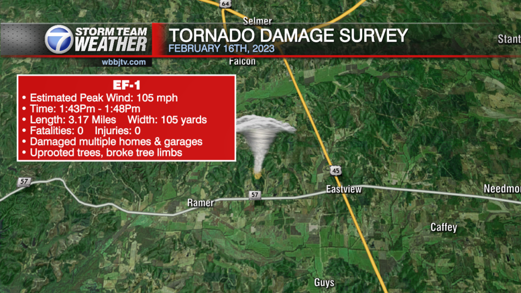
Thursday Morning Forecast Update for February 16th: WBBJ LIVE COVERAGE: www.wbbjtv.com/live A TORNADO WATCH will continue this morning until until 12 pm this afternoon. Please stay weather aware today and have a plan just in case you get put under…
Wednesday Night Forecast Update for February 15th: A TORNADO WATCH has been issued for sections of West Tennessee until 5 AM tonight. Strong rotating storms will move through out area tonight and…
Tuesday Night Forecast Update for February 14th: A warm front will lift northward into the Mid-South tomorrow, bringing increased moisture and temperatures to the region. A low pressure system will begin moving…

Monday Night Forecast Update for February 13th: It has been a amazing Monday so far and the warmer weather will continue through Thursday morning. Rain showers and windy conditions are expected for…
Saturday Morning Forecast Update for February 11th A low pressure area will skirt just to our south over the weekend bringing rain just off to our south. The main effect will be…

Thursday Night Forecast Update for February 9th After a rainy and windy night last night across West Tennessee, calmer weather is coming tonight. The winds will weaken and most of us will…

Wednesday Night Forecast Update for February 8th The severe weather threat looks quite low tonight across West Tennessee. The strongest storm of the night so far is in Hardeman county and moving…

Wednesday Morning Forecast Update for February 8th Most of us topped the 70° mark on Tuesday but the warmer weather will set the stage for multiple rounds of storms on today. Overall,…

Weather Update: Tuesday, February 7th Good Morning West Tennessee. We start out in the upper 40s and lower 50s over the area this morning along with mostly cloudy skies. We can't rule…

Monday Night Forecast Update for February 6th West Tennessee saw a beautiful finish to the weekend and a really nice start to the work week. Most of us will stay dry and…
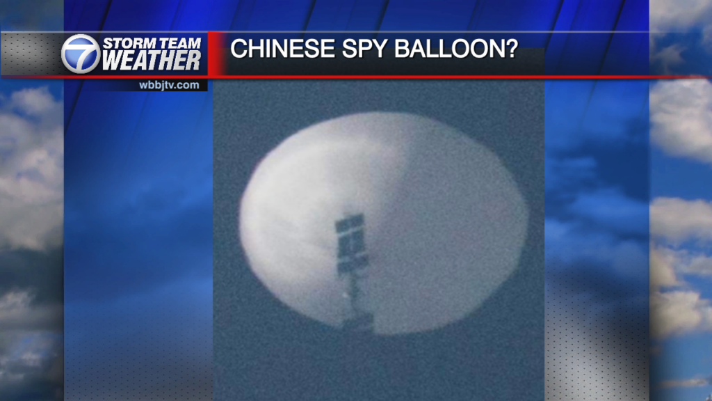
Saturday Night Forecast Update for February 4th Spy Balloon Or Weather Balloon? Many of us watched Today as the suspected "Chinese Spy Balloon" was shot down earlier this afternoon. China was…

Friday Night Forecast Update for February 3rd The sun came out today but the temperatures really didn't warm up much. It will be another chilly night across West Tennessee with most of…


