
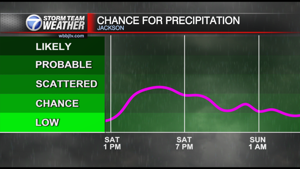
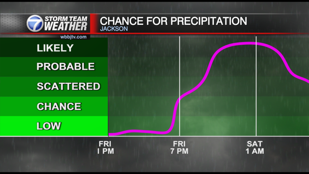
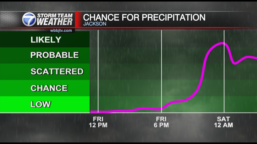
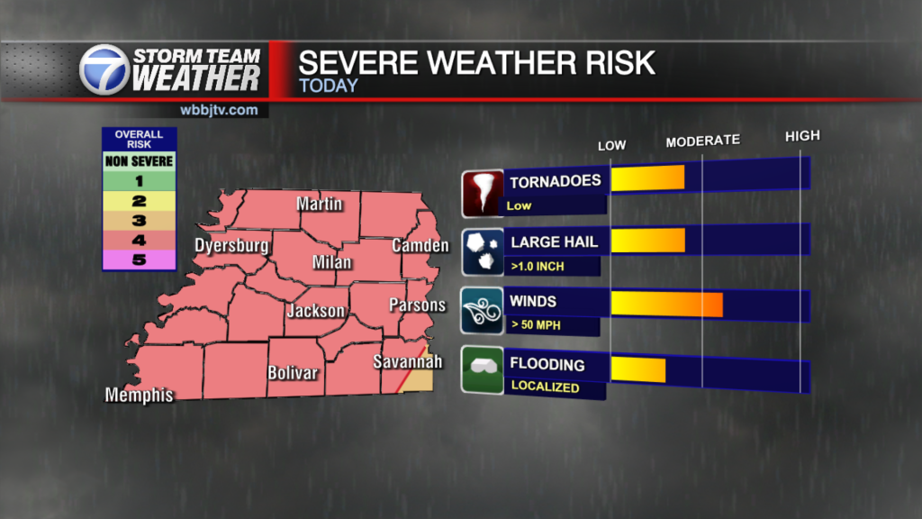
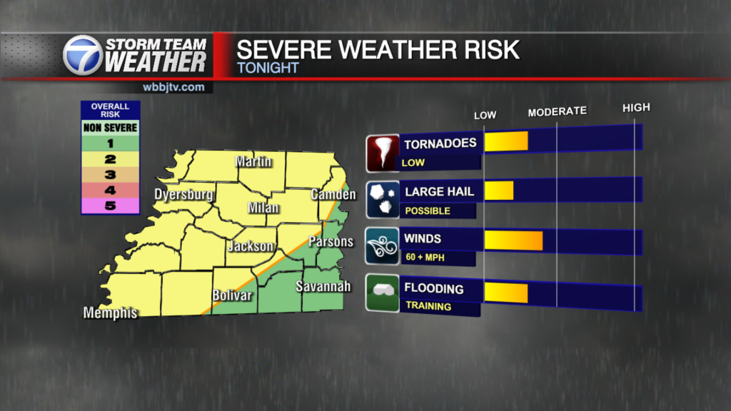
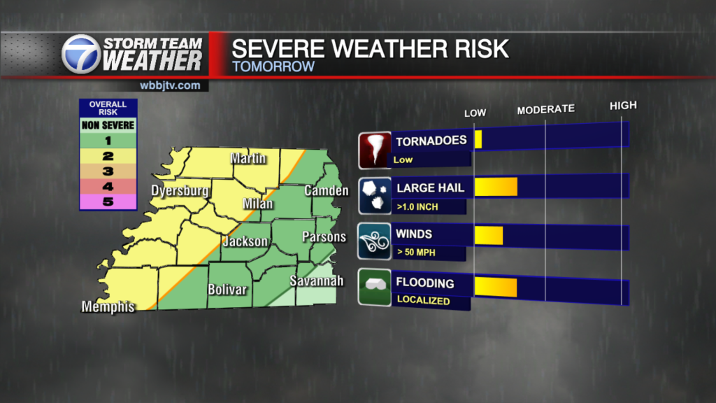
Showers & Storms Return This Afternoon And Evening
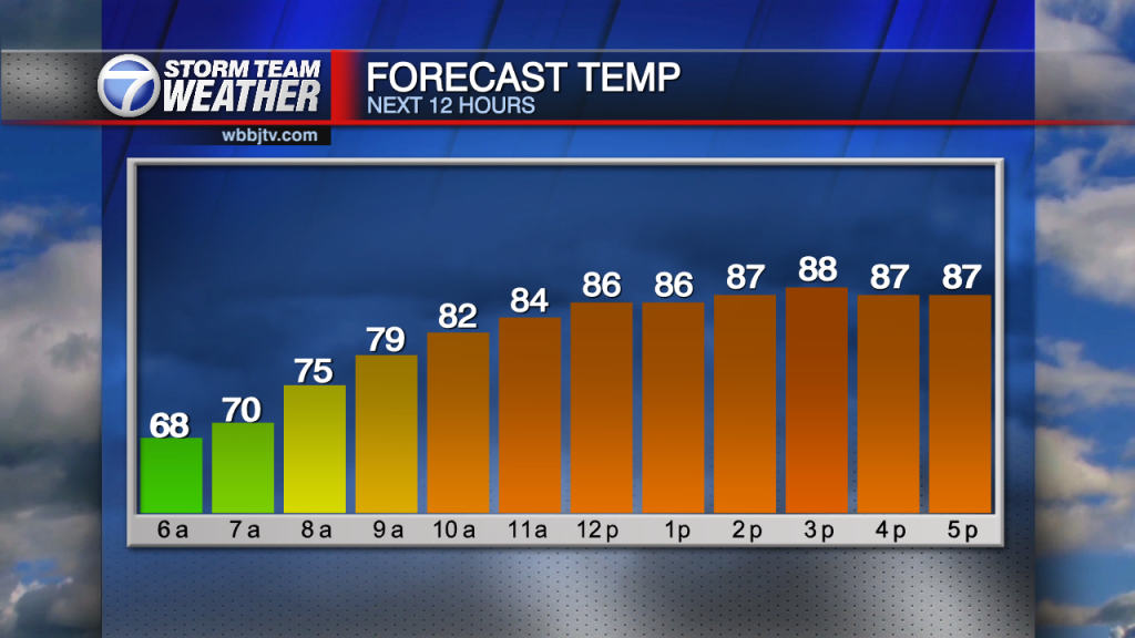
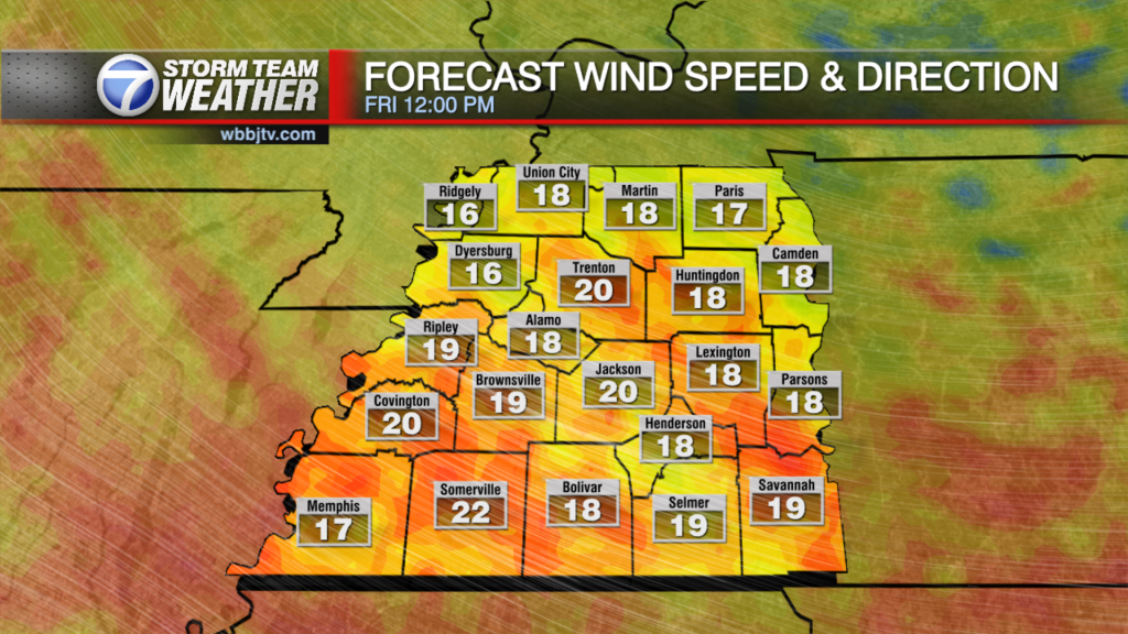
Friday Morning Forecast Update for May 13th: Good morning everyone on this Friday, May the 13th. We reached 93° yesterday in Jackson toppling a 60 year old record but a slight cool…
Friday Morning Forecast Update for May 13th: Good morning everyone on this Friday, May the 13th. We reached 93° yesterday in Jackson toppling a 60 year old record but a slight cool…
Thursday Night Forecast Update for May 12th: We reached 93° today in Jackson toppling a 60 year old record but a slight cool down is coming tomorrow with a chance for some…
Thursday Morning Forecast Update for May 12th: Starting off with a humid morning ahead with temperatures in the upper 60's and dewpoints in the middle to upper 60's making for a humid…

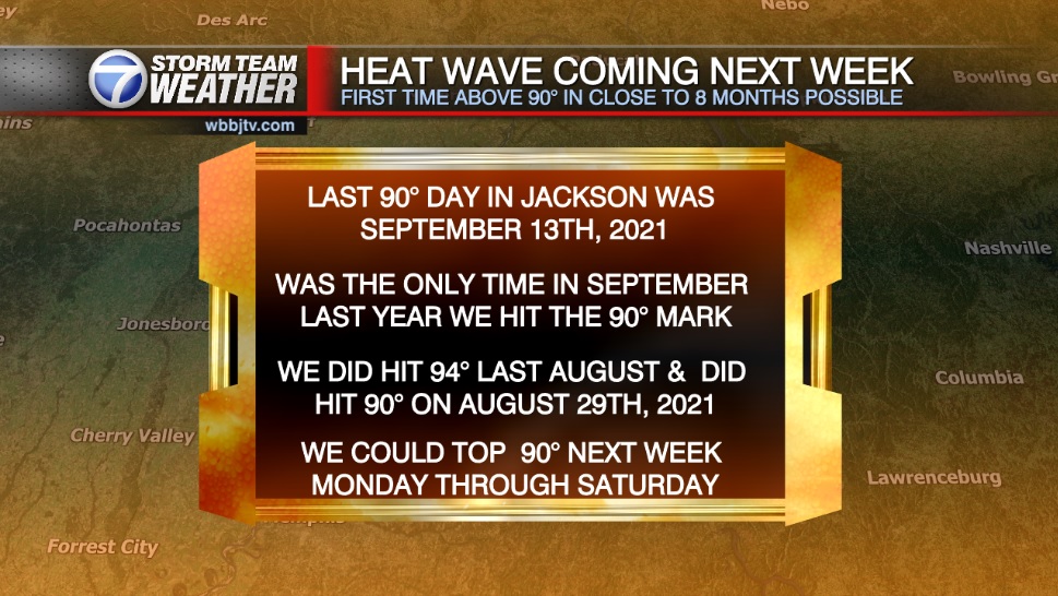
Wednesday Night Forecast Update for May 11th: We hit our first 90° of 2022 today in Jackson tying the record high from 60 years ago. We might break that record over the…

Tuesday Night Forecast Update for May 10th: Temperatures today have fallen just a couple degrees short of 90°, but many of us will top that mark on Wednesday. The record in Jackson is 90° and is 60 years old. Warm…

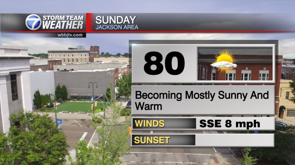
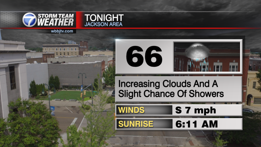
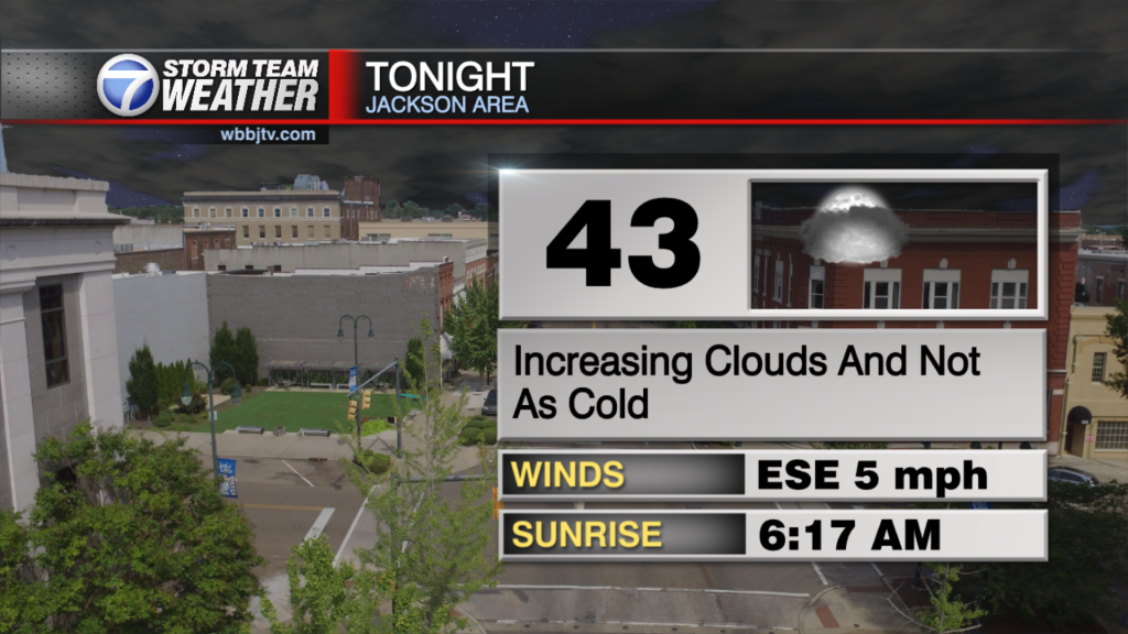
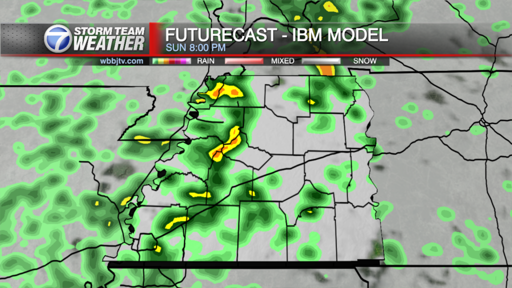
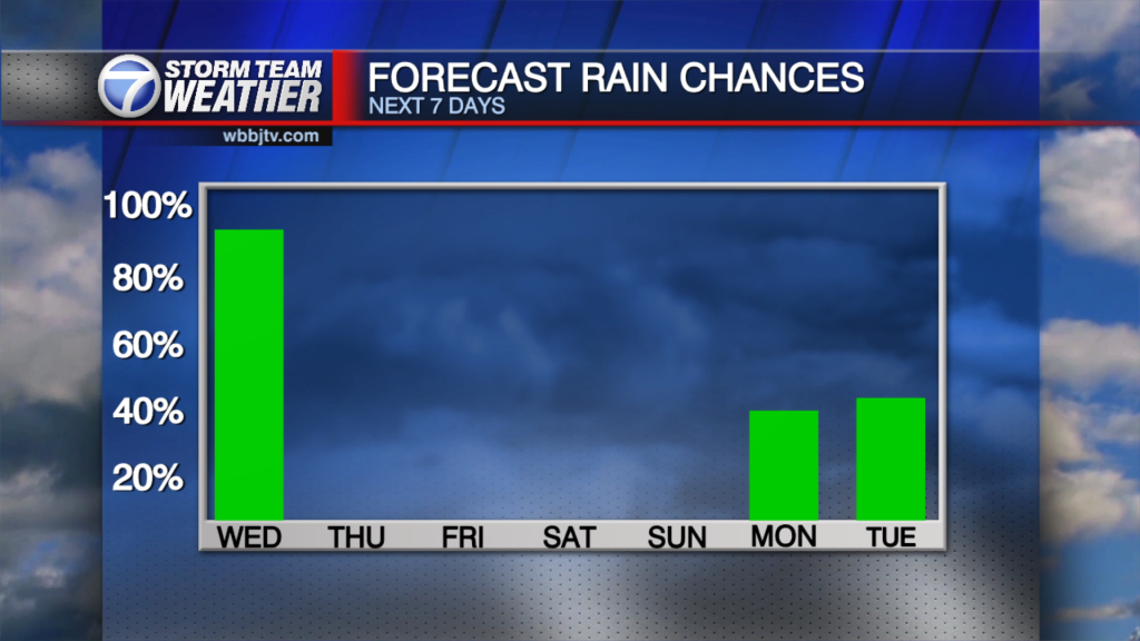
Monday Night Forecast Update for May 9th: A warm front pushed in from the south this morning and after some morning cloud cover and gusty winds it turned out to be a…

Saturday Forecast Update for May 7th: A cool and cloudy start this morning slight chance of a sprinkle with mostly cloudy skies through the late afternoon. Saturday Strawberry Fest Day Planner: The…
Friday Night Forecast Update for May 6th: The clouds might be sticking around a little longer into the weekend then we have been expecting. The low pressure system hasn't moved much over…
Thursday Night Forecast Update for May 5th: The severe weather and storm threat has wrapped us across West Tennessee but some showers will continue until around midnight. We will get a several hour break before another round of showers will…

Thursday Morning Forecast Update for May 5th: Yesterday was the 19th anniversary of the EF4 Jackson tornado in 2003 and that reminds us the we have to take a day like this…

Wednesday Night Forecast Update for May 4th: We will stay mostly dry and quiet tonight for the 19th anniversary of the EF4 Jackson tornado in 2003, but storm chances will be increasing…

Tuesday Night Forecast Update for May 3rd: Mostly dry, quiet and mild weather will be sticking around across West Tennessee until Thursday evening. Some strong and possible severe storms could move through…
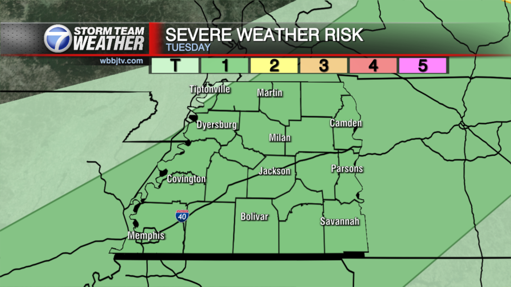
Tuesday Morning Forecast Update for May 3rd: A few showers possible this morning with showers and storms getting more active again in the late afternoon and evening. We'll catch a break in most…

Monday Night Forecast Update for May 2nd: Another round of thunderstorms is moving in from southern Missouri and northern Arkansas tonight and will impact some of our northern counties. Severe storms are not expected but loud thunderstorms with heavy rain…
Weather Update - Monday, May 2 - 5:38 AM We will move into an unsettled weather pattern this week with a number of shortwave disturbances moving through in the next couple…
Sunday Morning Forecast Update for May 1st: As of 1 am, the severe thunderstorm watch had been allowed to expire in Fayette county and no counties in west Tennessee are currently in…

Friday Night Forecast Update for April 29th: The beautiful weather will continue for Friday night and most of the day on Saturday. Showers and storm chances will return in the evening on…

Thursday Night Forecast Update for April 28th: Fantastic weather will stick around through Saturday evening. A few light showers could drift in tonight but don't count on seeing much. Some rain showers and storms could pass by Saturday night into…

Thursday Forecast Update for April 28th: Not as cold this morning but still a chilly start in the lower to middle 40's. Winds are calm so that helps to not feel…

Wednesday Evening Forecast Update for April 27th: We dropped down to 36° this morning out at the airport in Jackson setting a new low temperature record. Sunny skies and calm winds have…

Wednesday Update for April 27th: A chill in the air this morning as temperatures have dropped into the upper 30's under clear skies and calm winds. Expect some dew on the windows this…
Tuesday Night Update for April 26th: Chilly weather will move in tonight after the sun goes down across West Tennessee. Lows tonight will fall into the upper 30s for most of us.…

Tuesday Morning Update for April 26th: Starting out with some clouds this morning with a cooler start in the mid 40's. Clouds will move out later this morning and give way to…

Monday Night Update for April 25th: The clouds will clear out overnight and plenty of sunshine is expected for Tuesday and Wednesday. Temperatures will be a bit cooler behind the front and…
Weekend Update for April 24th: We've enjoyed a warmer and summer like weekend so far and the this evening will be no exception as the pleasant but more humid temperatures continue into…

Weekend Update for April 23rd: The awesome weather will stick around through the weekend with rain chances not expected to return until overnight Sunday into Monday morning. Severe weather or strong storms appears unlikely for us from that system. We…
Friday Night Update for April 22nd: The awesome weather will stick around through the weekend with rain chances not expected to return until overnight Sunday into Monday morning. Severe weather or strong storms appears unlikely for us from that system.…

Friday Update for April 22nd: A nice day on tap for your Friday with sunshine and highs in the lower 80's. Mostly sunny skies will hang around for Saturday as well before…
Thursday Night Update for April 21st: Our old friend humidity returned to West Tennessee today and will be sticking around through the weekend. Skies will slowly try to clear out tonight and…

Thursday April 21st: Rain and a few storms moved through overnight leaving some fairly impressive totals around west Tennessee. Rainfall amounts ranged from .4 inches to around 2 inches with the…

Wednesday Night Update for April 20th: A brief period of heavy rain showers and a few lightning strikes will move through the Hub City over the next hour before tapering on out. Some light rain chances and a few…
Weather Update - Tuesday, April 19 - 9:45 PM OUTLOOK: Clouds will increase overnight with mostly cloudy skies at the bus stop for morning. It want be as cold as it was…

Monday Evening Update for April 18th: Many areas in West Tennessee will be falling into the mid to upper 30s tonight and that could lead to some isolated areas of patchy frost. If you have some plants that might not…
Sunday Forecast Update for April 17th: Another low pressure disturbance will roll through the area late this evening bringing more organized rain to the west Tennessee. Showers and heavy downpours return through…
Saturday Forecast Update for April 16th: A stalled out cold front and a couple of disturbances will keep rain chances around through the weekend with mainly showers and a few weak…
Friday Forecast Update for April 15th: Enjoy one more dry day ahead as the weekend will feature showers at times. A weak cold front will drop through the area tonight bringing back…

Thursday Night Forecast Update for April 14th: Skies will remain clear tonight and the winds will be calm allowing temps to fall into the mid 40s. Mid 70s are coming for Friday…
Thursday Morning Forecast Update for April 14th: Dry weather moves in over the next couple of days as high pressure settles in bringing lower to calm winds for a change and…
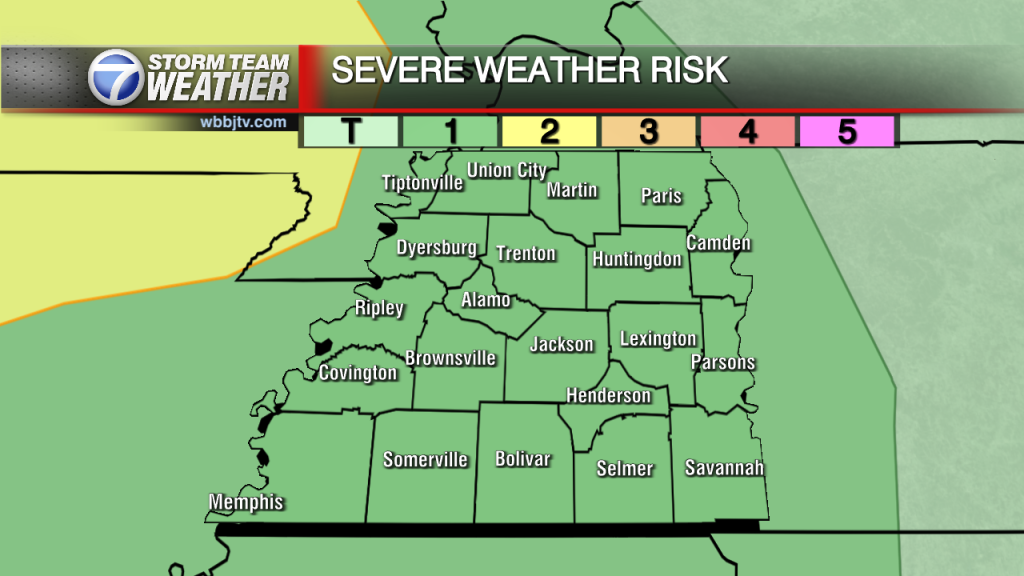
Wednesday Morning Forecast Update for April 13th: **UPDATE: The Moderate Severe Risk Has Been Extended Further East** TODAY: Showers and a few non severe storms are expected through the late…

Tuesday Night Forecast Update for April 12th: Some light rain showers have moved into West Tennessee tonight and some weak storm activity will move in between 10-11pm. Severe weather or strong storms…

Monday Night Forecast Update for April 11th: Supercell storms continue to rotate in Arkansas where a dangerous tornado touched down last hour near the Air Force Base north of Little Rock. These…
Weather Update - Monday, April 11 - 11:00 AM TODAY: A few showers began this morning that quickly intensified into a few storms. As we grow closer into the afternoon, the chance for storms increases, with a marginal and slight…
Sunday Evening Forecast Update for April 10th: Highs today topped out at a grand 81 degrees in Jackson while Alamo hit 82 degrees. Winds will continue to be brisk this evening as…

Saturday Forecast Update for April 9th: After cold temperatures of the morning in the mid 30's, warmer weather is on the way. Plenty of sunshine is expected today with highs topping out…
Friday Night Forecast Update for April 8th: Temperatures will be falling into the 30s after midnight tonight. As the skies clear out by sunrise, low 30s are expected for all of West…
Weather Update - Friday, April 8, 2022 - 8:00 AM TODAY: Friday morning begins with a few scattered showers across the area as moisture wraps around a low pressure to our north. Thankfully, only around a 15% chance of rain…

Thursday Night Forecast Update for April 7th: A few light showers will move through West Tennessee tonight and lows will again fall down into the upper 30s. Highs will struggle to hit…
Thursday Forecast Update for April 7th: A series of smaller disturbances will move through the area around a large upper level low to our north in the next few days. Rain will be…

Wednesday Night Forecast Update for April 6th: A few lingering light showers will continue this evening before moving out tonight. Mostly sunny, cool and breezy weather is on tap for Thursday. Cooler…
Weather Update - Wednesday, April 6, 2022 - 8:00 AM TODAY: Rain showers and storms start off early this morning and continue into the later afternoon hours with a marginal risk of severe weather still over our area. Heavy rain…


