
Isolated Showers And Warmer Temperatures
A powerful system continues to churn up showers and storms just south of the Tennessee border. Some isolated showers will continue to drift northward through Thursday and Friday but chances are slim…
A powerful system continues to churn up showers and storms just south of the Tennessee border. Some isolated showers will continue to drift northward through Thursday and Friday but chances are slim…
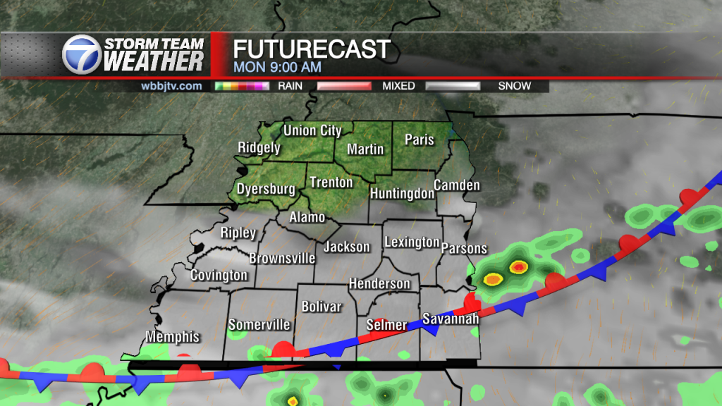
Tuesday Night Forecast Update for August 23rd: A powerful system continues to churn up showers and storms just south of the Tennessee border. Some isolated showers will continue to drift northward through…

Monday Night Forecast Update for August 22nd: A massive storm system bringing historic rainfall to Texas and Louisiana is tracking to the east and will move south of us. A few bands…
Weather Update - Sunday, August 21, 2022 - 5:15PM TODAY: Rain continued this morning in showers and strong storms. Rain total accumulations were greatest south of I-40 but may increase even more tonight. Showers continue before the passing front early…
Weather Update - August 20, 2022 - 6: 30PM TODAY: We started off this morning a little cool but it didn't take long for humidity to arrive ahead of some storms and showers. Many across the region saw some rain,…
Saturday Forecast Update for August 20th: Some scattered heavy downpours this morning on the edge of a warm front that is stretching over the area this morning. We've already seen radar estimates…

Friday Night Forecast Update for August 19th: You might need to keep an eye on the sky this weekend. Some isolated showers will pop up on Saturday and especially on Sunday as…

Thursday Night Forecast Update for August 18th: After a couple of cooler near record tying days, the sun came back out today and warmed us back into the mid 80s. The winds…

Wednesday Night Forecast Update for August 17th: The rain showers will moved out this evening and the clouds will follow tonight. Mostly clear skies and calm winds could allow some patchy fog to develop overnight, so be out on the…

Tuesday Night Forecast Update for August 16th: A weak front is moving through West Tennessee and will slowly linger across the Mid South through Wednesday Afternoon. The severe weather threat or any…

Monday Night Forecast Update for August 15th: We should stay dry tonight across West Tennessee but another round of showers and weak storms will move through West Tennessee on Tuesday and Wednesday.…

Weekend Forecast Update for August 13th and 14th: We started out in the low 60's this morning and a few of us had upper 50's! A nice little touch of Fall…
Friday Night Forecast Update for August 12th: It has been a marvelous Friday and the weekend will start out just as nice. The humidity will remain low on Saturday due to a…

Thursday Night Forecast Update for August 11th: A break from the rain will return to West Tennessee this tonight and stay away for a few days. Mild weather, mostly sunny and a…

Wednesday Night Forecast Update for August 10th: The storms have wrapped up tonight but some lingering rain showers are being stubborn. Coverage of the rain will diminish the next couple of hours…

Tuesday Night Forecast Update for August 9th: Most of the showers and storms tonight has fizzled on out or are drifting north of our viewing area. For the 3rd day in a…

Monday Night Forecast Update for August 8th: Minor flooding is occurring in some rivers, creek and streams across West Tennessee from the rain tonight. The National Weather Service in Memphis has issued…

Sunday Forecast Update for August 7th: Rain chances will continue to increase over the area each afternoon ahead of an approaching cold front around Wednesday. Showers and storms will increase in…
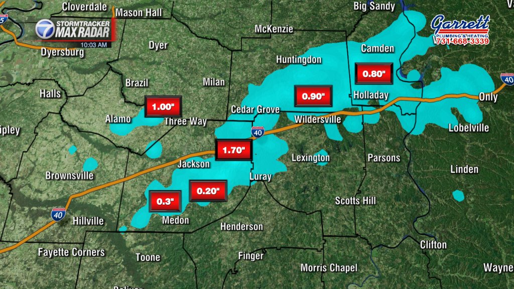
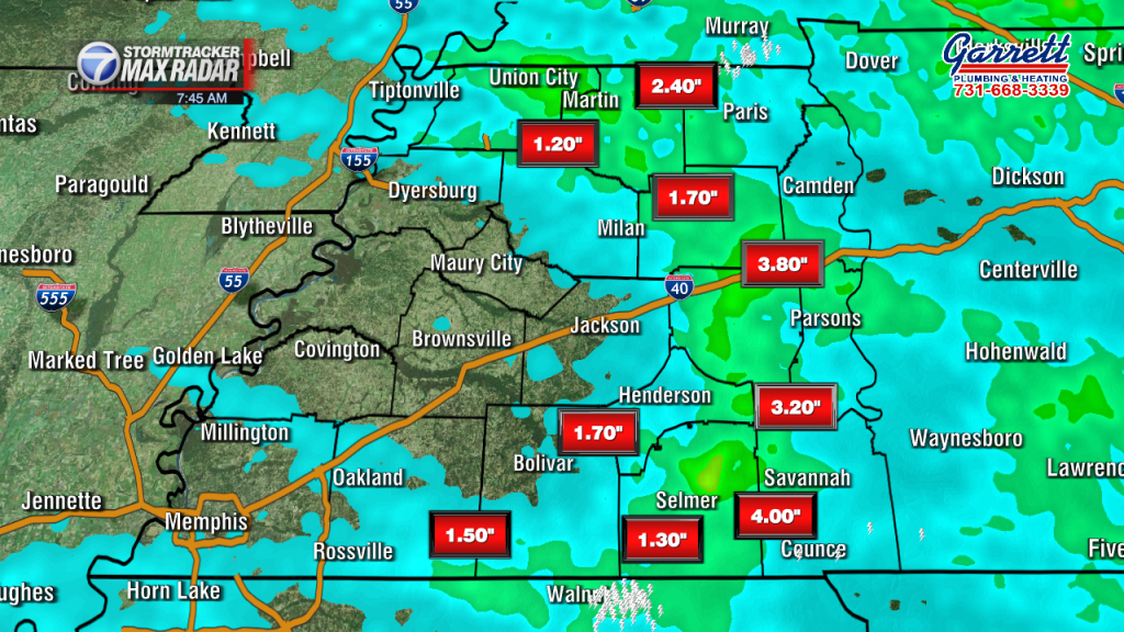
Saturday Forecast Update for August 6th: Here is a look at some of the rain totals from Friday morning across West Tennessee. Most locations north of I-40 saw 2" or more well…
Friday Evening Forecast Update for August 5th: Here is a look at some of the rain totals from Friday morning across West Tennessee. Most locations north of I-40 saw 2" or more…

Thursday Night Forecast Update for August 4th: Some isolated stationary showers and storms today left several inches on rain across sections of Hardeman county. Rain also came down in Chester and Henderson…

Wednesday Night Forecast Update for August 3rd: A storm system to our northwest has been slowly been moving to the southeast today and will bring a chance for showers and storms back…

Tuesday Evening Update for August 2nd: Some isolated showers and storms will try to move in from the northwest tonight and linger across northern sections of West Tennessee. Wednesday looks mostly sunny, warm and humid. Clouds and shower chances will…

Monday Night Update for August 1st: We could see a few lingering showers late tonight into early tomorrow morning, but most of us will not see much. A few pop up storms…
Weather Update: Saturday, July 30th A stalled out front over the midsouth will bring slow moving showers and storms over the area this weekend with totals between a quarter to up to…

Weather Update - Friday, July 29, 2022 - 4:00 PM TODAY: Rainfall made its way into west Tennessee this morning and has gradually cleared off the radar since. Highs reached into the lower 80's and will continue dropping back into…

Thursday Night Update for July 28th: Earlier today forecast guidance was suggesting rain showers would move into West Tennessee by 11PM and moving into Madison County around 2AM. The cold front appears…

Wednesday Night Update for July 27th: We are tracking a cluster of heavy rain showers and storms just west of the Mississippi River that will try to move through West Tennessee tonight.…

Tuesday Night Update for July 26th: Temperatures were in the mid to upper 90s and it felt 105-110° Tuesday afternoon, so the showers and storms that popped up were welcomed by most. …

Monday Night Update for July 25th: Highs will stay in the mid 90s for Monday and Tuesday, but will be dropping as the week goes on and highs are forecast in the…

Saturday Forecast Update for July 23rd: Highs will remain in the upper 90s for the weekend with a heat index around 105°. Sunny skies will stick around for the most part and the…

Thursday Night Forecast Update for July 21st: The cold front didn't bring much for rain, but did decrease the humidity across West Tennessee and dropped temperatures only a couple degrees. Highs reached…

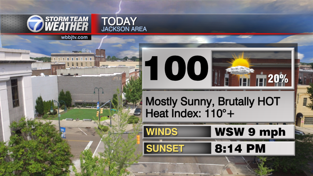
Wednesday Night Forecast Update for July 20th: If you factor in the humidity, today has been the hottest day of the summer so far. Its felt between 111-118° at 3pm across West…

Tuesday Night Forecast Update for July 19th: The only thing keeping us from melting today is the cloud cover lingering around West Tennessee. It still felt well over 100° west of Jackson…

Monday Evening Forecast Update for July 18th: Well most of West Tennessee picked up some beneficial rainfall Sunday night into Monday morning but unfortunately rain chances are not looking great this week. On top of the lack of rain, 100°…
Saturday Forecast Update for July 16th: The heat is going to be increasing today as southerly winds will increase the humidity across West Tennessee. Rain chances will increase as the day goes…
Friday Night Forecast Update for July 15th: The heat is going to be increasing into the day on Saturday as southerly winds will increase the humidity across West Tennessee. Rain chances will…

Thursday Night Forecast Update for July 14th: Our 92° or hotter heat streak has now been extended to 16 straight days for Jackson. We have not seen a day below normal during…

Wednesday Evening Forecast Update for July 13th: Many areas south of I-40 picked up some well needed rain last night and this morning. We didn't see any at all in Madison, Gibson, Crockett and Carroll counties unfortunately. The front did…

Tuesday Night Forecast Update for July 12th: Chances for showers and storms are diminishing tonight as the system has produced storm activity all over Middle Tennessee and Arkansas but so far has…

Monday Night Forecast Update for July 11th: Less humid weather has moved in behind this weekend's cold front and the extreme humidity should stay away from West Tennessee this week. Highs will…
Saturday Forecast Update for July 9th: Storms came through overnight prompting a few power outages over the Gibson and Obion area early this morning. Up to 4 inches of rain was estimated…
Friday Night Forecast Update for July 7th: There is a 50/50 chance you will see some rain showers tonight and tomorrow morning if you live in West Tennessee. I wish I could…
Friday Forecast Update for July 8th: We are in the middle of the hottest heat outbreak in West Tennessee since 2012 and we are not expecting to cool down until Saturday. A…

Thursday Night Forecast Update for July 7th: We are in the middle of the hottest heat outbreak in West Tennessee since 2012 and we are not expecting to cool down until Friday…

Wednesday Evening Forecast Update for July 6th: We officially topped out at 99° here in Jackson Today as the heat index hovered around 110°. The heat index Wednesday was between 106-115° and…

Tuesday Night Forecast Update for July 5th: For the second time in 2022 the National Weather Service in Memphis has issued an Excessive Heat Warning for sections of West Tennessee. The heat…
Monday Night Forecast Update for July 4th: Although a shower or two cannot be ruled out, most of West Tennessee will stay dry tonight for all your 4th of July plans. Skies…
Weather Update - Sunday, July 3, 2022 - 3:30 PM TODAY: Another hot and humid day remained in West Tennessee today with highs in the mid 90's. A few scattered showers and isolated storms continue but aren't dropping much in…
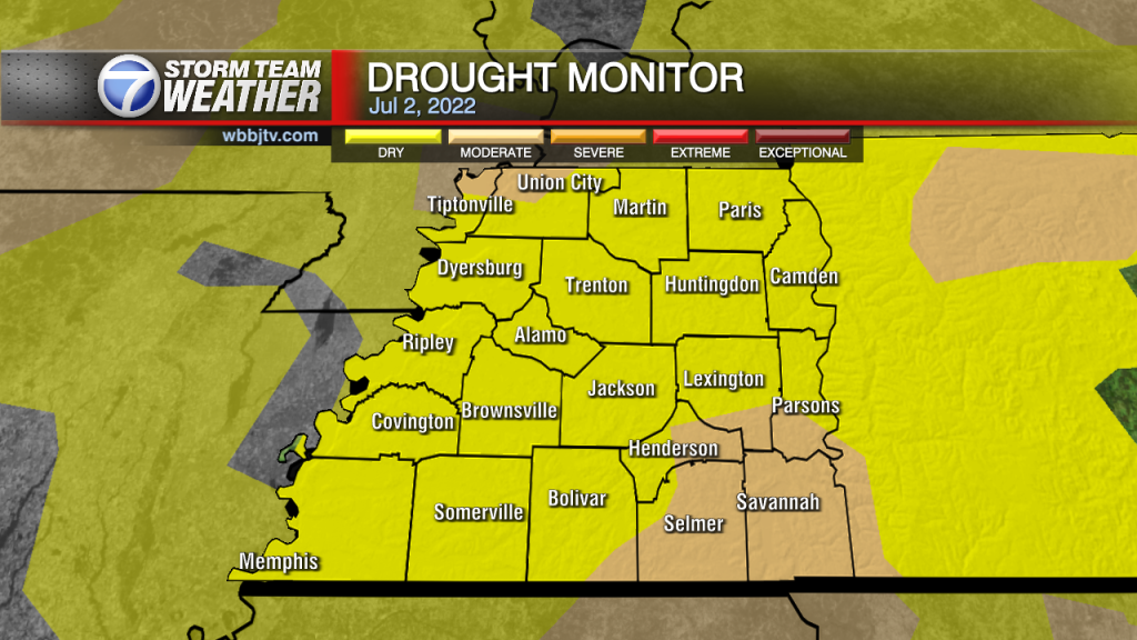
Weather Update - Saturday, July 2, 2022 - 4:00 PM TODAY: Another hot and humid day remained in West Tennessee today with highs in the mid 90's. A few scattered showers and isolated storms continue but aren't dropping much in…


