
Pop Up Storms Into The Holiday Weekend
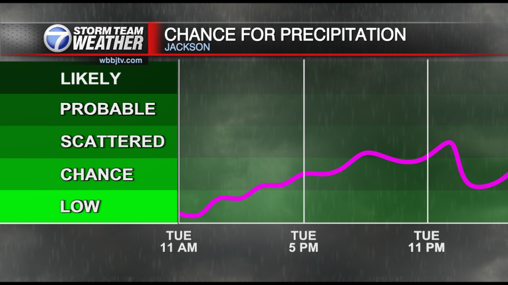
Saturday Forecast Update for July 2nd: We will see another round of showers on Saturday and Sunday. If you have outdoor plans this weekend, just be aware a weak storm or shower…
Saturday Forecast Update for July 2nd: We will see another round of showers on Saturday and Sunday. If you have outdoor plans this weekend, just be aware a weak storm or shower…

Friday Night Forecast Update for July 1st: We will see another round of showers on Saturday and Sunday. If you have outdoor plans this weekend, just be aware a weak storm or…

Thursday Night Forecast Update for June 30th: The heat and humidity returned to West Tennessee on Thursday, but also did some showers and weak storms. Expect another round of isolated showers on…

Wednesday Night Forecast Update for June 29th: We will stay day tonight, but shower chances will return to the region on Thursday. They will be scattered and of the pop up variety,…

Tuesday Night Forecast Update for June 28th: A cool and pleasant air mass continues to linger over West Tennessee and should stick around for most of the day on Wednesday. Some shower…

Monday Night Forecast Update for June 27th: Most of West Tennessee picked up some precipitation on Sunday, but everyone is dealing with the cooler weather which will continue through Tuesday. Temperatures will…
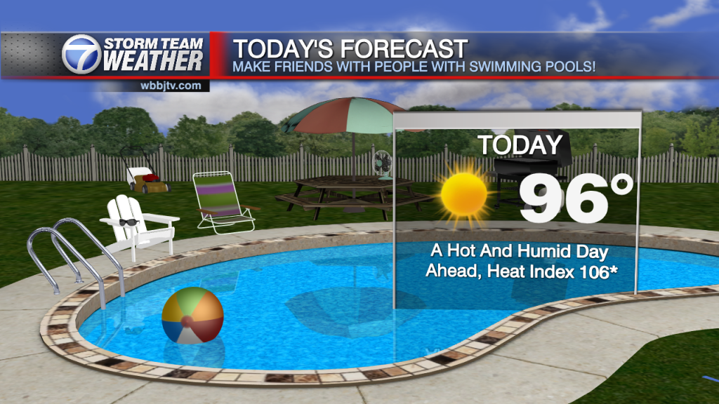
Saturday Forecast Update for June 25th: Hot weather again today as the heat index likely to hit as high as 106 degrees. Lack of much wind and higher dewpoints and temperatures in…

Friday Night Forecast Update for June 24th: The weather will remain nice and mild for Friday night, but will heat back up into the day on Saturday. Clouds and shower chances will…

Thursday Night Forecast Update for June 23rd: Behind the weak front, temperatures are about 5° cooler today then yesterday, but the humidity is lower as well. That will continue for Friday across…

Wednesday Night Forecast Update for June 22nd: Our rain chances have wrapped up tonight but will be coming back this weekend to West Tennessee. A weak front will drop both the temperature…

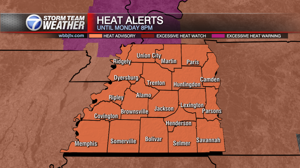
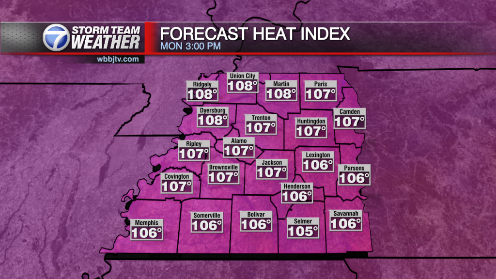
Tuesday Night Forecast Update for June 21st: The hottest day during the work week looks like it is going to be here on Wednesday. A heat advisory is out from 11AM until…

Monday Night Forecast Update for June 20th: After a very pleasant and not humid weekend and start to the work week across West Tennessee, another heat wave is on the way. Highs…
Sunday Night Forecast Update for June 19th: Saturday's official high as of 5 pm was 89 degrees and provided we don't go another degree higher that would put us on track for…

Friday Night Forecast Update for June 17th: The clouds are clearing out tonight and a drier and cooler air mass will be moving in for the weekend. Take advantage of the weekend…

Thursday Night Forecast Update for June 16th: A heat advisory continues until 8 PM Friday evening and a front will cool things down back closer to normal for the upcoming holiday weekend.…

Wednesday Night Forecast Update for June 15th: The heat will continue to impact West Tennessee until Friday afternoon. A cold front will pass on Friday cooling things down some for the upcoming holiday weekend. The heat index will stay over…

Tuesday Night Forecast Update for June 14th: If you head outside tonight and look to the south, you can see the full strawberry supermoon across the lower section of the sky. With…

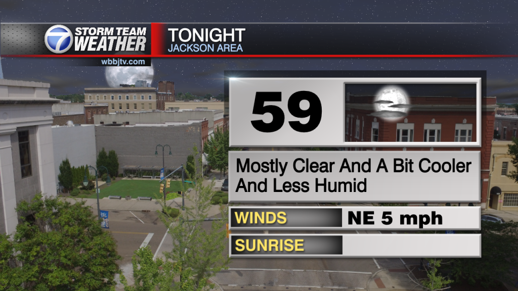
Monday Night Forecast Update for June 13th: With dew points still sitting in the upper 70s across most of West Tennessee, temperatures still feel in the 90s at 9:30pm Monday night. The…
Weather Update - Saturday, June 11, 2022 - 7:00 AM TODAY: More heat and humidity will continued today with highs lower 90's but feels like temperatures in the hundreds. A heat advisory was in effect from 11AM until 8PM and…
Weather Update - Saturday, June 11, 2022 - 7:00 AM TODAY: We're continuing on our warming trend this morning but overall, today looks pleasant compared to next week. A dense fog advisory is in effect this morning until 9AM, with…

Friday Night Forecast Update for June 10th: The showers and storms missed most of us here in West Tennessee on Friday and might not return for several days. The clouds will break…

Thursday Night Forecast Update for June 9th: Skies will remain mostly clear tonight, the humidity will stay low and the winds will be calm. Clouds will move back in tomorrow and some…

Wednesday Night Forecast Update for June 8th: A weak front will move through West Tennessee tonight but will not bring much for rain with it. The winds though will shift from the…

Tuesday Night Forecast Update for June 7th: The showers and storms have cleared out tonight but it will remain warm and humid. That will help set the stage for more showers and…

Monday Night Forecast Update for June 6th: A line of strong and potential severe storms extends from Camden to Rossville in West TN tonight. The storms are moving through Jackson now. 40 MPH Winds, Heavy rain, explosive lightning and pea…
TODAY: We started off the morning in the lower to middle 50's. In the 6 am hour we had 54 degrees in the Lexington and Parsons area while Jackson came in at 55.…
Weather Update - June 3, 2022 - 5:00 PM TODAY: We had perfect conditions today across the region with highs in the lower 80's, lower dew points, a nice breeze, and plenty of sunshine. A few clouds will remain into…

Thursday Night Forecast Update for June 2nd: The rain has cleared out and the clouds are going to follow overnight. Plenty of sunshine will be moving in for Friday and sticking around…

Thursday Morning Forecast Update for June 2nd: Good Thursday Everyone...A few showers over parts of Benton, Decatur, And Hardin this morning as the rest of the area dries out some. Some rain…
Thursday Morning Forecast Update for June 2nd: Good Thursday Everyone...A few showers over parts of Benton, Decatur, And Hardin this morning as the rest of the area dries out some. Some rain…

Tuesday Night Forecast Update for May 31st: A storm system is producing thunderstorms across the Southern Plains tonight and will slowly march to the east on Wednesday. As the frontal boundary approaches…

Monday Night Forecast Update for May 30th: With the new moon and mostly clear skies, a meteor shower could be visible in the West Tennessee skies tonight if you look north towards…
Weather Update - Sunday, May 29, 2022 - 7:00 PM TODAY: We started off with plenty of sunshine today with a strong ridge of high pressure over the area. Highs remained in the mid 80's with winds in the lower teens.…

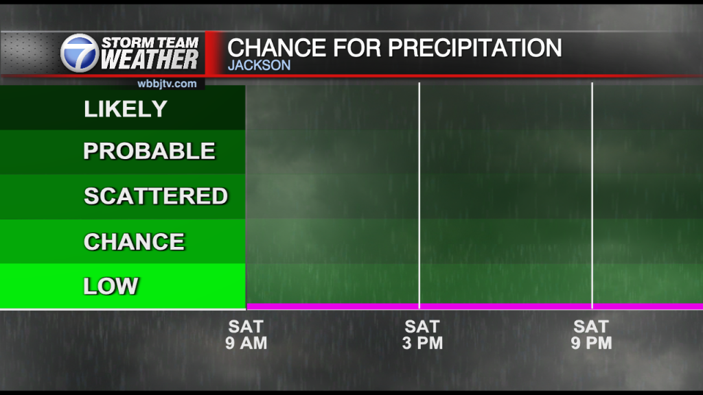
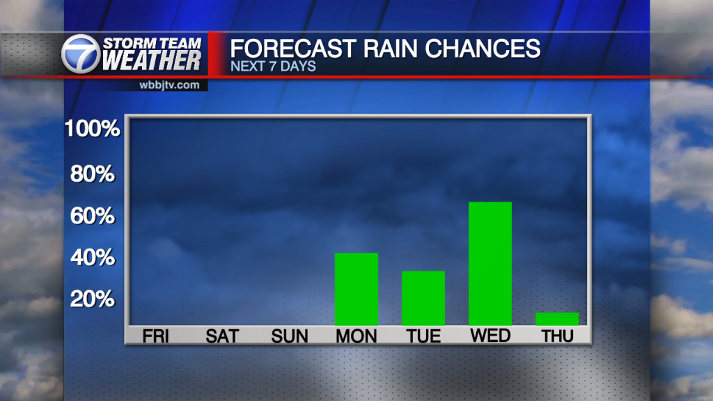
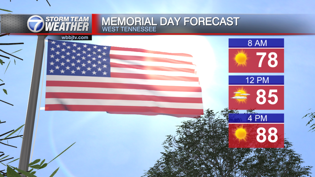
A strong ridge of high pressure will continue over the area through the weekend and finally allowing some sunshine to return just in time for our Memorial Day weekend! We'll be…
Friday Night Forecast Update for May 27th: Calm winds and sunny skies with highs near 80° can be expected on Saturday for the start of our Memorial Day Weekend here in West…

Thursday Night Forecast Update for May 26th: The low pressure that brought all the clouds and rain to West Tennessee this week is still sitting to our northwest tonight. A few light…

Wednesday Evening Forecast Update for May 25th: Another round of rain showers and weak storms are coming up from the south this afternoon and will move through Jackson between 3:30-4:30pm. Brief heavy rain and some lightning will be possible with…
A low pressure system will move through West Tennessee this week bringing several rounds of rain showers and storm chances with it. Severe weather is not going to be widespread but storms…

Monday Evening Forecast Update for May 23rd: Behind Sunday's cold front, much cooler weather has returned to West Tennessee. The northerly winds will change to the east on Tuesday and back to…
Weather Update- Monday, May 23rd, 2022. A low pressure system hangs off to our southeast today bringing cloudy skies through at least mid to late afternoon before moving further east and…

Saturday Forecast Update for May 21st Most of our Saturday will be under dry weather but the evening will bring storms of which could be severe at times. You'll want to be…
Weather Update - Friday, May 20, 2022 - 11:00 AM TODAY: We're expecting plenty of sunshine today with a few clouds moving in. This will bring partly to mostly sunny skies for most of the region. Highs are expected in…

Thursday Night Forecast Update for May 19th: Highs will remain in the upper 80s for both Friday and Saturday for most of West Tennessee. Clouds will increase Saturday afternoon. Showers and storms…

Thursday Forecast Update for May 19th: Starting off with some high thin clouds against the blue sky this morning. Temperatures in the upper 60's and low 70's. A stalled out cold…

Wednesday Night Forecast Update for May 18th: A stalled out cold front will sit just north of the Tennessee/Kentucky border on Thursday and could bring some showers or a few storms to our northern counties. Most of us will stay…

Tuesday Night Forecast Update for May 17th: A weak boundary from the west will increase the clouds some this evening but the showers should dissipate before they reach us. A front will…

Monday Night Forecast Update for May 16th: Behind Sunday night's cold front, a cooler and less humid air mass has returned to West Tennessee. The winds will shift back from the north…

Weather Update - Sunday, May 15 - 7:00 PM TODAY: A very warm day was ahead of us with a high of 87 here in Jackson. We did see a little sunshine before clouds moved in ahead of the cold…
Saturday Evening Forecast Update for May 14th: A few pop up showers and storms mainly the later part of the day with most areas staying dry until Sunday evening. A few convective…

Friday Evening Forecast Update for May 13th: A line of thunderstorms producing very heavy rain, thunder and lightning will continue to drift east across West Tennessee for the next few hours. The storms are beginning to move into Crockett, Madison,…


