
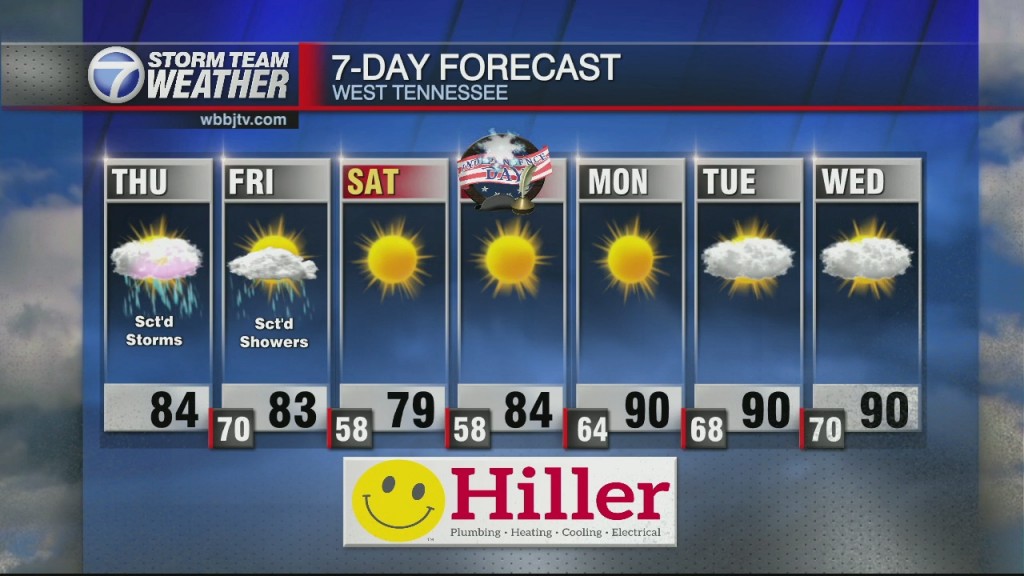
Cool & Mild Tonight, Heat & Humidity Returning this Weekend!
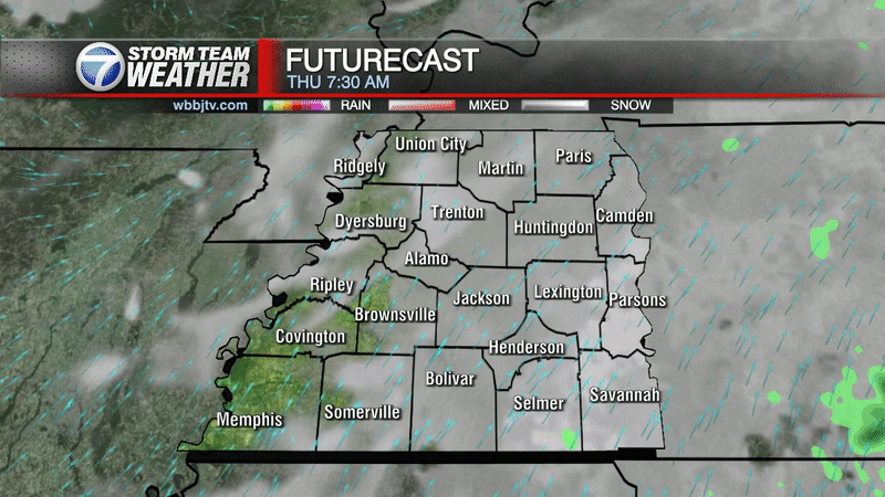
Wednesday Night Forecast Update for August 4th: After a 3rd consecutive day in a row of warm, sunny and not humid weather for West Tennessee, we have another one coming in for…
Wednesday Night Forecast Update for August 4th: After a 3rd consecutive day in a row of warm, sunny and not humid weather for West Tennessee, we have another one coming in for…

Tuesday Night Forecast for August 3rd: Behind Sunday's cold front, northerly winds have brought in some drier and cooler weather that is expected to stick around for the rest of the work…
Forecast For Monday Evening Into Tuesday, Issued Sunday August 2nd, 7:40 PM: *A quick recap on the Saturday night and Sunday morning storms: Storms caused power outages overnight as what looked…

Forecast For Sunday Evening Into Monday, Issued Sunday August 1st, 6:41 PM: *A quick recap on the Saturday night and Sunday morning storms: Storms caused power outages overnight as what looked…
Sunday Forecast for August 1st: Storms caused power outages overnight as what looked to be up to 70 mph winds on radar slammed through parts of Madison, Chester, Henderson, Decatur, and Benton counties. Power was reported out in several locations…

Friday Night Forecast for July 30th: After a very humid and hot day again across West Tennessee, some pop up storms and rain showers helped cool things off some for Friday evening.…

Friday Forecast for July 30th: **A heat advisory goes in effect again today until 7 pm and again tomorrow from 11 am to 7 pm. Two more hot days before…
Thursday Night Forecast for July 28th: A heat advisory remains in effect through Friday with 105°+ heat indices expected at times until Saturday evening. A cold front will approach on Saturday bringing…

Wednesday Night Forecast for July 28th: It will remain sunny, hot and dry this evening and the heat will continue for Thursday. Some of us could reach the upper 90s on Thursday.…

Tuesday Night Forecast for July 27th: Another Heat Advisory has been issued for Madison County for Tuesday Afternoon. Sunny and hot weather is expected for the rest of the work week with highs reaching the mid to upper 90s with…

Weather Update: Tuesday, July 27 -- Good Morning West Tennessee. We have another warm and humid start to the morning with temperatures settling around the lower 70s. It is leading to a bit of dense fog especially towards the Tennessee,…

Monday Night Forecast for July 26th: After the hottest day of the year so far in West Tennessee, if you factored in the humidity; some pop up showers and storms developed and…

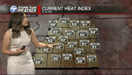
Weather Update - 4:00 PM - Sunday, July 25 TODAY: We started off the weekend mainly dry and very warm. Across the region, heat index values were bridging into those triple digits. We also had a heat advisory in affect…
Weather Update - 4:45 PM - Saturday, July 24 TODAY: We started off the weekend mainly dry and very warm. Across the region, heat index values were bridging into those triple digits. Winds remained fairly low and high dew points…
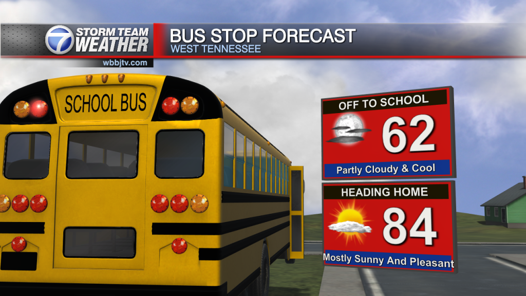
Saturday Forecast for July 24th: A warmer day ahead as heat index reading will be well over 100 in the afternoon and we could end up with a heat advisory…

Friday Night Forecast for July 23rd: The weekend is expected to be mostly sunny and hot with a "feels like" temperature reaching into the 100s due to the high humidity. Some rain…

Thursday Night Forecast for July 22nd: A warm front will move up from the south to finish the work week bringing widespread light shower activity on Friday to West Tennessee. The heat…

Wednesday Night Forecast for July 21st: Smoke and haze was quite apparent across West Tennessee today from large wild fires burning across The West and Southern Canada. The smoke will continue to stick around until the winds shift back to…

Tuesday Night Forecast for July 20th: The storm system bringing all the showers on Sunday & Monday to West Tennessee will finally be pushed to the southeast by a high pressure system…

Monday Night Forecast for July 19th: After picking up a widespread 1-3" of rainfall across West Tennessee over the last 36 hours, more rain will continue tonight along & south of I-40.…
Weather Update - 3:45 PM - Sunday, July 18 TODAY: A few scattered showers and storms passed through the region this morning. The majority of the storms remained north of I-40 but most of the region has seen a little…

Weather Update - 3:45 PM - Saturday, July 17 TODAY: A few scattered showers and storms passed through the region this morning. We remained cloudy and humid throughout the region with sunshine beginning to peek out this afternoon. Overnight, we…
Saturday Forecast for July 17th: A mid level trough of low pressure and a slow moving cold front will keep a boundary over the area for scattered storms and although the…

Friday Evening Forecast for July 16th: Although the severe weather threat is low this evening, storms producing gusty winds, heavy rain and lightning will impact most of West Tennessee. A stalled out front will keep storm chances around all weekend…

Thursday Night Forecast for July 15th: After a hot, humid and mostly dry day across West Tennessee, changes are in the forecast starting on Friday. The timing of the storms on Friday…

Wednesday Night Forecast for July 14th: After a mostly dry, hot and humid day across West Tennessee, similar weather is expected tomorrow with a few more pop up storms then we saw…

Tuesday Night Forecast for July 13th: After back to back days filled with pop up showers and storms impacting the majority of West Tennessee, a couple of mostly dry days will be…

Monday Night Forecast for July 12th: Monday brought another round of heavy rain and storms to West Tennessee. We didn't have any severe weather, but some clouds that resembled a tornado developed…
Weather Update - 4:45 PM - Sunday, July 11 TODAY: Storms and showers moved across parts of the region this morning. Highs into the mid 80's were seen as we remain slightly below average. A few more thunderstorms could be…

Weather Update - 6:30 AM - Sunday, July 11th The current severe threat will be slightly lower than Saturday but the threat of flash flooding will continue to grow with already saturated ground and more storms forecast for today and…
Weather Update - 4:45 PM - Saturday, July 10 TODAY: Storms and showers moved across parts of the region this morning. Highs into the mid 80's were seen and conditions remained humid. We do remain in a slight risk of…

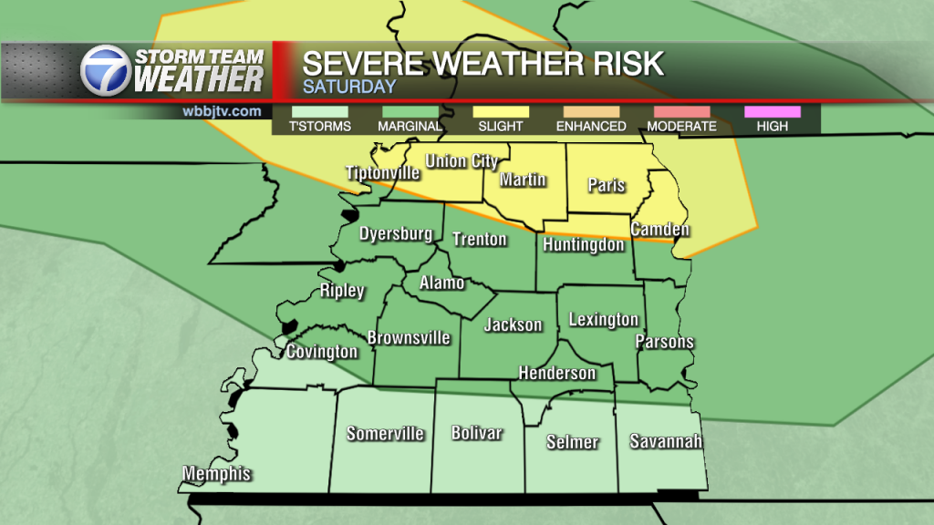
Saturday Forecast for July 10th: Our most significant storm threat in several weeks is coming for the weekend and storms look likely between Saturday night and Monday morning. If you…

Friday Night Forecast for July 9th: After a stormy Thursday night, storms developed again along a warm front this afternoon in West Tennessee. It is a humid and warm night in West…

Thursday Evening Forecast for July 8th: The heat index is around 100° this afternoon but some pop up showers will try to cool us down and similar weather is expected on Friday. Our most significant storm threat in several weeks…
Weather Update: Thursday, July 8 -- Good Morning West Tennessee. We have another somewhat gloomy morning with a stratus deck of elevated fog to start. Like yesterday, it will burn off giving way to mainly sunny skies this afternoon. The…

Wednesday Night Forecast for July 7th: Areas near the Tennessee River dodged some pop up rain showers on Wednesday, but most of the region didn't see much. If you didn't get any…

Tuesday Night Forecast for July 6th: After several mild, not humid and rain free days across West Tennessee, changes are expected to move in on Wednesday. Severe weather is NOT likely, but…

Monday Night Forecast for July 5th: After a fantastic weekend and mild start to the work week, changes are coming for the middle of week and likely sticking around into next weekend.…

Weather Update - 11:00 AM - Monday, July 5th TROPICAL STORM ELSA: While hurricane season started on June 1st, the first hurricane of the season formed Friday morning- Hurricane…

Weather Update - 5:00 PM - Sunday, July 4 HURRICANE SEASON UPDATE: While hurricane season started on June 1st, the first hurricane of the season formed Friday morning- Hurricane Elsa. It is currently sitting off in that Atlantic and has…
Weather Update - 4:00 PM - Saturday, July 3 HURRICANE SEASON UPDATE: While hurricane season started on June 1st, the first hurricane of the season formed Friday morning- Hurricane Elsa . While right now, it is well into the Atlantic…

Saturday Forecast for July 3rd: After a warm and humid week, a cold front has moved through bringing less humid air along with light northeast breezes. Sunshine will be abundant for…

Weather Update - 4:00 PM - Friday, July 2 HURRICANE SEASON UPDATE: While hurricane season started on June 1st, the first hurricane of the season formed Friday morning- Hurricane Elsa . While right now, it is well into the Atlantic…

Thursday Night Forecast for July 1st: Rain will wrap up in the Hub City by 10 PM tonight and move out across all of West Tennessee before the sun comes up on…
Weather Update: Thursday, July 1 -- Most of the area is starting off just humid with mostly cloudy skies. But there have been a few showers. I do expect activity to increase…

Wednesday Night Forecast for June 30th: After picking up some well needed rain in West Tennessee on Tuesday & Wednesday, more rain is likely on Thursday as the front sitting to our…
Weather Update: Wednesday, June 30 -- Good Morning West Tennessee. we have a warm and humid start to the morning. There was plenty of fog, but it will or has burned off fairly. Otherwise, I expect skies to be mainly…

Tuesday Night Forecast for June 29th: If you missed out on the rain Tuesday, or just didn't get enough, you have more chances this week. Some pop up showers will be possible…

Tuesday Forecast for June 29th: Increasing rounds of showers and thunderstorms over the next couple of days followed by a cooler and less humid air-mass arrival just in time for the…

Monday Night Forecast for June 28th: After only a few showers on Monday, chances will increase on Tuesday, with rain looking like for most of us at times on Wednesday & Thursday…


